
Taroko National Park facts for kids
Quick facts for kids Taroko National Park |
|
|---|---|
|
IUCN Category II (National Park)
|
|

The Taroko Gorge
|
|

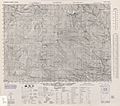
Map of Taroko national park
|
|
| Location | Taiwan |
| Nearest city | Hualien |
| Area | 920 km2 (360 sq mi) |
| Established | 28 November 1986 |
Taroko National Park (Chinese: 太魯閣國家公園; pinyin: Tàilǔgé gúojiā gōngyuán; Pe̍h-ōe-jī: Taroko kok-ka kong-hn̂g) is a special place in Hualien County, Taiwan. It is a national park, which means it is protected by the government. Taroko National Park was the fourth national park ever created in Taiwan. It is also the third-biggest national park in the country.
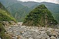
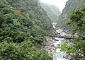
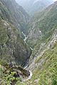
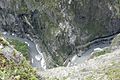
This park is famous for its amazing natural beauty. It has tall mountains and steep cliffs. The most well-known part of the park is the incredible Taroko Gorge.
Contents
History of Taroko National Park
The name "Taroko" comes from the Truku language. It means "magnificent" or "beautiful." This name perfectly describes the park's stunning scenery.
How the Taroko Gorge Was Formed
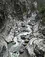
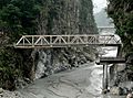
The amazing Taroko Gorge was created by the Liwu River. Over a very long time, the river slowly cut its way through the hard rock. This process carved out the deep, narrow gorge we see today.
People of the Park
For more than 300 years, the Atayal and Sedek tribes have lived in this area. Researchers have found traces of over 70 villages that belonged to these tribes. There was an old path called the Northern Road that led to Taroko. Later, the Qing Dynasty improved this path. The Japanese also built a system of roads along the coast.
Gold Mining in the Past
People started looking for gold in this area a long time ago, in the 17th century. Gold mining happened when the Dutch ruled Taiwan. It also continued during the Qing Dynasty and when the Japanese ruled. The Japanese began mining gold in the Liwu River in 1918. There were plans to mine even more gold, but World War II started. Later, the Kuomintang government in Taiwan stopped all gold mining.
Creating the National Park
The park was first made a national park in 1937. At that time, Taiwan was ruled by the Japanese. They called it Tsugitaka-Taroko National Park. When the Chinese government returned to Taiwan in 1945, they closed the park.
In the 1950s, Chiang Kai-shek wanted a road that would cross Taiwan from west to east. This important road, called the Central Cross-Island Highway, opened in 1960. It goes right through the Taroko Gorge.
The park was officially created again in 1986. This was an important step. It showed that the Taiwanese government understood the need to protect the environment.
Geography of Taroko
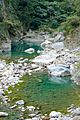
Taroko National Park is full of natural wonders. It has many rivers, beautiful waterfalls, and deep gorges. The park features about 20 kilometers (12 miles) of towering cliffs.
Mountains and Rocks
The park is home to 27 of the "100 Peaks of Taiwan." These are some of the highest mountains in the country. One of them is Mount Nanhu. It is about 3,800 meters (12,467 feet) high. Mount Nanhu is the fifth tallest mountain in Taiwan. The area has a lot of marble rock. It also has the only jade found in Taiwan.
Location and Size
Taroko National Park is located on the eastern side of Taiwan. The Pacific Ocean is to its east. The Dajia River is to the north, and the Zhoushui River is to the west. The park covers about 920 square kilometers (355 square miles) of land. It stretches across parts of Hualien County, Taichung, and Nantou. The famous Taroko Gorge itself is about 19 square kilometers (7.3 square miles) long.
Climate and Weather
The weather in Taroko National Park changes with the seasons. From October to April, the temperature is usually around 20 to 30 degrees Celsius (68 to 86 degrees Fahrenheit). From May to September, it gets warmer. Temperatures are typically around 30 to 40 degrees Celsius (86 to 104 degrees Fahrenheit).
Wildlife and Nature
Taroko National Park is home to many different kinds of animals. It is a great place for nature lovers.
Animals of Taroko
In the park, you can find 152 types of birds. There are also 46 kinds of mammals, which are animals that feed their babies milk. The park has 35 types of reptiles, like snakes and lizards. You can also find 21 kinds of fish in its waters. Some of the animals that live here include the Formosan wild boar and the Formosan monkey.
Things to See and Do

Taroko National Park has many interesting places to visit. These places help people learn about the Truku people and the brave workers who built the Central Cross-Island Highway.
Famous Attractions
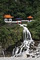
One popular spot is the Eternal Spring Shrine. It is also called the Changchun Shrine. This shrine was built to honor the 226 people who sadly died while building the highway. Two waterfalls flow out from the building, making it a beautiful sight.
Many people enjoy hiking in the park. There are lots of hiking trails to explore. Some trails start near the Eternal Spring Shrine. There is even a cave with statues inside that you can visit. The Taroko village is another important place to see in the park.
Images for kids
-
Map of Taroko area (1944)
-
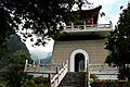
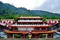
Xiangde Temple at Tianxiang
-

Bicycling uphill
-
Bicyclists share narrow roads with motor vehicles
-
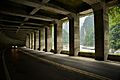
Rockfall Prevention Tunnel (明隧道)
-
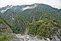
Gorge views
-
Eternal Spring Shrine, Taroko National Park, Hualien on the east coast.
-
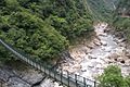
Shakadang River
-
Liwu River
-
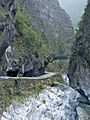
Zhuilu Suspension Bridge
-

(Shakadang) Bridge of 100 Lions
-
Changchun Bridge
-
Zhuilu Suspension Bridge (East of Zhuilu Old Road)
-
Bell Tower at Eternal Spring Shrine Trail
-

Taroko Music Festival
-
Changuang Temple
-
Taroko Gorge from Zhuilu Old Road
-
Zhuilu Tunnel from Zhuilu Old Road


.jpg)


See also
 In Spanish: Parque nacional Taroko para niños
