Tercero River facts for kids
Quick facts for kids Tercero River |
|
|---|---|

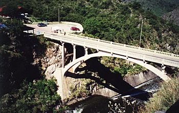
The Provincial Route 5 bridge over the Tercero River
|
|
| Argentina | Country |
| Córdoba Province | Province |
| Physical characteristics | |
| Main source | Sierras de Córdoba |
| River mouth | Carcarañá River |
| Basin features | |
| River system | Paraná River |
The Tercero River (which means 'Third River' in Spanish), also known as Ctalamochita, is an important river in Córdoba Province, Argentina. It plays a big role in the region's environment and economy.
Contents
River's Journey and Features
The Tercero River starts its journey in the Sierras de Córdoba mountains. This is near Cerro Champaquí and the Calamuchita Valley. In this area, it rains a good amount each year, between 600 and 1000 millimeters (about 24 to 39 inches).
Dams and Their Uses
As the river leaves the valley and reaches the flatter plains, it flows through four important dams. These dams are called Cerro Pelado Dam, Arroyo Corto Dam, Embalse Río Tercero, and Piedras Moras.
The Embalse Río Tercero dam was built in 1936 and created a large lake covering about 54.3 square kilometers (21 square miles). These dams help control the river's flow, preventing floods. They also produce hydroelectricity, which is electricity made from the power of moving water. The lakes formed by the dams are popular spots for fun activities like water sports, fishing, and tourism.
River Flow and Length
The Tercero River has an average water flow of about 27.17 cubic meters per second (959 cubic feet per second). It flows for about 307 kilometers (191 miles) before it joins another river.
The river is wide enough for small to medium-sized boats to travel on it, especially as it moves through the plains. It flows eastward into an area called the Humid Pampas. This region gets about 730 millimeters (29 inches) of rain each year.
The Tercero River eventually meets the Saladillo River (also known as the Cuarto River). When these two rivers join, they form the Carcarañá River. The Carcarañá River then flows into the Paraná River, which is a very large river system in South America. This means the Tercero River's water eventually reaches the Río de la Plata Basin.
Cities Along the River
Many important cities are located along the Tercero River's path. Some of these include Río Tercero, Villa María, Villa Nueva, Bell Ville, and Leones. These cities benefit from the river for water, transport, and recreation.
River's Name: Tercero or Ctalamochita?
The name Ctalamochita has an interesting history. It seems to be a mix of words. Ctala or tala is a word from Native American languages, meaning "important tree." The second part, mochita, might come from the Spanish word mucho or muchito, meaning "many." So, Ctalamochita likely means "area of many trees."
The name Tercero became more common after the 1700s. It was called "Third" because it was the third of five rivers counted from the city of Córdoba. Out of these five rivers, only the Tercero and the Cuarto (meaning "Fourth") indirectly reach the Paraná River. This makes them important parts of the larger river system.
Bridges Over the Tercero River
Many bridges cross the Tercero River, connecting different towns and areas. These bridges are important for transportation and daily life. Some of the notable bridges include:
- Piedras Moras Dam Bridge (in Almafuerte)
- 6th State Road Bridge (in Rio Tercero)
- Velez Sarsfield Bridge (in Villa Maria - Villa Nueva)
- Colon Bridge (in Bell Ville)
- Italia Bridge (in Bell Ville)
See also
 In Spanish: Río Tercero para niños
 | Lonnie Johnson |
 | Granville Woods |
 | Lewis Howard Latimer |
 | James West |

