The Palace Pier facts for kids
Quick facts for kids The Palace Pier |
|
|---|---|
 |
|
| General information | |
| Status | Complete |
| Architectural style | Late Modernist |
| Coordinates | 43°37′52″N 79°28′24″W / 43.631192°N 79.473252°W |
| Completed | 1978, 1991 |
| Technical details | |
| Floor count | 46 |
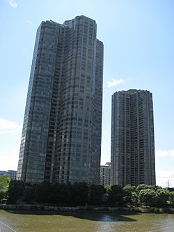
The Palace Pier is a special place in Toronto, Ontario, Canada. It's home to two tall condominium buildings called Palace Place and Palace Pier. These buildings are among the tallest in Toronto. They are located right by Lake Shore Boulevard West in the Humber Bay area, which used to be part of Etobicoke.
About the Towers
This complex has two fancy condominium towers. One is called Palace Pier (the North Tower) and the other is Palace Place (the South Tower). Even though they are separate, they stand together like a grand entrance to the west side of Toronto's waterfront. They mark the start of the Humber Bay Shores neighbourhood.
The first tower, Palace Pier (North Tower), was finished in 1978. It was designed by Edward I. Richmond. With 46 floors, it was the tallest residential building in Canada at that time!
The second tower, Palace Place (South Tower), was completed in 1991. Both towers offer amazing views. You can see the Toronto skyline, Lake Ontario, and even the towns to the west. On a clear day, you might even spot the mist from Niagara Falls!
History of the Palace Pier Site
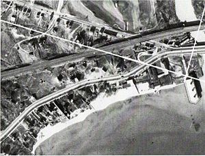
Before these tall buildings were here, this spot had a hotel called Wimbleton House in the 1860s. Later, it was known as Crow's Hotel around 1900. The beach nearby was called Crow's Beach for many years. There was even a lifeguard station here, but it disappeared when the Palace Pier complex was built.
The name "Palace Pier" comes from an old amusement pier. This pier was once planned for the same location where the towers stand today.
In 1927, there were big plans for this pier. It was going to cost $1.25 million, which was a huge amount back then! People said it would be one of the biggest landmarks on the Toronto waterfront. It was meant to be like the famous amusement piers in England, but even grander than the one in Brighton, England. The architects Craig and Madill designed it.
The plan was to build a "Palace of Fun." It would be on a pier stretching almost a third of a mile into Lake Ontario. This huge pier was supposed to have a ballroom big enough for 3,000 couples. It would also have a roller rink that could turn into an ice skating rink in winter. There were plans for a theatre with 1,400 seats, an outdoor band stage, restaurants, and souvenir shops. The pier would even have docks for large ships!
Getting money for the project was slow. The first building's foundation was laid in 1931 by former Canadian prime minister Arthur Meighen. But, like many projects during that time, it ran into money problems. In the end, only a small part of the pier was ever built.
The first part of the amusement pier, about 90 meters long, finally opened on June 10, 1941. It became a very popular dance hall during World War II. Famous Hollywood star Bob Hope even officially opened it by roller skating! As big band music became less popular, the pier hosted other events. These included boxing matches, wrestling, concerts, and high school proms.
The pier was designed in a fancy Moroccan style. The architects, Craig & Madill, were also known for building many churches and public buildings.
Sadly, the pier was destroyed by a fire in 1963. Later, the area was redeveloped into the condominium towers and a public park. Today, you can find a special plaque from 1994 near the Humber River. It marks what's left of the original Palace Pier dance hall.
The Neighbourhood
The area around the Palace Pier towers is great for outdoor activities. The Martin Goodman Trail is nearby, perfect for walking, jogging, cycling, or rollerblading. This trail is 22 kilometers long and goes through beautiful parkland. It's also part of the much longer 300-kilometer Lake Ontario Greenway Waterfront Trail.
You can find marinas and yacht clubs close by if you enjoy boating. There are also restaurants, entertainment, and cultural spots within walking distance. Getting around is easy too! The buildings are close to major highways like the Queen Elizabeth Way and Highway 427. The TTC's Humber Loop is also nearby. Plus, a grocery store, pharmacy, and liquor store are just a 10-minute walk away.
The City of Toronto Parks and Recreation Department and the Toronto and Region Conservation Authority have worked together to improve the natural environment here. They've created a new waterfront park, the Humber Bay Butterfly Habitat, and improved wetlands and fish habitats.
 | Ernest Everett Just |
 | Mary Jackson |
 | Emmett Chappelle |
 | Marie Maynard Daly |


