The Pinnacle (Cape Breton) facts for kids
Quick facts for kids The Pinnacle |
|
|---|---|
| Highest point | |
| Elevation | 530 m (1,740 ft) |
| Prominence | 71 m (233 ft) |
| Geography | |
| Location | Inverness County, Nova Scotia, Canada |
| Parent range | Cape Breton Highlands |
| Topo map | NTS 011/K10 |
| Climbing | |
| Easiest route | Hike |
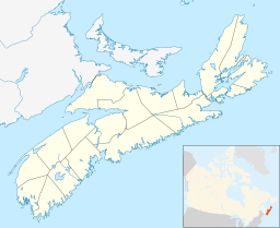
The Pinnacle is a cool mountain peak located in Canada. It's part of the beautiful Cape Breton Highlands in Nova Scotia. This peak stands tall at about 530 meters (that's about 1,739 feet) above sea level!
Guess what? The Pinnacle is the second highest spot in all of Nova Scotia. It's also the highest point in Inverness County, Nova Scotia. This makes it a really special place to visit.
You can find The Pinnacle inside the amazing Cape Breton Highlands National Park. It's part of a big, flat area called the Cape Breton Highlands plateau. The peak is about 20 kilometers (12 miles) east of a town called Cheticamp. It's also about 29 kilometers (18 miles) west of Ingonish on Cape Breton Island.
The Pinnacle has a neighbor that's almost as tall! This is the Bakeapple Barren Northeast, which is only about 5 kilometers (3 miles) away. The highest point in Nova Scotia, White Hill, is also not too far, about 13.4 kilometers (8 miles) to the east. The Pinnacle is the highest point of an area called Rocky Barren. This area is where the MacKenzies and Cheticamp rivers begin.
Exploring The Pinnacle
If you love hiking and exploring nature, The Pinnacle is a great place to visit. It offers a chance to see the stunning landscapes of Cape Breton.
How to Reach The Pinnacle
The easiest way to get close to The Pinnacle is by using a gravel road. This road is open only during certain times of the year. It leads towards Fishing Cove Lake, which is to the northwest of the peak. From there, you can start your adventure!


