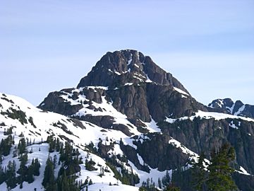
The Red Pillar facts for kids
Quick facts for kids The Red Pillar |
|
|---|---|
 |
|
| Highest point | |
| Elevation | 2,034 m (6,673 ft) |
| Prominence | 571 m (1,873 ft) |
| Geography | |
| Location | Vancouver Island, British Columbia, Canada |
| Parent range | Vancouver Island Ranges |
| Topo map | NTS 92/F11 |
The Red Pillar is a cool mountain found on Vancouver Island in British Columbia, Canada. It's about 33 kilometers (20 miles) southwest of a town called Courtenay. It's also 17 kilometers (11 miles) south of another big mountain, Mount Albert Edward.
This mountain is part of the Vancouver Island Ranges. These ranges are a group of mountains that make up part of the larger Insular Mountains chain.
Contents
Discovering The Red Pillar
The Red Pillar got its name because of how it looks! It has a distinct reddish color, especially its rocky parts. This makes it stand out from other mountains.
How The Red Pillar Got Its Name
The story of its name goes back to 1931. Two local climbers, Geoff Capes and Jack Gregson, were the first to reach the top. They left a note there, suggesting the name "The Pillar."
Later, in 1935, a man named Ben Hughes wrote a letter. He was part of the climbing group that first reached the summit. He thought "The Pillar" was a good start, but there were many other "Pillar" mountains. Since this mountain had such clear reddish rocks, he suggested adding "Red" to the name. And that's how it became "The Red Pillar"!
Getting to The Red Pillar
If you want to visit The Red Pillar, the easiest way is from the south side. You can use a path called the Ash River Trail. This trail begins near the northwest end of a lake called Oshinow Lake.
Starting Your Journey
There are two main ways to reach the start of the Ash River Trail:
- You can paddle a boat all the way across Oshinow Lake. You would start from the boat launch at the southeast end.
- Another option is to hike along an old logging road, called 110H. This road goes along the east side of Oshinow Lake, but it can be a bit rough and overgrown.
Other Ways to Reach the Mountain
You can also get to The Red Pillar from the Comox Glacier. This way involves going over or around Argus Mountain. It's a more challenging route for experienced hikers.
 | Jewel Prestage |
 | Ella Baker |
 | Fannie Lou Hamer |

