
The Thunderer (Wyoming) facts for kids
Quick facts for kids The Thunderer |
|
|---|---|

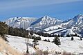
From Soda Butte
|
|
| Highest point | |
| Elevation | 10,558 ft (3,218 m) |
| Prominence | 1714 |
| Geography | |
| Location | Yellowstone National Park, Park County, Wyoming, US |
| Parent range | Absaroka Range |
| Topo map | Abiathar Peak |
The Thunderer is a tall mountain peak located in the northeast part of Yellowstone National Park. It stands at about 10,558 feet (3,218 meters) high and is part of the Absaroka Range. This mountain got its name in 1885 from a group of scientists called the Arnold Hague Geological Survey. They noticed it often attracted thunderstorms, so they called it 'The Thunderer'! Before that, people just thought it was a high ridge connected to Mount Norris. You can easily spot The Thunderer from the road as you drive through the Soda Butte Creek canyon.
Contents
Exploring The Thunderer
The Thunderer is more than just a peak; it's a long, high ridge. It sits just north of Mount Norris, another notable mountain in the area. Its impressive height makes it a landmark that can be seen from many spots in the park's northeast region.
How to Reach The Thunderer
If you're an adventurous hiker, you can explore the northern end of The Thunderer's ridge. A trail called the Thunderer Cutoff Trail leads the way. This trail is about 7.4 miles (11.9 kilometers) long.
Starting Your Hike
The start of the Thunderer Cutoff Trail is easy to find. It's located right across from the Pebble Creek Campground. This campground is on the northeast entrance road of Yellowstone National Park.
The Trail's Path
As you hike the Thunderer Cutoff Trail, you will pass through an area known as Chaw Pass. This pass connects to another trail called the Cache Creek trail. The Cache Creek trail runs alongside the southeast side of The Thunderer ridge, offering great views of the mountain.
Images for kids
-
The Thunderer (left) and Mount Norris (right)

