Titirangi facts for kids
Quick facts for kids
Titirangi
|
|
|---|---|
|
Suburb
|
|
 |
|
| Country | New Zealand |
| Local authority | Auckland |
| Electoral ward |
|
| Local board |
|
| Area | |
| • Land | 1,218 ha (3,010 acre) |
| Population
(June 2023)
|
|
| • Total | 15,440 |
|
|
||
Titirangi is a lovely suburb in West Auckland, New Zealand. It's part of the Waitākere Ranges area. This green and hilly suburb is about 13 kilometers southwest of Auckland's city center. The name "Titirangi" comes from the Māori language and means "hill reaching up to the sky."
Contents
Exploring Titirangi's Geography
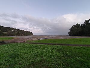
Titirangi is a unique place with beautiful nature. It sits right next to the Manukau Harbour to the south. To the west and northwest, you'll find the wild Waitākere Ranges. These ranges are covered in native bush and include large parks and areas that collect water for Auckland.
What is the Landscape Like?
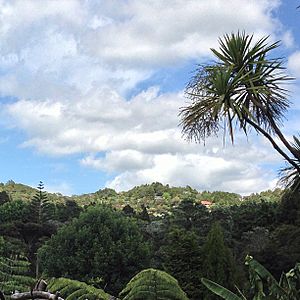
The Waitākere Ranges get a lot of rain because they are on the west coast. This helps the native bush grow thick and green. Many native birds live here, like the fantail, tūī, and kererū (wood pigeon). You might also spot morepork owls, white-eye birds, geckos, and rare native frogs.
Titirangi's landscape changes a lot. It goes from the sandy Titirangi Beach on the Manukau Harbour up to hills that are 400 meters high in the Waitākere Ranges.
Discovering Local Walks and Views
Mt Atkinson is a hill near the village center. It used to be called Bishop's Hill. You can take a short walk there and enjoy amazing views of Titirangi Village and both the Manukau and Waitemata harbours.
Another path is the 'Zig Zag Track'. This walk goes through native bush from the village center down to Titirangi Beach. If you like longer walks, Exhibition Drive is a popular track for walking, jogging, and cycling. It's about 1.5 kilometers from the village center.
A Look at Titirangi's History
Titirangi has a rich history, especially with the Te Kawerau ā Maki people. They are an iwi (tribe) who have lived in the Auckland Region for a very long time.
How Did Titirangi Get Its Name?
The name Tītīrangi was chosen by Rakataura, a wise leader from the Tainui canoe. He named the area after a hill in his homeland. The name means "hill reaching up to the sky." It can also mean "long streaks of cloud in the sky" or "fringe of heaven."
Early European Settlement and Logging
In the mid-1800s, the Manukau Harbour shoreline was used for logging kauri trees. These huge trees were cut down for their wood by early settlers. Most of the kauri forests were harvested by this time.
John Kelly was the first landowner in Titirangi in 1848. By the 1860s, much of Titirangi became farmland. People living in the southern parts of Titirangi often traveled by boat on the Manukau Harbour to connect with other towns.
Building Dams and Roads
In 1902, a wooden dam was built to help supply Auckland with water. This was the start of the Upper Nihotupu Dam. Water was piped from the dam to Titirangi and then to Auckland City. The dam was fully finished in 1923.
Titirangi was mostly farmland until World War I. After the war, many farm workers left, and native plants started to grow back. The Titirangi village grew a lot in the 1910s. This was because workers building Scenic Drive (then called Exhibition Drive) needed places to stay. Exhibition Drive opened in 1914.
In the early 1900s, beaches like Wood Bay and French Bay became popular places for people from Auckland to visit.
The Hotel and Artists' Homes
In 1930, the Hotel Titirangi opened. It's now known as Lopdell House. It was a modern hotel, but it closed quickly because it couldn't get a license to sell alcohol.
As roads got better in the 1960s, Titirangi became more of a suburban area. Famous artist Colin McCahon lived in Titirangi in the 1950s. He painted many artworks inspired by the local landscape. His former house, McCahon House, is now a place where artists can live and work. Many other New Zealand artists have stayed there.
Important Historic Buildings
- Lopdell House
- Titirangi Soldiers' Memorial Church
Understanding Titirangi's Community
Titirangi is home to many people. As of 2023, the estimated population was about 14,856 people. The community is diverse, with many different cultures living together. Most people speak English, but other languages are also spoken.
Exploring Titirangi's Culture
Titirangi is known for its unique houses built among the native bush of the Waitākere Ranges. Many homes have great views of the Manukau Harbour. Some houses are even built on poles to protect the tree roots around them.
Arts and Creativity in Titirangi
Titirangi has a reputation for being a place where artists and creative people live. Many famous New Zealand musicians, artists, writers, and potters have lived here. These include singer/songwriter Tim Finn and author Maurice Shadbolt. The former home of painter Colin McCahon is now a museum and a place for artists to stay.
The Titirangi Roundabout Sculpture
A special sculpture sits on the roundabout where several main roads meet in Titirangi. It was designed by a student artist in 1993. It was meant to be there for only five years, but it has stayed permanently and become a symbol of Titirangi. Its color was changed from pink to a teal green in 2009.
Local Arts and Activities
In the historic Lopdell House, you can find a local theatre, a cinema, a community art gallery, and a radio station. Next door is Te Uru Waitakere Contemporary Gallery, which is West Auckland's main art gallery. Many short walks or longer tramps in the Waitakeres start from Titirangi.
Learning in Titirangi
Titirangi School is a primary school for students in years 1-6. It has a long history, going back to around 1845.
For older students, the nearest secondary schools are Green Bay High School, Kelston Boys' High School, and Kelston Girls' College.
Titirangi's Unique Biodiversity
Titirangi is home to a special New Zealand moth species called Hierodoris huia. This moth has only been found in Titirangi and was named after Huia Road, a local street.
 | James Van Der Zee |
 | Alma Thomas |
 | Ellis Wilson |
 | Margaret Taylor-Burroughs |


