
Tmutarakan facts for kids

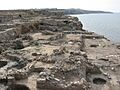
Excavation at the site, September 2008
|
|
.svg)
Location in Krasnodar Krai
.svg)
Location in European Russia
|
|
| Alternative name | Hermonassa |
|---|---|
| Location | Krasnodar Krai, Russia |
| Region | Taman Peninsula |
| Coordinates | 45°13′09″N 36°42′51″E / 45.21917°N 36.71417°E |
| Type | Settlement |
| History | |
| Founded | 6th century BCE |
| Abandoned | After 14th century CE |
| Site notes | |
| Condition | In ruins |
Tmutarakan was an important trading town and a small kingdom (called a principality). It was part of Kievan Rus', an early East Slavic state. This town was very important because it controlled a key water passage. This passage connected the Black Sea to the Sea of Azov. Tmutarakan was active from the late 900s to the late 1000s.
Before it was Tmutarakan, the site was an ancient Greek city called Hermonassa. Greek settlers founded Hermonassa in the mid-500s BCE. It was located on the Taman Peninsula in what is now Krasnodar Krai, Russia. Later, in the 600s CE, the Khazar people built a fortress there. They called it Tamantarkhan. When Kievan Rus' took control, the name changed to Tmutarakan.
Contents
A Look at Tmutarakan's Past
The Greek city of Hermonassa was close to other big trade centers. These centers were Phanagoria and Panticapaeum. People from Mytilene, an island called Lesbos, founded Hermonassa. This happened around 550 BCE. There is also proof that people from Crete helped build the city.
Hermonassa grew and became very successful for hundreds of years. Scientists have dug up many old buildings and streets from this time. They also found a collection of golden coins from the 300s BCE. Hermonassa was a center for worshipping the goddess Aphrodite. In the early centuries CE, the city traded with the Alans. Around 200 CE, the city was rebuilt and planned out again.
From Greek City to Khazar Fortress
After being a Roman ally for a long time, the Bosporan Kingdom fell. The Huns defeated the Alans nearby in 375 or 376 CE. When the Hunnic Empire ended in the late 400s, the area returned to Roman influence. But then the Bulgars took control in the 500s.
In the late 600s, the city was taken by the Khazars. They rebuilt it as a strong fortress town. They renamed it Tamatarkha. Arab writers called it Samkarsh al-Yahud. This means "Samkarsh of the Jews." It showed that Jewish merchants did a lot of the trading there. Other names for the city were "Samkersh" and "Samkush."
Tamatarkha was a large city with many merchants. It had strong brick walls and a good harbor. It controlled much of the trade between Northern Europe and the Byzantine Empire. It also connected to the Northern Caucasus region. Trade routes also went southeast to Armenia and Muslim lands. Other routes linked to the famous Silk Road in the east. Many different people lived in Tamatarkha. These included Greeks, Armenians, Rus', Jews, Ossetians, Lezgins, Georgians, and Circassians.
Even after the Khazar empire was destroyed in the mid-900s, Khazars still lived in the area. A Hebrew letter from 985–986 CE mentions "our lord David, the Khazar prince." He lived in Taman. Envoys from Kievan Rus' visited him to ask about religious matters.
Tmutarakan in Medieval Times

We don't know the exact date Kievan Rus' took over Tmutarakan. But the Hypatian Codex, an old record, mentions it. It says that Vladimir the Great gave Tmutarakan to his sons. This means Rus' control began in the late 900s. It was definitely before Vladimir died in 1015. The new rulers even made their own bronze and silver coins. These coins looked like Byzantine money.
Princes and Power Struggles
Vladimir's son, Mstislav of Chernigov, was the prince of Tmutarakan in the early 1000s. During his rule, the first stone church was built. It was dedicated to the Mother of God. Digs show that Byzantine workers built it. It looks similar to a church Mstislav later built in Chernigov.
After Mstislav died, several princes ruled Tmutarakan for short times. Gleb Svyatoslavich was given control by his father, Svyatoslav Yaroslavich. But in 1064, a rival prince, Rostislav Vladimirovich, took his place. Rostislav then had to flee when Gleb returned with an army. But once Svyatoslav left, Rostislav kicked Gleb out again.
During his short rule, Rostislav took control of the local Circassians and other tribes. This made the nearby Greek city of Chersonesos in Crimea suspicious. Their Byzantine envoy poisoned Rostislav on February 3, 1066.
After this, control of Tmutarakan went to the prince of Chernigov. Then it went to the Grand Prince of Kiev, Vsevolod Yaroslavich. In 1079, Svyatoslav Yaroslavich appointed a governor (called a posadnik). But two years later, David Igorevich and Volodar Rostislavich captured him. They then took over the city.
Oleg Svyatoslavich had been exiled to Byzantium by Khazar agents. He returned to Tmutarakan in 1083. He drove out the people who had taken over. Oleg took the title "archon of Khazaria." This meant he put the city under Byzantine control in name only. But he also made his own silver coins. These coins had a short message in Cyrillic letters. Then, in 1094, Oleg returned to Rus' to claim the throne of Chernigov.
Byzantine Interest
The Byzantine Empire kept an eye on Tmutarakan. They had a very important reason. There were naphtha deposits in the area. Naphtha was a key ingredient for their main weapon, Greek Fire. This was a special burning liquid. Until the late 1100s, the Byzantine leaders did not let their Genoese trading partners go to the city. The Genoese knew it as Matracha.
Tmutarakan's Decline

In the 1200s, Tmutarakan became part of the Empire of Trebizond. This was a state that came after the Byzantine Empire. The last time Tmutarakan was mentioned in records was in 1378. In the 1300s, the area came under the control of the Republic of Genoa. It was part of their trading area called Gazaria. This area was based in Kaffa.
The Ghisolfi family managed this territory. In 1482, the Crimean Khanate conquered it. Then, in 1791, Russia took control. There might have been a Khazar connection still. Records mention "Jewish princes" in Tamatarkha under both Genoese and Tatar rule.
The city eventually fell into ruins. It was rediscovered in 1792. A local farmer found a stone with an inscription. It said that Prince Gleb had measured the sea from here to Kerch in 1068. Scientists started digging at the site in the 1800s. These digs have continued since then. In some places, the layers of old settlements are more than twelve meters deep.
During the 1600s and 1700s, Cossacks controlled the area. Their main town was Taman. This town was near the remains of Tmutarakan. The modern town of Temryuk is also nearby.
What's in a Name?
People have wondered how Tmutarakan got its later name. Most think it comes from the Tatar language. One historian, Jean Richard, also mentioned a Greek word for "fish curing." This was an important product from the Black Sea. Later, the Russian people might have changed the name to sound like Russian words. It could have combined t'ma ("darkness") and tarakan ("cockroach"). This would make it mean something like 'the middle of nowhere' or 'the back of beyond'. The poet Vladimir Mayakovsky used it with this meaning.
Images for kids
-
Excavation at the site, September 2008
