Toolibin Lake facts for kids
Quick facts for kids Toolibin Lake |
|
|---|---|
| Location | Wheatbelt, Western Australia |
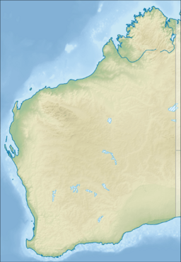
| Coordinates | 32°55′15″S 117°36′28″E / 32.92083°S 117.60778°E |
| Type | perched freshwater or brackish wooded swamp |
| Primary inflows | local surface runoff |
| Primary outflows | overflows into other wetlands in the headwaters of the Arthur River |
| Catchment area | Upper Blackwood River |
| Basin countries | Australia |
| Max. length | 2 km (1.2 mi) |
| Max. width | 1.7 km (1.1 mi) |
| Surface area | 3 km2 (1.2 sq mi) |
| Max. depth | 2 m (6 ft 7 in) |
| Surface elevation | 300 m (980 ft) |
| Designated: | 7 June 1990 |
| Reference #: | 483 |
Toolibin Lake is a special lake in Western Australia. It is a seasonal lake, meaning it holds water only at certain times of the year. Sometimes it has fresh water, and sometimes it has slightly salty water, called brackish water.
The lake is a perched lake, which means it sits above the main underground water level. It is also a wooded swamp, full of trees. Toolibin Lake is part of a 493-hectare (1,218-acre) nature reserve. You can find it about 200 kilometres (124 mi) south-east of Perth. It is also about 40 kilometres (25 mi) east of Narrogin in the Wheatbelt region. The Australian Government lists Toolibin Lake as a threatened ecological community. This means its unique plants and animals are at risk.
Contents
Discover Toolibin Lake's Features
Toolibin Lake is located in the upper part of the Blackwood River area. It sits about 300 metres (984 ft) above sea level. The lake covers about 300 hectares (740 acres) and is 2 kilometres (1.2 mi) wide. It can be up to 2 metres (6.6 ft) deep.
This lake is one of the last remaining freshwater lakes in south-western Australia. It is part of a series of wetlands in an old river valley. Most of the lake is covered with trees that like water. There is also a large open area on the eastern side. Many other wetlands in the Wheatbelt used to be like Toolibin Lake. But, clearing land for farming made most of them salty. This caused them to lose their plants. Toolibin is the only big lake in this area that has not become completely salty.
Water Levels at Toolibin Lake
Toolibin Lake is in a dry part of the Wheatbelt. It gets about 400 mm of rain each year, mostly from May to August. But, about 1800 mm of water evaporates each year. This means the lake usually only holds water at certain times. Sometimes it dries out completely for years. Other times, it can hold water for a long time.
Toolibin Lake: A Ramsar Wetland
Toolibin Lake is very important. It is recognized as a wetland of international importance. This recognition comes from the Ramsar Convention on Wetlands. It was named Ramsar Site 483 on June 7, 1990. The Ramsar site includes the whole lake. It also includes some land around the lake. This extra land was added in 2001. It creates a buffer zone of at least 100 m around most of the lake. This buffer helps protect the lake.
Explore Toolibin Lake's Wildlife
Toolibin Lake is the only place left in Southwest Australia with many living swamp sheoak trees. It also has paperbark trees called Melaleuca strobophylla. These trees grow on the edges and bed of the lake. They were common in wetlands before farming started.
On higher ground around the lake, you can find other trees. These include flooded gum, acorn banksia, and rock sheoak. The lake also has plants that grow underwater and sedges around its edges.
Animals Living at Toolibin Lake
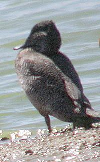
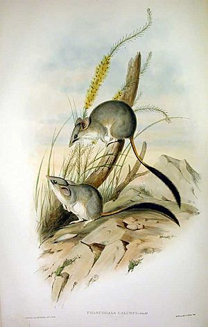
The plants at Toolibin Lake create a rare home for many animals. This is especially true for woodland birds. Toolibin Lake and its surroundings support many types of waterbirds. Up to 25 different species breed here. These include the rare freckled duck. You can also see cormorants, egrets, night herons, and spoonbills. More waterbirds breed here than at any other inland wetland in south-western Australia. The lake is also home to the threatened red-tailed phascogale.
Protecting Toolibin Lake
Toolibin Lake faces several threats. The main problems are salinisation and waterlogging. Salinisation means the water is getting too salty. Waterlogging means there is too much water in the soil. These problems happen because land was cleared for farming. Farms grow wool and cereal grains.
Another threat is eutrophication. This happens when too many nutrients from farm fertilizers run into the lake. Invasive species are also a problem. These are plants and animals that are not native to the area. They can change the ecosystem and reduce food and shelter for native animals. Finally, kangaroos, livestock, and rabbits eat young plants. This stops new plants from growing.
Helping Toolibin Lake Recover
People are working to help Toolibin Lake. They want to restore its natural environment. One way is to reduce the amount of water soaking into the ground. This includes planting more trees and protecting existing ones. Farmers are also changing their methods. They use contour farming, which means plowing along the curves of the land. They also use perennial grasses for grazing.
Another effort is to manage surface water. This helps reduce waterlogging on farms. It also makes the water entering the lake less salty. This lowers the salt in the lake. Pumping groundwater from beneath the lake also helps. This lowers the water table and protects the lake.
 | John T. Biggers |
 | Thomas Blackshear |
 | Mark Bradford |
 | Beverly Buchanan |


