Tornadogenesis facts for kids

Tornadogenesis is the scientific word for how a tornado forms. Tornadoes are powerful spinning columns of air that touch both the ground and a storm cloud. There are different kinds of tornadoes, and they don't all form in the exact same way. Even with lots of scientific study, like the VORTEX projects, how tornadoes start is still a bit of a mystery.
A tornado happens when air that is already spinning (called vorticity) gets stretched and pulled together. This makes the spin much faster and tighter, creating a strong vortex. Most tornadoes go through a life cycle: they form, grow stronger, and then fade away. Scientists are very interested in how tornadoes form, how long they last, and how strong they get. They also study how tornadoes disappear, a process sometimes called tornadolysis.
Contents
How Supercell Tornadoes Form
The most well-known tornadoes are those that come from powerful thunderstorms called supercells. These storms have a special way of forming tornadoes.
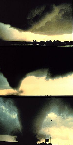
The process starts when a strong thunderstorm develops a spinning area of air a few miles up in the atmosphere. This spinning part is called a mesocyclone. As rain falls in the storm, it pulls down a fast-moving area of air known as the rear flank downdraft (RFD). This downdraft speeds up as it gets closer to the ground, pulling the spinning mesocyclone down with it.
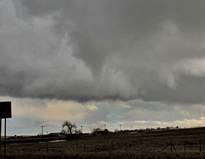
As the mesocyclone gets lower, it starts to pull in cool, moist air from the downdraft. When this cool air mixes with the warm, rising air in the storm, it forms a rotating wall cloud that you can see under the main cloud. The RFD also helps focus the mesocyclone's spin, making it pull air from a smaller area on the ground. As the storm's updraft (rising air) gets stronger, it creates an area of low pressure near the surface. This low pressure pulls the focused mesocyclone down, forming a visible funnel cloud.
When the funnel cloud reaches the ground, it officially becomes a tornado and starts causing damage. This usually happens within a few minutes of the RFD hitting the ground. Scientists have learned that certain conditions, like the temperature of the air in different parts of the storm, play a role in whether a supercell will produce a tornado.
While some people imagine tornadoes forming from the top down (from the cloud to the ground), scientists are finding more and more evidence that many tornadoes actually start forming near the ground, or even at the same time from the ground up to the cloud.
Other Types of Tornadoes
Not all tornadoes come from supercells. Some form in different ways and are often weaker.
Waterspouts
A waterspout is simply a tornado that forms over water. Most waterspouts are much weaker than supercell tornadoes. They usually form in areas with lots of moisture and not much change in wind direction with height. They often appear where winds come together, like near coastlines or over large lakes.
Waterspouts usually develop as their parent clouds are still growing. Scientists believe they start spinning from horizontal air movement near the water's surface. This spin then stretches upwards into the developing cloud. The cloud they form from can be a simple cumulus cloud or a stronger thunderstorm.
Landspouts
Landspouts are tornadoes that form over land but are not from supercells. They look and act a lot like the weaker waterspouts. They are thought to form when a growing cloud's updraft pulls in and tightens existing spinning air near the ground.
Small Swirls and Tornadoes
Sometimes, smaller spinning areas, called mesovortices or mini-swirls, can lead to tornadoes.
Squall Line Tornadoes
Tornadoes can sometimes form within lines of thunderstorms called squall lines. This happens most often in places that are in the middle latitudes (not too close to the equator or the poles). Sometimes, even supercells can be hidden within these squall lines and produce tornadoes.
Tropical Cyclone Tornadoes
Strong tropical cyclones, like hurricanes, can also produce tornadoes. These often form from small swirls within the storm's eyewall (the ring of strong thunderstorms around the center). Tornadoes can also form in the outer rainbands of these powerful storms.
Fire Whirls
Most spinning columns of air caused by fires or volcanic eruptions are not true tornadoes. However, very rarely, the spinning air from large wildfires or eruptions can connect with a cloud base. In extremely rare cases, a special type of cloud called a pyrocumulonimbus cloud can form with a spinning mesocyclone, leading to a true tornado.
See also
- Cyclogenesis
- Convective storm detection


