Totonicapán Department facts for kids
Quick facts for kids
Totonicapán Department
Departmento de Totonicapán
|
|||
|---|---|---|---|
|
|||

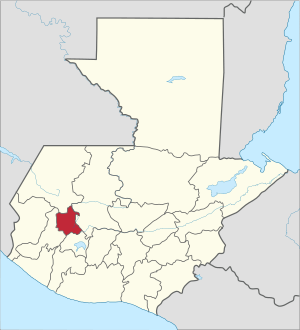
Location of the Totonicapán Department in Guatemala
|
|||
| Country | |||
| Capital | Totonicapán | ||
| Municipalities | 8 | ||
| Government | |||
| • Type | Departmental | ||
| Area | |||
| • Department | 1,061 km2 (410 sq mi) | ||
| Population
(2018)
|
|||
| • Department | 418,569 | ||
| • Density | 394.50/km2 (1,021.8/sq mi) | ||
| • Urban | 204,938 | ||
| • Ethnicities | K'iche' people Ladino | ||
| • Religions | Roman Catholicism Evangelicalism Maya | ||
| Time zone | UTC-6 | ||
| ISO 3166 code | GT-TO | ||
Totonicapán is a special area in Guatemala called a department. It is located in the western highlands of the country. The main city and capital of this department is also named Totonicapán.
Contents
What is a Department?
A department in Guatemala is like a state or province in other countries. It is a major way to divide the country for government and organization. Each department has its own capital city, which is the center for its activities.
Geography and Climate
Totonicapán Department covers an area of about 1,061 square kilometers. This makes it one of the smaller departments in Guatemala. It is known for its cool climate because it is located in the high mountains. The air is often fresh and crisp here.
Mountainous Landscape
The department has many hills and mountains. This makes the scenery very beautiful. The high elevation means it can get quite cold, especially at night. This climate is good for growing certain crops.
People and Culture
In 2018, about 418,569 people lived in Totonicapán. Many people here belong to the K'iche' people, who are an indigenous group of Guatemala. There are also Ladino people, who are of mixed heritage.
Languages and Traditions
The main language spoken is Spanish. However, many K'iche' people also speak the K'iche' language. The department is rich in traditional culture. People often wear colorful traditional clothing. They also celebrate many local festivals.
Religion in Totonicapán
Most people in Totonicapán follow Roman Catholicism. There are also many Evangelical Christians. Some people still practice traditional Maya beliefs. These different beliefs often mix together in unique ways.
Economy and Activities
The people of Totonicapán mostly work in farming. They grow crops like corn, beans, and potatoes. Many also create beautiful handmade crafts. These crafts include pottery, textiles, and wooden items.
Famous Crafts
Totonicapán is especially famous for its traditional textiles. These are fabrics woven with bright colors and patterns. They are often used to make clothing and blankets. Many families pass down their weaving skills through generations.
Municipalities
The Totonicapán Department is divided into eight smaller areas called municipalities. Each municipality has its own local government. The capital city, Totonicapán, is one of these municipalities.
- Momostenango
- San Andrés Xecul
- San Bartolo
- San Cristóbal Totonicapán
- San Francisco El Alto
- Santa Lucía La Reforma
- Santa María Chiquimula
- Totonicapán
See also
 In Spanish: Departamento de Totonicapán para niños
 | DeHart Hubbard |
 | Wilma Rudolph |
 | Jesse Owens |
 | Jackie Joyner-Kersee |
 | Major Taylor |


