Trail, Oregon facts for kids
Quick facts for kids
Trail, Oregon
|
|
|---|---|

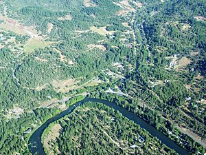
An aerial image of Trail and the Rogue River
|
|
| Country | United States |
| State | Oregon |
| County | Jackson |
| Area | |
| • Total | 6.88 sq mi (17.83 km2) |
| • Land | 6.80 sq mi (17.62 km2) |
| • Water | 0.08 sq mi (0.21 km2) |
| Elevation | 1,430 ft (440 m) |
| Population
(2020)
|
|
| • Total | 768 |
| • Density | 112.91/sq mi (43.59/km2) |
| Time zone | UTC-8 (Pacific (PST)) |
| • Summer (DST) | UTC-7 (PDT) |
| ZIP code |
97541
|
| FIPS code | 41-74400 |
| GNIS feature ID | 1151362 |
Trail is a small place in Jackson County, Oregon, United States. It's called a census-designated place because it's a community that the government counts for population, but it's not officially a city or town with its own local government. It's also an unincorporated community, meaning it's not part of any city.
As of the 2020 census, about 768 people lived in Trail. It has its own post office with the ZIP code 97541. Trail is located where two roads, Oregon Route 227 and Oregon Route 62, meet. It's just north of Shady Cove and west of Lost Creek Lake. This lake is a reservoir, which is like a big storage area for water, from the Rogue River. Trail is also found near where Trail Creek flows into the Rogue River.
People Living in Trail
This section tells us about the number of people who live in Trail. This information comes from official government counts called censuses.
| Historical population | |||
|---|---|---|---|
| Census | Pop. | %± | |
| 2020 | 768 | — | |
| U.S. Decennial Census | |||
Weather and Climate
Trail has a type of weather known as a warm-summer Mediterranean climate. This means it has warm, dry summers. The average monthly temperatures in summer don't get super hot, staying below 71.6 degrees Fahrenheit (22 degrees Celsius). The winters are usually mild and wet.
See also
 In Spanish: Trail (Oregón) para niños
 | Victor J. Glover |
 | Yvonne Cagle |
 | Jeanette Epps |
 | Bernard A. Harris Jr. |


