
Lost Creek Lake facts for kids
Quick facts for kids Lost Creek Lake |
|
|---|---|

The lake behind William L. Jess Dam
|
|

Lost Creek Lake
Location in Oregon

Lost Creek Lake
Location in the United States
|
|
| Location | Jackson County, Oregon |
| Coordinates | 42°40′59″N 122°39′17″W / 42.68306°N 122.65472°W |
| Type | reservoir |
| Primary inflows | Rogue River |
| Primary outflows | Rogue River |
| Catchment area | 674 sq mi (1,750 km2) |
| Basin countries | United States |
| Max. length | 10 mi (16 km) |
| Surface area | 3,430 acres (13.9 km2) (full pool) |
| Water volume | 315,000 acre⋅ft (389×106 m3) |
| Shore length1 | 30 mi (48 km) |
| Surface elevation | 1,751 to 1,872 ft (534 to 571 m) |
| 1 Shore length is not a well-defined measure. | |


Lost Creek Lake is a large reservoir (an artificial lake) located on the Rogue River in Jackson County, Oregon, United States. The lake was created by the William L. Jess Dam, which was built by the U.S. Army Corps of Engineers in 1977. The main reasons for building the dam were to control floods and help fish populations.
Lost Creek Lake and its dam were the first parts of a bigger plan called the Rogue River Basin Project. This project also includes Applegate Lake and the Elk Creek project. The lake is about 27 miles northeast of Medford.
Contents
Building the Dam: A Look Back
Construction of the Lost Creek Dam started in 1972 and was finished in 1977. In 1996, the Congress decided to rename the dam and its nearby water intake structure. They named it after William L. Jess. He was one of the people who started the Rogue Basin Association in 1955. Jess strongly believed that the lake's water should be used for many different purposes.

The dam's main job is to control floods. It works together with Applegate Dam to manage how much water flows down the river. It also stores water for use during the summer. The dam is an earthfill structure, meaning it's made mostly of earth and rock. It has a special spillway with gates and two hydroelectric units. These units can produce a total of 49 megawatts of electricity, which is enough to power many homes!
A cool feature of the dam is its special intake tower. This tower can mix water from different depths of the lake. This helps control the water temperature before it's released downstream. By cooling the normally warm summer water of the Rogue River, it creates better conditions for fish to travel and survive. The dam is about 3,750 feet long and 327 feet high. Its top sits about 1,882 feet above sea level. The river below the dam is a popular spot for easy rafting and tubing in the summer. Joseph H. Stewart State Recreation Area is located along the lake's southern shore, and Casey State Park is on the Rogue River below the dam.
Fun Activities at Lost Creek Lake
Lost Creek Lake is located 37 miles northeast of Medford, Oregon, right off Highway 62. Since it was built in the 1970s, the lake has been a favorite spot for people in southern Oregon to have fun outdoors. There's something for everyone, whether you love water sports or land adventures!
When there's enough rain, the lake covers about 3,430 acres and can be 280 feet deep. This huge area is perfect for summer water sports like boating, water skiing, wakeboarding, tubing, and jet-skiing. Lost Creek Lake is also a popular place to fish all year round for trout and smallmouth bass.
If you enjoy hiking or mountain biking, there's a 20-mile trail that runs along the lake's shore. This trail goes through Joseph H. Stewart State Park, which is a great place to camp. The park has over 150 campsites with electricity for RVs and campers, plus 50 tent sites with water. You'll also find public bathrooms, showers, and an RV dump station at the campground.
There are two boat ramps on the lake, and one is part of Joseph H. Stewart State Park. This park's boat ramp is right next to the Lost Creek Marina. At the marina, you can store your boat, rent one, fill up on gas, buy bait and fishing gear, and even grab a snack or a meal at the small store and restaurant.
You can find all the rules and information about fishing at the Oregon Department of Fish and Wildlife website.
Cole Rivers Fish Hatchery
The Cole Rivers Hatchery is a special place located on the Rogue River, about 30 miles northeast of Medford, Oregon, on Highway 62. It's about half a mile downstream from Lost Creek Dam and sits at an elevation of 1,545 feet above sea level. The hatchery covers 58 acres of land.
The U.S. Army Corps of Engineers built this hatchery in 1973. Its purpose is to help make up for the areas where salmon usually lay their eggs and raise their young, which were blocked by the construction of the Lost Creek, Applegate, and Elk Creek Dams (though the Elk Creek Dam was never built).
The hatchery was named to honor Cole M. Rivers, a biologist who worked on the Rogue River for 20 years. This facility is used to collect adult fish, help them lay eggs, incubate the eggs, and raise young fish. They work with several types of salmon and trout, including spring Chinook, Coho, summer steelhead, winter steelhead, fall Chinook, and rainbow trout.
Images for kids
-
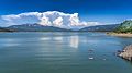
Storm clouds build near Crater Lake in the distance, and reflect in the waters of Lost Creek Lake, Oregon.
-
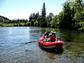
Rafters start their float down the Rogue River from McGregor Park boat ramp.
-
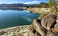
North Shore Lost Creek Lake.
-
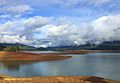
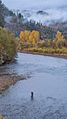
Lost Creek Lake in fall.
-
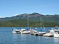
Stewart State Park marina.
-
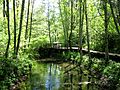
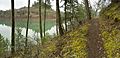
McGregor Park nature trails.
-
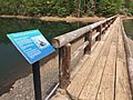
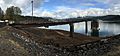
Walkway on Lost Creek Lake.
-
Rogue Nature Center at McGregor Park in fall.
-
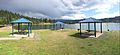
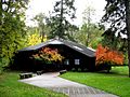
Takelma Day Use Area picnic shelters.
-
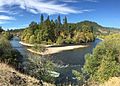
The Rogue River bends around McGregor Park.
-
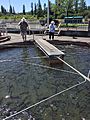
Feeding fish at the Cole M. Rivers fish hatchery.
-
Rogue River Trail and lake.
-
Intake tower at low water.
-

Fall fly fishing downstream of Lost Creek Lake
-
A fly fisherman downstream of Lost Creek Lake
-
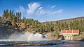
Spring at the Lost Creek Lake powerhouse.
-

Snow falls at the Lost Creek powerhouse on the Rogue River.


.jpg)
.jpg)


