Transportation in Williamsburg, Virginia facts for kids
Williamsburg, Virginia, is a city with many ways to get around! Whether you're flying in, driving, or taking a bus or train, Williamsburg has lots of options. It even has special areas where cars aren't allowed, making it great for walking and biking.
Contents
Flying to Williamsburg: Airports Nearby
Williamsburg is served by a few airports, making it easy to fly in.
Newport News/Williamsburg International Airport
The closest airport is the Newport News/Williamsburg International Airport. It's about 20 miles away in Newport News. This airport is convenient for travelers heading to Williamsburg.
Larger Airports for More Flights
If you need more flight options, two bigger airports are about 55 miles away:
- The Norfolk International Airport
- The Richmond International Airport
Both of these airports offer many more flights. Even though Richmond is about the same distance, it can sometimes be a faster drive because you avoid heavy traffic near the Hampton Roads Bridge-Tunnel.
Williamsburg Jamestown Airport: For Smaller Planes
There's also a smaller airport called the Williamsburg Jamestown Airport. It's about 3 miles southwest of Williamsburg. This airport is mainly for general aviation, which means it's used by personal planes and charter flights. It also offers services like fuel and car rentals.
Driving Around Williamsburg: Highways and Roads
Williamsburg is connected to many important roads, making it easy to reach by car.
Major Highways Connecting the City
The city is right next to Interstate 64 and U.S. Route 60. These roads link Williamsburg to:
Local Roads Around Williamsburg
- State Route 199, also called the Humelsine Parkway, goes around the city in a semicircle.
- State Route 5 connects Williamsburg to historic James River Plantations and Richmond.
- State Route 31 takes you to Jamestown and the Jamestown Ferry, which is a free boat ride across the river.
The Colonial Parkway: A Scenic Drive
The Colonial Parkway is a special road that connects the three main parts of the Historic Triangle:
This parkway is a beautiful, low-speed road. It even goes under the historic part of Colonial Williamsburg through a tunnel. Big trucks and commercial vehicles are not allowed on this scenic road.
Public Transportation in Williamsburg
Williamsburg has great public transportation options for both visitors and people who live there.
Williamsburg Transportation Center: The Main Hub
The Williamsburg Transportation Center is a central spot for all kinds of travel. It's located very close to:
- The Historic Area of Colonial Williamsburg
- The College of William and Mary
- The downtown area
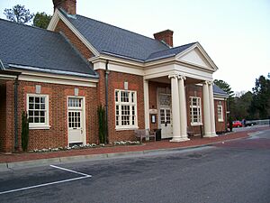
This center is in a beautifully restored building that used to be a train station. It makes it easy to get to the Colonial Williamsburg Visitor's Center. Most long-distance and local bus and train services use this center.
Train Travel: Amtrak Services
Williamsburg is served by several Amtrak trains every day. You can take a direct train to:
- Newport News
- Richmond
- Cities along the Northeast Corridor, like Washington D.C., New York City, and Boston
There are also plans to study a high-speed rail connection in Richmond that would link to both the Northeast Corridor and the Southeast High Speed Rail Corridor.
Long-Distance Bus Services
You can also travel to and from Williamsburg by long-distance bus. Services are provided by:
- Greyhound Lines (which includes Carolina Trailways)
- Hampton Roads Transit (HRT)
Local Bus System: WATA
The local public bus system is called the Williamsburg Area Transit Authority (WATA). Its main hub is at the Transportation Center. WATA buses serve:
- The city of Williamsburg
- James City County
- Most parts of York County near Williamsburg
Buses run hourly seven days a week, and every half-hour on weekdays during busy times. WATA also has a bus route that goes around the College of William and Mary campus when classes are in session. They even have special trolley-like buses at the Yorktown Riverfront attraction.
WATA connects with the larger Hampton Roads Transit (HRT) bus system at two points:
- Lee Hall in Newport News
- The Williamsburg Transportation Center
HRT routes can take you to many other cities in the Hampton Roads area.
Walking and Biking in Williamsburg
Williamsburg is a very friendly city for walkers and bikers!
Walking Around Town
Many people in Williamsburg choose to walk. In fact, about one-fifth of people walked to work between 2006 and 2010. Websites that measure how easy it is to walk in a city describe Williamsburg as "very walkable."
In the historic area, especially on Duke of Gloucester Street, cars are usually not allowed. This makes it a safe and pleasant place to walk and explore the shops and historic sites. There are bus stops and parking areas conveniently located nearby.
Biking in Williamsburg
The city is also becoming more and more bicycle-friendly. Since 1992, Williamsburg has built 48 miles of special paths and facilities for bikes.
A big project called the Virginia Capital Trail is being built. When it's finished, it will be a paved path just for bikes and walkers that goes all the way to Richmond, partly along the Colonial Parkway.


