Traveler Mountain facts for kids
Quick facts for kids Traveler Mountain |
|
|---|---|

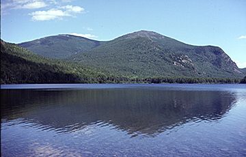
Traveler Mountain, from Lower South Branch Pond, to the northwest
|
|
| Highest point | |
| Elevation | 3,540 ft (1,080 m) |
| Prominence | 2,346 ft (715 m) |
| Listing | New England Fifty Finest #22 |
| Geography | |
| Topo map | USGS The Traveler |
Traveler Mountain is a tall mountain located in Piscataquis County, Maine. It is found inside Baxter State Park, a beautiful wilderness area. This mountain is very special because it is the eighth most "prominent" mountain in Maine.
Being "prominent" means it stands out a lot from the land around it. Think of it as how much higher it is than the lowest point connecting it to any taller mountain. Traveler Mountain has other smaller peaks nearby. These include the Peak of the Ridges, which is about 3,225 feet (983 meters) high. There are also North Traveler Mountain (3,144 feet or 958 meters) and South Traveler Mountain (2,677 feet or 816 meters).
Contents
Exploring Traveler Mountain
Traveler Mountain is part of a large area where water collects and flows. This area is called a watershed. All the rain and snow that falls on the mountain eventually flows into the Penobscot River. This river then travels all the way to Penobscot Bay on the coast of Maine.
Rivers and Waterways
Water from the east side of Traveler Mountain flows into the East Branch of the Penobscot River. On the north and west sides, water goes into several small streams. These streams then join Trout Brook. Trout Brook flows into Grand Lake Matagamon, which is where the East Branch of the Penobscot River begins. Water from the south side of the mountain flows into Pogy Brook. This brook then joins Wassataquoik Stream before reaching the East Branch of the Penobscot River.
How Traveler Mountain Got Its Name
The mountain got its name from loggers who worked on the East Branch of the Penobscot River. As they traveled down the river, the mountain seemed to move along with them in the distance. It looked like it was "traveling" with them.
Climbing the Mountain
At the western base of Traveler Mountain, you'll find two beautiful ponds: Upper and Lower South Branch Ponds. Three main paths, called ridges, go up the western side of the mountain. These ridges help people reach the top.
- North Traveler Ridge: This path leads to the northern part of the mountain's summit.
- Center Ridge: This path starts near the area between the two ponds.
- Pinnacle Ridge: This path also starts near the ponds.
Both Center Ridge and Pinnacle Ridge lead up to the Peak of the Ridges. From there, these two paths join together. They then continue on to the very top of Traveler Mountain.
 | Aaron Henry |
 | T. R. M. Howard |
 | Jesse Jackson |


