Tray Mountain facts for kids
Quick facts for kids Tray Mountain |
|
|---|---|

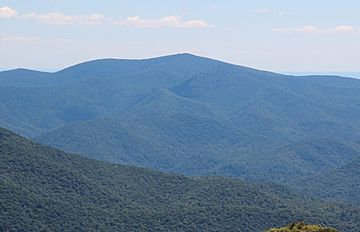
Tray Mountain viewed from Brasstown Bald
|
|
| Highest point | |
| Elevation | 4,430 ft (1,350 m) |
| Geography | |
| Location | Habersham / Towns / White counties, Georgia, U.S. |
| Parent range | Blue Ridge Mountains |
| Topo map | USGS Tray Mountain |
| Climbing | |
| First ascent | unknown |
| Easiest route | Appalachian Trail |
Tray Mountain is a tall peak in Georgia. It stands at about 4,430 ft (1,350 m) high. This makes it the seventh-highest mountain in the state. The mountain is found where White, Towns, and Habersham counties meet. It is a special part of the Chattahoochee National Forest.
About Tray Mountain
Tray Mountain is a well-known spot in the Blue Ridge Mountains. The top of the mountain is located in Towns County. However, parts of the mountain also stretch into White and Habersham counties.
This mountain is inside the Chattahoochee National Forest. It is also part of the Tray Mountain Wilderness. This means the area is protected and kept wild.
Many people call Tray Mountain a "grandstand." This is because it offers amazing views. From its peak, you can see the Nantahala Mountains in North Carolina. You can also see other parts of the Blue Ridge Mountains in Georgia.
A famous hiking path, the Appalachian Trail, crosses right over Tray Mountain. This makes it a popular stop for hikers.
Why is it called Tray Mountain?
The name "Tray" for the mountain likely comes from an older name. People think it was once called "Trail Mountain." This makes sense because many trails cross over the mountain. Over time, "Trail" might have changed into "Tray."
 | DeHart Hubbard |
 | Wilma Rudolph |
 | Jesse Owens |
 | Jackie Joyner-Kersee |
 | Major Taylor |

