Treasure Coast International Airport facts for kids
Quick facts for kids
Treasure Coast International Airport
|
|||||||||||||||||||
|---|---|---|---|---|---|---|---|---|---|---|---|---|---|---|---|---|---|---|---|
| Summary | |||||||||||||||||||
| Airport type | International | ||||||||||||||||||
| Owner | St. Lucie Board of County Commissioners | ||||||||||||||||||
| Location | Fort Pierce, Florida | ||||||||||||||||||
| Elevation AMSL | 23 ft / 7 m | ||||||||||||||||||
| Coordinates | 27°29′42″N 080°22′06″W / 27.49500°N 80.36833°W | ||||||||||||||||||
| Website | Website | ||||||||||||||||||
| Runway | |||||||||||||||||||
|
|||||||||||||||||||
| Statistics (2009) | |||||||||||||||||||
|
|||||||||||||||||||
|
Source: Federal Aviation Administration
|
|||||||||||||||||||
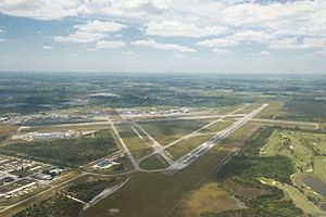
Treasure Coast International Airport (FPR/KFPR/FPR) is a public airport located about three miles (5 km) northwest of downtown Fort Pierce. Fort Pierce is a city in St. Lucie County, Florida, United States. The St. Lucie Board of County Commissioners owns this airport.
Many flight schools in South Florida use this airport often. Three of these schools are even based right at the airport. They use it for training pilots to fly different kinds of planes. The airport also has a special area called a Federal Inspection Station (FIS). Here, United States Customs & Border Protection checks planes and people. This makes it a common stop for private planes flying to and from the Bahama Islands.
A company called DayJet used to offer on-demand jet rides from this airport. This was like an air taxi service. However, they stopped their operations in September 2008.
Contents
The Airport's History
The story of this airport began a long time ago, in 1921. A group called The Commercial Club of Fort Pierce built an airport. It was meant for an airline that never actually started flying. This first airport was located where the local American Legion building stands today on U.S. Route 1.
Nine years later, in 1930, the county bought a large piece of land. This land eventually became the airport we know today. The first official commercial airport in the area opened in 1935. It was located near U.S. Route 1 and Edwards Road.
World War II and Beyond
The current airport was first called Fort Pierce Airport. During World War II, the U.S. Navy used it. It served as an extra airfield for pilots and flight crews. These crews came from other Navy air stations nearby. They practiced landing planes during the day and night. This practice helped them get ready to land on real aircraft carriers.
Planes like scout aircraft, dive bombers, and torpedo attack bombers used the runways. The military even changed the runways to make them better for Navy training. In 1947, the Navy stopped using the airport. The U.S. Government then gave the airport back to the county. They even included the new runways they had built, without charging for them!
After the war, the county didn't have much money to keep the airport running. For the next ten years, the airport was not well-maintained. It became overgrown with plants, and cattle from nearby farms often grazed there.
Modern Improvements
Things started to change for the better in the 1960s and 1970s. Many big improvements were made. They built an airport terminal, modern hangars (where planes are stored), and new lighting for the airfield. They also added tools to help planes navigate and places to get fuel. Curtis King became the first full-time director in 1967. He worked for 31 years and helped a lot with developing the airport.
The airport continued to grow as a place for general aviation. General aviation means all flights that are not military or scheduled airline flights. Even though two of the four runways were closed, one old runway became a business park. Another runway, called 10R/28L, was made longer and better.
In early 2010, a new runway, 10L/28R, was finished. It cost $15.3 million. A new taxiway was also completed. This taxiway connects the training runway (10L/28R) to the main runway (10R/28L). This helps training planes move around without needing to use the main runways as much for takeoffs and landings.
Airport Features and Activity
Treasure Coast International Airport covers a large area of 3,844 acres (1,556 hectares). It has three asphalt paved runways:
- 10R/28L is 6,492 feet (1,979 meters) long and 150 feet (46 meters) wide.
- 10L/28R is 4,000 feet (1,219 meters) long and 75 feet (23 meters) wide.
- 14/32 is 4,755 feet (1,449 meters) long and 100 feet (30 meters) wide.
In the 12 months leading up to January 15, 2009, the airport had 196,000 general aviation aircraft operations. This means about 537 planes took off or landed there each day. There are 186 aircraft that call this airport their home base.
- 68% are single-engine planes (planes with one engine).
- 27% are multi-engine planes (planes with more than one engine).
- 3% are jet planes.
- 3% are helicopters.
About 53% of the flights are local general aviation. This means planes flying around the airport for training or local trips. The other 47% are transient general aviation. These are planes flying in from other places or heading out to other destinations.
 | Stephanie Wilson |
 | Charles Bolden |
 | Ronald McNair |
 | Frederick D. Gregory |


