
Trenton, Maine facts for kids
Quick facts for kids
Trenton, Maine
|
|
|---|---|
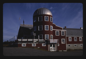
_IMG_2442.JPG)
The Trenton Lighthouse is not a lighthouse but a business building, now containing a restaurant, The Beacon.
|
|

Trenton, Maine
Location in Maine

Trenton, Maine
Location in the United States
|
|
| Country | United States |
| State | Maine |
| County | Hancock |
| Villages | Trenton Bayside West Trenton |
| Area | |
| • Total | 28.39 sq mi (73.53 km2) |
| • Land | 18.17 sq mi (47.06 km2) |
| • Water | 10.22 sq mi (26.47 km2) |
| Elevation | 49 ft (15 m) |
| Population
(2020)
|
|
| • Total | 1,584 |
| • Density | 87/sq mi (33.7/km2) |
| Time zone | UTC-5 (Eastern (EST)) |
| • Summer (DST) | UTC-4 (EDT) |
| ZIP code |
04605
|
| Area code(s) | 207 |
| FIPS code | 23-77415 |
| GNIS feature ID | 0582768 |
Trenton is a small town in Maine, a state in the United States. It is located in Hancock County, very close to the beautiful Acadia National Park. In 2020, about 1,584 people lived there. You can also find the Hancock County-Bar Harbor Airport in Trenton.
Back in 1969, the people of Trenton voted on a big idea. They decided against building a nuclear power plant and a factory that makes aluminum. The vote was 144 against and 77 for.
Contents
About Trenton's Land and Water
Trenton covers a total area of about 28.39 square miles (73.53 square kilometers). Most of this area, about 18.17 square miles (47.06 square kilometers), is land. The rest, about 10.22 square miles (26.47 square kilometers), is water.
How Many People Live in Trenton?
Trenton's population has changed over many years. Here is a look at how the number of people living in the town has grown or shrunk:
| Historical population | |||
|---|---|---|---|
| Census | Pop. | %± | |
| 1790 | 312 | — | |
| 1800 | 294 | −5.8% | |
| 1810 | 501 | 70.4% | |
| 1820 | 639 | 27.5% | |
| 1830 | 794 | 24.3% | |
| 1840 | 1,062 | 33.8% | |
| 1850 | 1,205 | 13.5% | |
| 1860 | 1,400 | 16.2% | |
| 1870 | 678 | −51.6% | |
| 1880 | 639 | −5.8% | |
| 1890 | 528 | −17.4% | |
| 1900 | 459 | −13.1% | |
| 1910 | 354 | −22.9% | |
| 1920 | 314 | −11.3% | |
| 1930 | 338 | 7.6% | |
| 1940 | 403 | 19.2% | |
| 1950 | 358 | −11.2% | |
| 1960 | 375 | 4.7% | |
| 1970 | 392 | 4.5% | |
| 1980 | 718 | 83.2% | |
| 1990 | 1,060 | 47.6% | |
| 2000 | 1,370 | 29.2% | |
| 2010 | 1,481 | 8.1% | |
| 2020 | 1,584 | 7.0% | |
| U.S. Decennial Census | |||
Trenton's Population in 2010
In 2010, there were 1,481 people living in Trenton. These people lived in 663 homes, and 409 of these were families. On average, there were about 81.5 people per square mile.
Most of the people in Trenton were White (95.3%). A smaller number were Native American (1.6%), African American (0.4%), or Asian (0.4%). About 1.5% of the population was Hispanic or Latino.
In Trenton, 23.7% of homes had children under 18. Almost half of the homes (46.8%) were married couples living together. About 38.3% of homes were not families, meaning people lived alone or with roommates.
The average age of people in Trenton was 45.8 years old. About 17.4% of residents were under 18. About 15.1% were 65 years old or older. The town had slightly more males (50.6%) than females (49.4%).
Businesses in Trenton
Trenton has been home to some interesting businesses. For example, Bar Harbor Airlines, a regional airline, used to have its main office here. In 1989, the airline moved its headquarters to Houston, Texas.
See also
 In Spanish: Trenton (Maine) para niños
