Tricouni Peak facts for kids
Quick facts for kids Tricouni Peak |
|
|---|---|
 |
|
| Highest point | |
| Elevation | 2,122 m (6,962 ft) |
| Prominence | 252 m (827 ft) |
| Geography | |
| Location | British Columbia, Canada |
| Parent range | Pacific Ranges |
| Topo map | NTS 92J/03 |
| Climbing | |
| First ascent | 1931 J. Cherry; T. Fyles; H. Wynne |
| Easiest route | rock/ice climb |
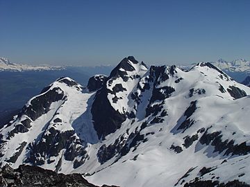
Tricouni Peak is a mountain found in the beautiful British Columbia, Canada. It is part of the Pacific Ranges, which are a large group of mountains within the Coast Mountains. This peak stands tall south of another mountain called Cypress Peak.
About Tricouni Peak
Tricouni Peak is a notable mountain in southwestern British Columbia. It reaches an elevation of 2,122 meters (about 6,962 feet) above sea level. This makes it a significant landmark in the area.
Where is Tricouni Peak?
This mountain is located in a region known as the Squamish-Cheakamus divide. This is an area that separates two important river systems. The mountain is part of the larger Coast Mountains range. These mountains stretch along the coast of British Columbia.
How Tricouni Peak Got Its Name
Tricouni Peak received its name in 1931. A group of climbers, including Tom Fyles, gave it this name. They were the first people to successfully climb the mountain. Tom Fyles explained that the mountain looked like "three cones" from a distance. This is why they chose the name "Tricouni Mountain." The name "Tricouni Peak" was officially accepted on June 22, 1967.
 | Delilah Pierce |
 | Gordon Parks |
 | Augusta Savage |
 | Charles Ethan Porter |

