Trout River (Chateauguay River tributary) facts for kids
Quick facts for kids Trout River |
|
|---|---|

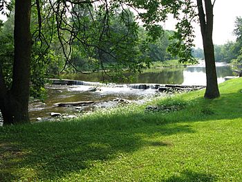
Trout River at the St-Onge Dam
|
|
| Native name | Rivière Trout |
| Country | United States, Canada |
| State - Province | New York State, Quebec |
| Region | Adirondack Park (New York State), Montérégie (Quebec) |
| Region | Franklin County, New York, Le Haut-Saint-Laurent Regional County Municipality |
| Physical characteristics | |
| Main source | Adirondack Park |
| River mouth | Elgin, Godmanchester, Montérégie (Québec, Canada) 45 metres (148 ft) |
| Length | 57.6 kilometres (35.8 mi) |
| Basin features | |
| Progression | Chateauguay River - Saint Lawrence River |
| River system | Saint Lawrence River |
| Basin size | 427.35 square kilometres (165.00 sq mi) |
| Tributaries |
|
The Trout River (also known as Rivière Trout in French) is a river that flows into the Chateauguay River. It starts in the Adirondack Park in New York State, United States. Then, it crosses into Canada, flowing through the towns of Godmanchester and Elgin in Quebec.
This river valley is mostly served by Route 138 in Quebec, which runs along the west side of the river. In New York State, you can find roads like Constable Street and State Highway 30 nearby.
The Trout River usually freezes over from mid-December to the end of March. It's generally safe to walk on the ice from late December to early March. The amount of water in the river changes with the seasons and how much rain or snow falls.
River's Journey
The Trout River begins in the Adirondack Mountains in upstate New York, United States. It gets its water from several smaller streams, including the Little Trout River.
The Trout River is not very wide or deep, so boats cannot easily travel on it. Its drainage basin (the area of land where all the water flows into the river) is about 427.35 square kilometres (165.00 sq mi). This basin flows between the towns of Elgin and Godmanchester.
Much of the land along the river is privately owned by local residents. This means that people who own land next to the river also own the riverbed up to the middle of the river. This gives them rights to fish and use the riverbed in front of their property. However, these private rights must also respect the rights of others, as the river is also seen as a shared resource.
The Trout River has two dams. One is the St-Onge Dam, located in the small village of Trout River in Elgin, close to the Canada-US border. The other is the Hooker Dam, which is found between the village of Kensington in Godmanchester and a road called the second concession in Elgin. The Trout River eventually flows into the Chateauguay River just south of the town of Huntingdon. There's even a rest stop on Route 138 where the two rivers meet.
American Side of the River
From its start in Adirondack Park, the Trout River flows for about 57.6 kilometres (35.8 mi). The first part of its journey, about 34.5 kilometres (21.4 mi), is on the American side.
- It flows about 4.8 kilometres (3.0 mi) north, then northwest, reaching the northern edge of Adirondack Park.
- Next, it travels about 7.2 kilometres (4.5 mi) northwest, making a big curve to the northeast. It crosses Brainardsville Road and Donohue Road, then turns west, crossing Burke City Road, until it reaches Highway 11.
- It continues about 8.6 kilometres (5.3 mi) northwest, close to Constable Street. Here, the river turns north, crosses Town Line Road, and then bends west towards the Constable Street Bridge.
- For about 6.1 kilometres (3.8 mi), it flows northwest, crossing County Highway 22 and making a few loops. It then bends northeast to meet State Highway 30, where the Little Trout River (New York) joins it from the southeast.
- Finally, for about 7.8 kilometres (4.8 mi), it flows north, forming a large "S" shape. It passes west of the Trout River State Forest and generally follows State Highway 30, crossing Stebbin Road. It curves west at the end of this section, reaching the Canada-US border.
Canadian Side of the River
The Canadian part of the Trout River's journey is about 23.1 kilometres (14.4 mi) long.
- It flows about 7.3 kilometres (4.5 mi) north, making a big "S" shape through farmland. It forms a loop to the east and another to the west, ending near a small village where Route 138 and Montée Leblanc meet.
- Then, it flows about 4.2 kilometres (2.6 mi) northeast, mostly in a straight line, with a hook to the north at the end. Here, the Beaver stream joins it from the northeast.
- The last section is about 11.6 kilometres (7.2 mi) long, flowing northeast and winding through two areas. It passes north of the village of Kelvingrove and collects the Pringle stream from the west before reaching its end.
The Trout River flows into the west bank of the Châteauguay River, about 1.6 kilometres (0.99 mi) south of the village of Hemmingford. From there, the water travels down the Châteauguay River for about 60.3 kilometres (37.5 mi) until it reaches the south shore of Lac Saint-Louis, near Châteauguay, southwest of Montreal.
River's Name
In both Franklin County, New York (USA) and in Canada, this river is called "Trout River."
The Commission de toponymie du Québec, which is the official body for naming places in Quebec, formally recognized the name "Trout River" on September 22, 1976.
 | William L. Dawson |
 | W. E. B. Du Bois |
 | Harry Belafonte |

