Troy Peak facts for kids
Quick facts for kids Troy Peak |
|
|---|---|

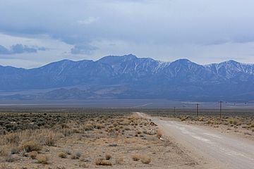
Seen from the White River Valley
|
|
| Highest point | |
| Elevation | 11,302 ft (3,445 m) NAVD 88 |
| Prominence | 4,790 ft (1,460 m) |
| Geography | |
| Location | Nye County, Nevada, U.S. |
| Parent range | Grant Range |
| Topo map | USGS Troy Canyon |
| Climbing | |
| Easiest route | Southeast ridge: steep hike/scramble |
Troy Peak is a tall mountain located in Nevada, United States. It is the highest point in the Grant Range, a group of mountains found in northeastern Nye County. This impressive peak is also one of the highest mountains in all of Nevada!
About Troy Peak
Troy Peak stands at an elevation of 11,302 feet (about 3,445 meters) above sea level. This makes it the thirty-sixth highest mountain in the entire state of Nevada. It's also known for its "prominence," which means it rises very high above the land around it. Troy Peak is the third-most prominent peak in Nye County and the fourteenth-most prominent in Nevada.
Where is Troy Peak?
This mountain is located about 72 miles (116 kilometers) southwest of the city of Ely. It is part of the Grant Range Wilderness, which is a special protected area within the larger Humboldt-Toiyabe National Forest. This forest is a huge natural area that covers parts of Nevada and California.
The Grant Range
The Grant Range is a mountain chain where Troy Peak is the tallest point. Mountain ranges are long lines of mountains that are connected. The Grant Range is known for its beautiful natural scenery and is a great place for outdoor activities.
Humboldt-Toiyabe National Forest
The Humboldt-Toiyabe National Forest is the largest national forest in the lower 48 states. It covers a vast area and includes many different types of landscapes, from deserts to high mountains. These forests are managed to protect wildlife, provide clean water, and offer places for people to enjoy nature, like hiking and camping. The Grant Range Wilderness within it means that this specific area is kept wild and undeveloped.
 | Audre Lorde |
 | John Berry Meachum |
 | Ferdinand Lee Barnett |


