Tumacacori, Arizona facts for kids
Quick facts for kids
Tumacacori-Carmen, Arizona
|
|
|---|---|

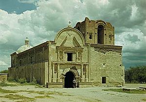
Tumacacori mission, 1947. Photo: George A. Grant
|
|

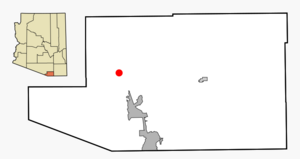
Location in Santa Cruz County and the state of Arizona
|
|
| Country | |
| State | |
| County | Santa Cruz |
| Area | |
| • Total | 1.91 sq mi (4.96 km2) |
| • Land | 1.91 sq mi (4.95 km2) |
| • Water | 0.00 sq mi (0.00 km2) |
| Population
(2020)
|
|
| • Total | 329 |
| • Density | 172.07/sq mi (66.44/km2) |
| Time zone | UTC-7 (MST (no DST)) |
| ZIP code |
85640
|
| Area code(s) | 520 |
| FIPS code | 04-77367 |
Tumacacori is a small community located in Santa Cruz County, Arizona, in the United States. It is right next to another community called Carmen. When these two communities are counted together, they form what is known as the Tumacacori-Carmen census-designated place (CDP). A CDP is a special area defined by the government for counting people, but it's not an officially incorporated town or city. In 2010, about 393 people lived here.
Contents
History of Tumacacori
Tumacacori is famous for being the home of Mission San José de Tumacácori. This mission was a church and settlement built by Franciscan missionaries in the late 1700s.
Early Mission History
The name Tumacacori comes from an even older mission site. This first site was started by a priest named Father Eusebio Kino in 1691. It was located on the east side of the Santa Cruz River. This early mission was built where a native village already existed. The people living there were either O'odham or Sobaipuri. This was the very first mission in southern Arizona. You can still see the remains of this old native settlement today.
The Franciscan Mission and Its Challenges
The later Franciscan mission, which is the one you can visit now, became a ruin. It was never rebuilt after facing many attacks. In the 1800s, there were repeated raids by the Apache people. These attacks made it unsafe for farmers and ranchers, stopping the area from growing. Nearby Tubac was even attacked in 1861. Today, the mission is preserved as Tumacácori National Historical Park.
Geography and Climate
The Tumacacori-Carmen area covers about 5.1 square kilometers (about 1.9 square miles). All of this land is dry land. The community is located in a valley. This valley was formed by the Santa Cruz River flowing through it.
Understanding Tumacacori's Climate
Tumacacori has a semi-arid climate. This means it's usually dry, but it does get some rain. The winters are cool, and the summers are hot.
| Climate data for Tumacácori National Historical Park, Arizona, 1991–2020 normals, extremes 1946–present | |||||||||||||
|---|---|---|---|---|---|---|---|---|---|---|---|---|---|
| Month | Jan | Feb | Mar | Apr | May | Jun | Jul | Aug | Sep | Oct | Nov | Dec | Year |
| Record high °F (°C) | 89 (32) |
92 (33) |
95 (35) |
100 (38) |
109 (43) |
113 (45) |
113 (45) |
108 (42) |
108 (42) |
104 (40) |
93 (34) |
88 (31) |
113 (45) |
| Mean maximum °F (°C) | 77.4 (25.2) |
79.8 (26.6) |
85.5 (29.7) |
91.6 (33.1) |
98.3 (36.8) |
105.0 (40.6) |
104.2 (40.1) |
100.6 (38.1) |
97.6 (36.4) |
93.3 (34.1) |
84.3 (29.1) |
77.0 (25.0) |
106.2 (41.2) |
| Mean daily maximum °F (°C) | 63.3 (17.4) |
65.7 (18.7) |
71.8 (22.1) |
78.2 (25.7) |
86.0 (30.0) |
95.1 (35.1) |
93.4 (34.1) |
91.2 (32.9) |
88.5 (31.4) |
81.1 (27.3) |
71.3 (21.8) |
62.7 (17.1) |
79.0 (26.1) |
| Daily mean °F (°C) | 47.7 (8.7) |
49.7 (9.8) |
54.9 (12.7) |
60.4 (15.8) |
67.6 (19.8) |
77.1 (25.1) |
80.1 (26.7) |
78.5 (25.8) |
74.1 (23.4) |
64.5 (18.1) |
54.7 (12.6) |
47.2 (8.4) |
63.0 (17.2) |
| Mean daily minimum °F (°C) | 32.0 (0.0) |
33.8 (1.0) |
38.0 (3.3) |
42.5 (5.8) |
49.1 (9.5) |
59.0 (15.0) |
66.8 (19.3) |
65.8 (18.8) |
59.8 (15.4) |
47.9 (8.8) |
38.2 (3.4) |
31.8 (−0.1) |
47.1 (8.4) |
| Mean minimum °F (°C) | 20.2 (−6.6) |
22.6 (−5.2) |
26.2 (−3.2) |
31.2 (−0.4) |
38.5 (3.6) |
48.1 (8.9) |
57.4 (14.1) |
59.0 (15.0) |
49.1 (9.5) |
34.8 (1.6) |
23.7 (−4.6) |
19.8 (−6.8) |
16.8 (−8.4) |
| Record low °F (°C) | 4 (−16) |
9 (−13) |
15 (−9) |
20 (−7) |
28 (−2) |
38 (3) |
42 (6) |
47 (8) |
36 (2) |
18 (−8) |
9 (−13) |
5 (−15) |
4 (−16) |
| Average precipitation inches (mm) | 1.15 (29) |
1.07 (27) |
0.81 (21) |
0.31 (7.9) |
0.17 (4.3) |
0.47 (12) |
3.79 (96) |
3.35 (85) |
1.83 (46) |
1.09 (28) |
0.89 (23) |
1.02 (26) |
15.95 (405) |
| Average snowfall inches (cm) | 0.1 (0.25) |
0.0 (0.0) |
0.0 (0.0) |
0.0 (0.0) |
0.0 (0.0) |
0.0 (0.0) |
0.0 (0.0) |
0.0 (0.0) |
0.0 (0.0) |
0.0 (0.0) |
0.0 (0.0) |
0.0 (0.0) |
0.1 (0.25) |
| Average precipitation days (≥ 0.01 inch) | 3.6 | 3.9 | 2.7 | 1.5 | 0.7 | 1.8 | 11.4 | 10.1 | 5.0 | 2.5 | 2.1 | 3.7 | 49.0 |
| Average snowy days (≥ 0.1 inch) | 0.0 | 0.0 | 0.0 | 0.0 | 0.0 | 0.0 | 0.0 | 0.0 | 0.0 | 0.0 | 0.0 | 0.0 | 0.0 |
| Source: NOAA | |||||||||||||
Population and People
| Historical population | |||
|---|---|---|---|
| Census | Pop. | %± | |
| 2020 | 329 | — | |
| U.S. Decennial Census | |||
In 2020, the population of Tumacacori-Carmen was 329 people. Back in 2000, there were 569 people living there. The community is home to a mix of different people. Many residents identify as White or Hispanic or Latino.
Community Life
In 2000, about 26.5% of homes had children under 18 living in them. The average household had about 2.55 people. The community's population was spread out across different age groups. About 23.7% of the people were under 18 years old. The median age, which is the middle age of all the people, was 41 years old.
Arts and Culture
One important cultural spot in Tumacacori is the Tumacacori National Park Museum. This building was once used by the Franciscan missionaries at the Mission San José de Tumacácori. It helps visitors learn about the history of the mission and the people who lived there.


