
Tumaco facts for kids
Quick facts for kids
San Andrés de Tumaco
|
|||
|---|---|---|---|
|
Municipality and city
|
|||
|
|
|||
|
|||
| Motto(s):
Tumaco For Everyone
|
|||

Location of the municipality (red) of Tumaco in the Nariño Department.
|
|||

Tumaco
Location in Colombia
|
|||
| Country | Colombia | ||
| Department | Nariño Department | ||
| Founded | 1640 | ||
| Area | |||
| • Municipality and city | 3,612 km2 (1,395 sq mi) | ||
| • Urban | 11.25 km2 (4.34 sq mi) | ||
| Elevation | 2 m (7 ft) | ||
| Population
(2020 est.)
|
|||
| • Municipality and city | 257,052 | ||
| • Density | 71.166/km2 (184.319/sq mi) | ||
| • Urban | 86,614 | ||
| • Urban density | 7,699/km2 (19,940/sq mi) | ||
| Demonym(s) | Tumaquian | ||
| Time zone | UTC−5 | ||
| Area code(s) | 57 + 2 | ||


.svg)
Tumaco is a port city and a local government area (municipality) in the Nariño Department, Colombia. It is located on the Pacific Ocean coast. Tumaco is in the southwest corner of Colombia, close to the border with Ecuador. The city has a hot, tropical climate. Most people living in Tumaco are Afro-Colombians, and there are also some indigenous people.
You can reach Tumaco by plane from Pasto, which is the capital city of Nariño Department. Flights also come from Cali and Bogotá. You can also travel to Tumaco by road from Pasto and San Lorenzo in Ecuador. Tumaco is famous for being the home of many great Colombian soccer players, like Willington Ortiz.
In 2009, Colombian film director Samuel Córdoba made a documentary about Tumaco. The film is called "Tumaco Pacífico." It shows the part of the city with houses built on stilts, where many Afro-Colombians live. Córdoba was inspired by a photo of these stilt houses he saw in a book about Tumaco. The film won first prize at a film festival in France. It was also shown at an international film festival in Chile.
Other interesting places to visit include nature tourism spots and beaches near the Mira River. Here, the river meets the sea. You can also find the Playas de Milagros (Beaches of Miracles), and the Bocananueva y Teran beaches. Visitors can see many different plants and animals in these areas.
Contents
What is the Weather Like in Tumaco?
Like other places on the Colombian Pacific coast, Tumaco has a hot, rainy, and humid tropical rainforest climate. This type of climate is known as Af in the Köppen system. Tumaco gets about 2,600 millimeters (102 inches) of rain each year. This is less than some areas further north in Colombia. For example, Buenaventura gets about 6,900 mm (272 inches) and Quibdó gets about 8,130 mm (320 inches). The wettest months are from January to June. There is less rain in August, which is different from northern Colombia.
| Climate data for Tumaco (Cccp Dl Pacifico), elevation 1 m (3.3 ft), (1981–2010) | |||||||||||||
|---|---|---|---|---|---|---|---|---|---|---|---|---|---|
| Month | Jan | Feb | Mar | Apr | May | Jun | Jul | Aug | Sep | Oct | Nov | Dec | Year |
| Mean daily maximum °C (°F) | 29.0 (84.2) |
29.3 (84.7) |
29.6 (85.3) |
29.7 (85.5) |
29.4 (84.9) |
29.2 (84.6) |
29.1 (84.4) |
29.1 (84.4) |
28.9 (84.0) |
29.0 (84.2) |
28.8 (83.8) |
28.8 (83.8) |
29.1 (84.4) |
| Daily mean °C (°F) | 25.8 (78.4) |
26.1 (79.0) |
26.3 (79.3) |
26.5 (79.7) |
26.4 (79.5) |
26.1 (79.0) |
25.9 (78.6) |
25.9 (78.6) |
25.8 (78.4) |
25.8 (78.4) |
25.6 (78.1) |
25.7 (78.3) |
26 (79) |
| Mean daily minimum °C (°F) | 23.3 (73.9) |
23.5 (74.3) |
23.8 (74.8) |
23.8 (74.8) |
23.8 (74.8) |
23.6 (74.5) |
23.5 (74.3) |
23.5 (74.3) |
23.6 (74.5) |
23.6 (74.5) |
23.5 (74.3) |
23.4 (74.1) |
23.6 (74.5) |
| Average precipitation mm (inches) | 341.8 (13.46) |
276.8 (10.90) |
286.9 (11.30) |
330.8 (13.02) |
360.1 (14.18) |
217.8 (8.57) |
166.4 (6.55) |
97.1 (3.82) |
125.5 (4.94) |
113.9 (4.48) |
136.2 (5.36) |
205.1 (8.07) |
2,610.6 (102.78) |
| Average precipitation days | 21 | 19 | 19 | 21 | 24 | 22 | 19 | 16 | 17 | 15 | 14 | 17 | 220 |
| Average relative humidity (%) | 88 | 88 | 86 | 87 | 88 | 88 | 87 | 86 | 86 | 86 | 87 | 88 | 87 |
| Mean monthly sunshine hours | 114.7 | 127.0 | 158.1 | 153.0 | 124.0 | 111.0 | 130.2 | 142.6 | 105.0 | 108.5 | 99.0 | 105.4 | 1,478.5 |
| Mean daily sunshine hours | 3.7 | 4.5 | 5.1 | 5.1 | 4.0 | 3.7 | 4.2 | 4.6 | 3.5 | 3.5 | 3.3 | 3.4 | 4.1 |
| Source: Instituto de Hidrologia Meteorologia y Estudios Ambientales | |||||||||||||
| Climate data for Tumaco (Mira El Gja), elevation 16 m (52 ft), (1981–2010) | |||||||||||||
|---|---|---|---|---|---|---|---|---|---|---|---|---|---|
| Month | Jan | Feb | Mar | Apr | May | Jun | Jul | Aug | Sep | Oct | Nov | Dec | Year |
| Mean daily maximum °C (°F) | 30.0 (86.0) |
30.6 (87.1) |
31.1 (88.0) |
31.0 (87.8) |
30.3 (86.5) |
29.8 (85.6) |
29.7 (85.5) |
29.5 (85.1) |
29.3 (84.7) |
29.4 (84.9) |
29.5 (85.1) |
29.4 (84.9) |
30.0 (86.0) |
| Daily mean °C (°F) | 25.7 (78.3) |
26.0 (78.8) |
26.2 (79.2) |
26.2 (79.2) |
26.0 (78.8) |
25.4 (77.7) |
25.4 (77.7) |
25.3 (77.5) |
25.2 (77.4) |
25.3 (77.5) |
25.3 (77.5) |
25.4 (77.7) |
25.6 (78.1) |
| Mean daily minimum °C (°F) | 22.4 (72.3) |
22.8 (73.0) |
22.7 (72.9) |
23.1 (73.6) |
23.0 (73.4) |
22.9 (73.2) |
22.5 (72.5) |
22.5 (72.5) |
22.6 (72.7) |
22.6 (72.7) |
22.5 (72.5) |
22.6 (72.7) |
22.7 (72.9) |
| Average precipitation mm (inches) | 298.4 (11.75) |
274.6 (10.81) |
260.2 (10.24) |
359.4 (14.15) |
418.8 (16.49) |
288.5 (11.36) |
232.2 (9.14) |
143.5 (5.65) |
174.1 (6.85) |
153.2 (6.03) |
137.5 (5.41) |
206.1 (8.11) |
2,946.6 (116.01) |
| Average precipitation days | 23 | 20 | 20 | 23 | 26 | 23 | 21 | 17 | 20 | 20 | 17 | 20 | 246 |
| Average relative humidity (%) | 88 | 88 | 87 | 88 | 89 | 89 | 89 | 88 | 88 | 88 | 89 | 89 | 88 |
| Mean monthly sunshine hours | 80.6 | 87.5 | 105.4 | 102.0 | 83.7 | 60.0 | 83.7 | 77.5 | 57.0 | 65.1 | 57.0 | 65.1 | 924.6 |
| Mean daily sunshine hours | 2.6 | 3.1 | 3.4 | 3.4 | 2.7 | 2.0 | 2.7 | 2.5 | 1.9 | 2.1 | 1.9 | 2.1 | 2.5 |
| Source: Instituto de Hidrologia Meteorologia y Estudios Ambientales | |||||||||||||
How Does Tumaco Make Money?
Tumaco's location on the coast means it has many ways to make money from the sea.
- Fishing: One of the main ways people earn a living is through artisanal fishing. This means people catch fish using traditional methods.
- Shrimp Farming: Raising shrimp in special farms is also a big part of the economy.
In recent years, farming has also grown.
- Main Crops: Crops like African palm, dry rice, and cocoa are now grown using machines.
- Family Farms: Smaller farms, called pancoger plots, grow food mainly for the families who live there. This is a key source of food for the local people.
What Plants Are Grown in Tumaco?
- Cocoa: Many farmers grow cocoa.
- Tagua: Another product is tagua, also called ivory nut or vegetable ivory. This is a seed from the Phytelephas macrocarpa palm tree. Even though its production has slowed down, Tumaco still produces a lot of it.
- African Palm: The African palm (Elaeis guineensis) is also grown for its crude palm oil. About 35,000 hectares (135 square miles) are planted with African palm. There are 7 oil factories that create many jobs for the area.
How Does Tourism Help Tumaco?
Tourism has become very important for Tumaco's economy.
- Popular Beaches: The beaches of El Morro, Bocagrande, and El Bajito attract many visitors from Colombia and other countries every day.
- Oil Port: Tumaco is also Colombia's main oil port on the Pacific Ocean. It is the second largest oil port in the country, after Coveñas. In recent years, the oil pipeline and the port have been used to move and export oil from Ecuador. This shows how important the port is for trade.
How Do People Travel in Tumaco?
- Airport: La Florida Airport serves Tumaco. You can fly there from Cali.
- Port: Tumaco has Colombia's second most important Pacific port. The most important is Buenaventura. Because there are not many roads in the area, the port is the main way to reach many villages along the coast.
- Highway: A paved highway, about 300 kilometers (186 miles) long, connects Tumaco with Pasto, the capital of the department.
Images for kids
-
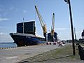
Potosi Merchant vessel unloading fertilizers at the Tumaco port.
-
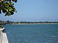
Bajito beach at Tumaco.
-
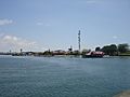
Panoramic view of the Viciosa island at Tumaco.


See Also
 In Spanish: Tumaco para niños
