
Tumbi Umbi, New South Wales facts for kids
Quick facts for kids Tumbi UmbiCentral Coast, New South Wales |
|||||||||||||||
|---|---|---|---|---|---|---|---|---|---|---|---|---|---|---|---|
.jpg)
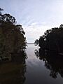
Tumbi Umbi Creek
|
|||||||||||||||

Tumbi Umbi
Location in New South Wales
|
|||||||||||||||
| Population | 5,369 (2021 census) | ||||||||||||||
| Postcode(s) | 2261 | ||||||||||||||
| Elevation | 7 m (23 ft) | ||||||||||||||
| Location |
|
||||||||||||||
| LGA(s) | Central Coast Council | ||||||||||||||
| Parish | Tuggerah | ||||||||||||||
| State electorate(s) |
|
||||||||||||||
| Federal Division(s) | Dobell | ||||||||||||||
|
|||||||||||||||
Tumbi Umbi is a suburb on the Central Coast of New South Wales, Australia. It is located northwest of Bateau Bay along Wyong Road. Tumbi Umbi is a mix of country-like areas and more developed parts. It is managed by the Central Coast Council, which is a type of local government area.
Contents
Discovering Tumbi Umbi's Past
Tumbi Umbi has a special name with a deep meaning.
What Does the Name Mean?
The name "Tumbi Umbi" comes from an Aboriginal language. It means "place of tall trees." This name tells us about the natural environment that was once very common here.
Important Dates in Tumbi Umbi
- 1996: Tumbi Umbi Secondary College opened its doors. This school has been an important part of the community for many years.
Exploring Tumbi Umbi's Geography
Tumbi Umbi is a unique area with different types of landscapes. It sits near Tuggerah Lake and has a creek that flows into it.
Water and Land Features
In the past, Aboriginal people called this area "A place of much water." This was because it had many swampy areas. Over time, much of this land has been drained. Now, you can find houses, businesses, and community places built there.
Different Parts of Tumbi Umbi
Tumbi Umbi has two main types of areas:
- Urban Areas: The more developed parts are found along Wyong Road. They are close to other suburbs like Berkeley Vale, Killarney Vale, and Bateau Bay. Here you will find more homes and shops.
- Rural Areas: The more country-like parts are around Tumbi Road and Palm Valley Road. These areas are next to Glenning Valley, Wamberal, and Forresters Beach. These parts have more open spaces and natural beauty.
Close to the Coast
Even though Tumbi Umbi has rural and urban areas, it is not far from the beautiful coastline. This means residents can easily visit the beach.
Images for kids
-
Tumbi Umbi Creek
