Wamberal, New South Wales facts for kids
Quick facts for kids WamberalCentral Coast, New South Wales |
|||||||||||||||
|---|---|---|---|---|---|---|---|---|---|---|---|---|---|---|---|

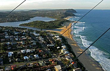
Aerial view of Wamberal Beach
|
|||||||||||||||
| Population | 6,298 (2011 census) | ||||||||||||||
| • Density | 969/km2 (2,510/sq mi) | ||||||||||||||
| Postcode(s) | 2260 | ||||||||||||||
| Elevation | 11 m (36 ft) | ||||||||||||||
| Area | 6.5 km2 (2.5 sq mi) | ||||||||||||||
| Location |
|
||||||||||||||
| LGA(s) | Central Coast Council | ||||||||||||||
| Parish | Kincumber | ||||||||||||||
| State electorate(s) | Terrigal | ||||||||||||||
| Federal Division(s) | Dobell | ||||||||||||||
|
|||||||||||||||
Wamberal is a beautiful coastal area located on the Central Coast of New South Wales, Australia. It sits just north of another popular spot called Terrigal. Wamberal is part of the Central Coast Council local government area.
This suburb is right next to the Wamberal Lagoon. The name "Wamberal" comes from an Aboriginal word. It means 'where the sea breaks', which perfectly describes its beachside location.
Contents
Exploring Wamberal's Location and Features
Wamberal is very close to Terrigal. These two areas are separated by the Terrigal Lagoon Estuary. An estuary is where a river meets the sea.
Different Parts of Wamberal
Wamberal has two main sections. One part is a coastal strip with Wamberal Beach and the Lagoon estuary. This area has many homes and buildings. The other part is more rural, a bit west of the beach. This section has larger properties and hills covered in bushland. These bushland areas are protected to keep the local plants and animals safe.
Getting Around Wamberal
The main road through Wamberal is the Central Coast Highway. This road runs from north to south. It used to be called The Entrance Road. Since 2008, the highway has been improved. It now has four lanes, making travel easier. Ocean View Drive also connects Wamberal to Terrigal from the southeast.
Fun Things to Do in Wamberal
Wamberal has many cool places to visit. Along the beachfront and Ocean View Drive, you'll find cafes, restaurants, and unique shops. The Wamberal Surf Life Saving Club was updated in 2009. It now has a cafe and restaurant, along with new rooms for events and facilities for surf life-saving.
There's also a Country Club called "Breakers". This club honors the efforts of ANZAC soldiers. It has a golf course, a bowling green, and tennis courts. You can also find a restaurant and bars there.
Wamberal Beach Activities
Wamberal Beach is a long sandy stretch, about 3.8 kilometers (2.4 miles) long.
Swimming Safely
The beach often has strong currents called rips, especially north of the surf club. It's very important to always swim between the red and yellow flags. These flags show the safest area to swim, watched by lifeguards. The lagoon also offers a calmer place to swim. It usually has small rips, but if the waves are big, the rips can get stronger. Always be careful and stay within the flagged areas if possible.
Surfing the Waves
Wamberal Beach is great for surfing. It gets good waves and has nice beach breaks. There are also waves over the northern reefs, which surfers enjoy.
Education in Wamberal
Wamberal has a government primary school in its rural area. This school teaches children from kindergarten up to grade six.
Protecting the Coastline
In 2020, big storms caused problems with erosion along the coast. Erosion is when the land wears away, often by water. Finding solutions to protect the coastline from erosion is an ongoing effort.
Who Lives in Wamberal?
In 2011, about 6,298 people lived in Wamberal. Slightly more than half of the residents were female (51.2%), and 48.8% were male. About 1.3% of the population were Aboriginal and Torres Strait Islander people.
The average age in Wamberal was 38 years old. This is just a little older than the national average of 37. Children aged 0 to 14 made up 21.4% of the population. People aged 65 and older made up 13.9%.
Most adults in Wamberal were married (54.3%). About 11.1% were divorced or separated.
How Wamberal's Population Has Grown
Between 2001 and 2006, Wamberal's population grew by 5.08%. Then, from 2006 to 2011, it grew even faster, by 10.24%. This shows that more people are choosing to live in Wamberal.
The average weekly income for people living in Wamberal was about 25% higher than the national average. This means people in Wamberal generally earned more.
Backgrounds and Languages
In 2011, over 83% of Wamberal residents said their family background was Australian or Anglo-Saxon (meaning from England or Scotland). More than 60% of people in Wamberal said they were Christian. This is higher than the national average for Australia.
Most homes in Wamberal speak only English (92.6%). Only a small number (6.3%) speak two or more languages. This is different from the national average, where more homes speak multiple languages.
Wamberal's Property Market
The value of homes in Wamberal has gone up a lot recently. This is because the streets are pleasant and family-friendly. There's also less land available for new buildings. Wamberal is close to shops, public transport, and schools, but it still feels peaceful.
In 2008, a 1940s house on a large beachfront plot was offered for sale. It didn't sell at auction for A$7.2 million. However, that property has since been rebuilt. It is now thought to be worth more than A$10 million, making it one of the most valuable homes on the Central Coast.
This trend of rebuilding and improving properties is making homes in Wamberal more expensive. It's also attracting wealthier buyers to the area. Improvements to local parks and community spaces have also helped. These improvements were partly funded by a government plan to boost the economy. In September 2010, the average house price in Wamberal was A$1.1 million.
 | Claudette Colvin |
 | Myrlie Evers-Williams |
 | Alberta Odell Jones |


