Tuskegee (Cherokee town) facts for kids
Tuskegee (also known as Toskegee or Taskigi) was an important Overhill Cherokee town. It was located along the lower Little Tennessee River in what is now Monroe County, Tennessee, in the United States. The town grew in the late 1750s right next to Fort Loudoun, a British fort. People lived there until the late 1770s. The town was later evacuated and likely burned during the Cherokee–American wars.
Tuskegee is famous as the birthplace of Sequoyah (Cherokee, around 1770-1843). He was a very clever person who created the Cherokee syllabary. This was an amazing writing system for his language. He is one of the few people in history from a society without writing who created a writing system all by himself.
Archaeologists studied the Tuskegee town site in the 1970s. They explored and dug up the area before the valley was flooded. This happened after the Tellico Dam was finished in 1979.
History of Tuskegee
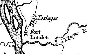
Early explorers made many maps and wrote about the Cherokee lands. But Tuskegee isn't mentioned before 1757. However, a map by William G. De Brahm, who designed Fort Loudoun, shows a place called "Taskigee old Town." This was near where the fort was planned. "Old town" often meant an area that had been cleared or lived in before. We know people lived in this area for thousands of years.
Historians believe the Cherokee town of Tuskegee (also spelled Toskegee) grew after the British built Fort Loudoun. This fort was built by the colony of South Carolina between 1756 and 1757. An early map of the area from 1756 or 1757, drawn by John Stuart, an officer at the fort, does not show Tuskegee.
Also, early letters from Fort Loudoun didn't mention Tuskegee. They usually referred to Tomotley, another Cherokee town further up the river. Tuskegee is first mentioned in a letter from the fort dated January 11, 1757. After that, the town is often mentioned as being in the same spot as Fort Loudoun.
After the Cherokee took over Fort Loudoun, they signed a peace treaty with South Carolina. Then, Virginia sent a peace group, led by Henry Timberlake, to visit the Cherokee lands. This happened in late 1761 and early 1762. Timberlake's map, called "Draught of the Cherokee Country," shows a lot of detail about several Overhill towns, including Tuskegee.
On the map, Tuskegee (spelled "Toskegee") has seventeen buildings. These were probably houses. They were spread out just south of Fort Loudoun. Three of them stood in a line right next to the fort. Tuskegee was one of three towns on Timberlake's map that didn't have a shared meeting house. This suggests it was a smaller settlement. Timberlake noted that Attakullakulla was the leader of both Tuskegee and Mialoquo. He also said that Tuskegee had 55 fighters.
In 1776, the Cherokee attacked the Watauga settlements. In response, Colonel William Christian led an army to the Little Tennessee Valley in October of that year. He found the Cherokee towns empty. Christian burned five of them, including Tuskegee. This town was targeted because the Cherokee had killed a settler boy they captured during the Watauga attack.
Tuskegee was probably not rebuilt or lived in again after this attack. People who traveled to the area later, even those visiting the ruins of Fort Loudoun in the 1790s, did not mention the town.
The famous Cherokee scholar Sequoyah (around 1770-1843) was born at Tuskegee. He created the amazing Cherokee syllabary. He lived in this area until the early 1800s. His mother was a Cherokee woman named Wurtah, and his father was a fur trader named Nathaniel Gist. Sequoyah grew up with his mother's people and spoke only Cherokee for many years. He is one of the few people from a society without writing who created a working writing system by himself. His syllabary inspired 21 other writing systems, used in 65 languages around the world.
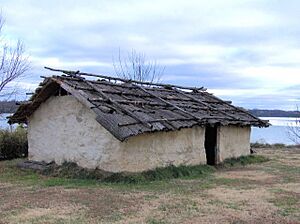
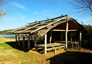
In the late 1900s, the Tennessee Valley Authority (TVA) planned to build the Tellico Dam on the Little Tennessee River. This dam would create a lake that would flood many Cherokee and other ancient sites along the river. The historic Tuskegee site was one of those flooded after the Tellico Dam was finished in 1979. The nearby Fort Loudoun site was raised so it wouldn't be flooded, and the fort was rebuilt. Two Cherokee houses, a "summer" house and a "winter" house, have been rebuilt just south of the fort to show what Tuskegee might have looked like. The Sequoyah Birthplace Museum, which honors the Cherokee scholar, is located along Highway 360, across from Fort Loudoun State Park.
Archaeological Discoveries
The Tennessee Division of Archaeology dug up the Tuskegee site (known as 40MR4, 40MR24, and 40MR64) in the summer of 1976. They did this before the Tellico Dam was completed. The TVA used soil from around the Tuskegee site to raise Fort Loudoun. This allowed archaeologists to examine a large area, about 2.5 acres. These digs found proof of twelve buildings from different times. Some were from the Southern Appalachia Mississippian period. They also found artifacts from as far back as the Archaic period, around 7500 BC. The Tuskegee site is very close to Icehouse Bottom, another important Archaic period site.
Researchers found that three of the twelve buildings were Cherokee. These seemed to match the three houses just south of Fort Loudoun shown on Timberlake's map. Two of these buildings were rectangular. One measured 42.6 feet (13.0 m) by 14.7 feet (4.5 m), and the other was 43.9 ft (13.4 m) by 21.3 ft (6.5 m). These were likely Cherokee "summer" houses, which had open walls for warmer months. The third building was rectangular with rounded corners. It measured 25.9 ft (7.9 m) by 20.3 ft (6.2 m).
Archaeologists also found several trash pits. These pits contained many Cherokee artifacts. These included thousands of pottery pieces (mostly a type called "Overhill Plain"), nails, musket balls, tools, and jewelry.


