Icehouse Bottom facts for kids
Quick facts for kids |
|
|
Icehouse Bottom Site
|
|

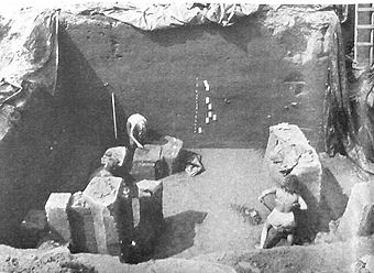
Excavation work at the Icehouse Bottom site
|
|
| Location | Monroe County, Tennessee |
|---|---|
| Nearest city | Vonore |
| Built | circa 7500 BC |
| NRHP reference No. | 78002615 |
| Added to NRHP | 1978 |
Icehouse Bottom is a very old Native American site in Monroe County, Tennessee. It is located along the Little Tennessee River in the southeastern United States. People lived here as early as 7500 BC. This makes it one of the oldest known places where people lived in what is now Tennessee.
Scientists found many artifacts from the Woodland period (1000 BC - 1000 AD) at the site. These items show that the people living at Icehouse Bottom traded with other groups. Their trade network reached as far as Georgia, North Carolina, and Ohio. Later, the Cherokee people lived in this area. They were the Native Americans that European settlers met in the 1700s and 1800s.
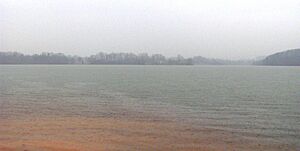
Since 1979, the Icehouse Bottom site has been covered by Tellico Lake. This lake was made when the Tellico Dam was built on the Little Tennessee River. Before the dam was built, archaeologists dug up the site in the early 1970s. They wanted to learn as much as possible before the area was flooded. The Tennessee Valley Authority (TVA) built and manages Tellico Lake. The land around the site is now part of a wildlife area.
Contents
Where Is Icehouse Bottom Located?
The Little Tennessee River flows into Monroe County from the east. It cuts through a gap between the Great Smoky Mountains and the Unicoi Mountains. The river then flows west for about 40 miles (64 km). It eventually joins the Tennessee River near Lenoir City. Tellico Lake was created in 1979. It covers the lower 33 miles (53 km) of the Little Tennessee River.
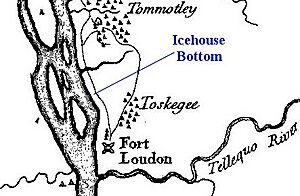
Icehouse Bottom was an ancient human settlement. It was located on the south bank of the Little Tennessee River. Before the dam was built, the site was about 21 miles (34 km) upstream from where the Little Tennessee River meets the Tennessee River. It was also almost 2 miles (3.2 km) upstream from where the Tellico River joins the Little Tennessee. The site was just below a steep hill called Rockcrusher Bluff.
Today, the top of Rockcrusher Bluff is part of the McGhee-Carson Unit. This is a wildlife management area around Tellico Lake. When the lake was filled, the bluff became a peninsula. You can find the entrance to McGhee-Carson along Tennessee State Route 360.
A Look Back in Time: Icehouse Bottom's History
We don't have much written history about Icehouse Bottom itself. However, many important historical places were built nearby. Fort Loudoun, a frontier fort from 1756, was about one mile north. The Tellico Blockhouse, a trading post from 1794, was a little over a mile northeast.
The Overhill Cherokee villages of Tomotley and Toqua were across the river from Rockcrusher Bluff. The Overhill village of Tuskegee was also very close. This village is famous as the birthplace of Sequoyah, a Cherokee scholar.
In 1819, the Cherokee sold their land south of the Little Tennessee River to the United States. This land included all of what is now Monroe County. Soon after, a settler named John McGhee bought thousands of acres along the river. This land included the Icehouse Bottom site. He started farms, called plantations, in the area.
By the early 1900s, the Icehouse Bottom site was part of a tobacco farm. This farm belonged to John Carson's family. The Carson family owned the land when the Tennessee Valley Authority started buying property. They were preparing to create the Tellico Reservoir.
No one is completely sure how Icehouse Bottom got its name. But historian Carson Brewer wrote about a McGhee family story. It mentioned an "ice-house" on their land in the 1800s. People would dig a large hole in winter. Then, they would cut ice from the river or a frozen stream. They put the ice in the hole and covered it with sand. This helped keep the ice frozen all through the summer.
Digging Up the Past: Archaeology at Icehouse Bottom
In 1967, the Tennessee Valley Authority (TVA) began building the Tellico Dam. They bought about 22,000 acres (89 km²) along the river's edge. That same year, the University of Tennessee's anthropology department started a survey. They worked with the National Park Service. Their goal was to find archaeological sites in the valley. They wanted to choose sites to dig before the area was flooded.
At first, they thought they only had two years before the dam would be finished. But legal issues about the environment delayed the dam's completion until 1979. This delay was actually very helpful for archaeologists. It gave them much more time to dig at the sites in the Little Tennessee Valley. This was important because they soon realized how incredibly old these sites were.
Archaeological digs happened at Icehouse Bottom in 1969, 1970, 1971, and 1977. The site was located in the river's flood plain. This meant that every heavy rain added a new layer of earth. This made it easy for archaeologists to study the different layers of history.
Who Lived Here During the Archaic Period?
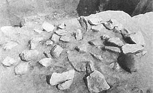
The excavations from 1969-1971 found the burned remains of many clay hearths. These ancient fireplaces were located along the river at Icehouse Bottom. Scientists used Radiocarbon dating to find out how old they were. The oldest hearths date back to around 7500 BC. This was during the Early Archaic period (8000-6000 BC).
This makes Icehouse Bottom one of the oldest known places where people lived semi-permanently in Tennessee. Some hearths even showed marks from netting or baskets. These marks were made when the clay was still wet. Other artifacts found from the Archaic period include unique spear points. Also, netsinkers from the Late Archaic period (3000-1000 BC) were found. Netsinkers are weights used to sink fishing nets.
During the Archaic period, Icehouse Bottom was probably a "base camp." Native Americans likely used it seasonally or for longer periods. The camp had dozens of small homes built along the river. Rockcrusher Bluff nearby had many chert rocks. Chert was important for making tools and weapons. The early people at Icehouse Bottom ate mostly white-tailed deer, black bear, acorns, and hickory nuts. They also hunted smaller animals like squirrels and rabbits.
Who Lived Here During the Woodland Period?
The items found from the Woodland period (1000 BC-1000 AD) at Icehouse Bottom are very interesting. They include maize (corn) that dates back to as early as 100 AD. Maize was a very important crop for Native Americans. Growing and storing corn helped populations grow. It also allowed for more skilled craftspeople to develop.
The Woodland period items also include pottery pieces that came from other places. This shows that the people at Icehouse Bottom were part of a large trading network. Pottery fragments show they traded with other Middle Woodland sites. This included the Hopewell people in Ohio. Human burials and cremations from the Woodland period have also been found nearby.
Icehouse Bottom might have been a manufacturing center during the Middle Woodland period. Pottery pieces confirm a trade network that reached far away. It included the Hopewell centers, and areas in North Carolina like Sylva and Garden Creek. It also reached the McMahan Indian Mounds in Sevierville, and sites in Georgia. Some pottery pieces found at the Hopewell site in Ohio were likely made at Icehouse Bottom.
The site may have also been a place where mica was distributed. Mica is a shiny mineral. After the Middle Woodland period, the site seemed to be used less often. However, a few pieces from the early Mississippian period have been found.
 | John T. Biggers |
 | Thomas Blackshear |
 | Mark Bradford |
 | Beverly Buchanan |


