Twomile Creek (Kanawha River tributary) facts for kids
Quick facts for kids Twomile Creek |
|
|---|---|

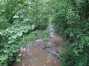
Twomile Creek in Charleston
|
|

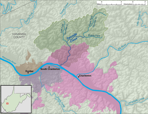
A map of Twomile Creek and its watershed
|
|
| Country | United States |
| State | West Virginia |
| County | Kanawha |
| Physical characteristics | |
| Main source | Right Fork Twomile Creek north-northwest of Elk Hills 973 ft (297 m) 38°26′44″N 81°35′23″W / 38.4456513°N 81.5898468°W |
| 2nd source | Edens Fork northwest of Elk Hills 862 ft (263 m) 38°24′57″N 81°35′42″W / 38.4159296°N 81.595124°W |
| River mouth | Kanawha River Charleston 568 ft (173 m) 38°22′14″N 81°40′34″W / 38.3706516°N 81.6762361°W |
| Length | 4.7 mi (7.6 km) |
| Basin features | |
| Basin size | 24.4 sq mi (63 km2) |
| Tributaries |
|
| Hydrologic Unit Code | 050500080301 (USGS) |
Twomile Creek is a small river, also called a tributary, in West Virginia, United States. It flows into the Kanawha River. The creek is about 4.7 miles (7.6 km) long.
Twomile Creek is part of a larger watershed. This means all the rain and snow that falls in a certain area flows into this creek. Then it goes into the Kanawha River, then the Ohio River, and finally the Mississippi River. The area it drains is about 24.4 square miles (63 km2). This area is in the city of Charleston and nearby.
Contents
Where Twomile Creek Starts
Twomile Creek forms when two smaller streams join together. These streams are called the Right Fork Twomile Creek and Edens Fork. This meeting point is near a place called Guthrie.
The Right Fork
The Right Fork Twomile Creek is about 4.6 miles (7.4 km) long. It begins north of Elk Hills. From there, it flows towards the southwest.
Edens Fork
Edens Fork is shorter, about 2.4 miles (3.9 km) long. It starts northwest of Elk Hills. This fork flows towards the west.
How Twomile Creek Flows
After the Right Fork and Edens Fork meet, Twomile Creek flows west and then south. It passes through the community of Guthrie. Finally, it reaches the city of Charleston. There, it empties into the Kanawha River.
Other Streams Joining In
Another stream, called the Left Fork Twomile Creek, also joins the main creek. This happens near Guthrie. The Left Fork is about 4 miles (6.4 km) long. It starts north of Guthrie and flows south. Roads run alongside Twomile Creek for most of its path.
 | Anna J. Cooper |
 | Mary McLeod Bethune |
 | Lillie Mae Bradford |

