Uiramutã facts for kids
Quick facts for kids
Uiramutã
|
|||
|---|---|---|---|
|
Municipality
|
|||
| Município de Uiramutã | |||

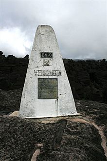
Marker on the Brazil-Venezuela-Guyana border, Monte Roraima
|
|||
|
|||
| Motto(s):
O Brasil começa aqui
(Brazil starts here) |
|||

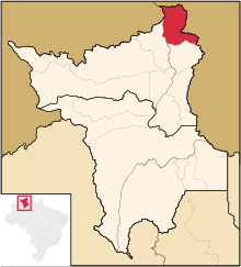
Location of Uiramutã in the State of Roraima
|
|||
| Country | |||
| Region | North | ||
| State | |||
| Founded | October 17, 1995 | ||
| Area | |||
| • Total | 8,066 km2 (3,114 sq mi) | ||
| Elevation | 804 m (2,638 ft) | ||
| Population
(2020)
|
|||
| • Total | 10,789 | ||
| • Density | 0.87/km2 (2.3/sq mi) | ||
| Time zone | UTC−4 (AMT) | ||
| HDI (2000) | 0.542 – medium | ||
| Website | uiramuta.rr.gov.br | ||
Uiramutã is a special kind of city area called a municipality in the northeast part of the state of Roraima in Brazil. In 2020, about 10,789 people lived there. The area of Uiramutã is about 8,066 square kilometers.
This municipality is the northernmost one in Brazil. This means it's the closest to the North Pole compared to any other municipality in the country. The very northernmost point of Brazil, called Monte Caburaí, is found here. West of this mountain, you can also find Monte Roraima. This is the tallest mountain in Roraima and also in Guyana. It's located where Brazil, Guyana, and Venezuela meet, a place called a triple frontier.
Even though Monte Caburaí is the northernmost point, Uiramutã holds the record for having the northernmost urban center (the main town area) of any municipality in Brazil. Other important points in Brazil are:
- To the South: Chuí in the state of Rio Grande do Sul.
- To the West: Mâncio Lima in Acre.
- To the East: João Pessoa in Paraíba.
Life in Uiramutã
The entire municipality of Uiramutã is located inside a special area called the Raposa Serra do Sol Indian Reservation. This means that many of the usual ways people make money, like large-scale farming or mining, are limited here.
Because of these limits, Uiramutã depends a lot on money from the government. About 80% of its income comes from public funds. This includes money for social support and programs like the Bolsa Família, which helps families with their daily needs.
History of Uiramutã
The town of Uiramutã was started in 1911 by a gold miner named Severino Pereira da Silva. He created the village for both the local Indigenous people and other settlers.
Uiramutã became its own independent municipality on October 17, 1995. You can get to Uiramutã by using the RR-171 road.
A long time ago, the United Kingdom claimed this area as part of British Guiana. They had a disagreement with Brazil over who owned the land. In 1904, the King of Italy helped settle the dispute. He decided that most of the land the British claimed was theirs, but he gave the area west of the current border to Brazil.
Nature and Parks
Uiramutã is home to a beautiful protected area called the Monte Roraima National Park. This park was created in 1989 and covers a huge area of about 116,748 hectares (which is like 1,167 square kilometers!). It helps protect the amazing plants and animals that live there.
See also
 In Spanish: Uiramutã para niños
 | Aurelia Browder |
 | Nannie Helen Burroughs |
 | Michelle Alexander |


