
Uisge Ban Falls facts for kids
Quick facts for kids Easach Ban |
|
|---|---|
| Uisge Ban Waterfall | |

Easach Ban, Victoria County, Nova Scotia
|
|

Location in Nova Scotia

Location in Canada
|
|
| Lua error in Module:Infobox_mapframe at line 185: attempt to index field 'wikibase' (a nil value). | |
| Location | Uisge Ban Falls Provincial Park, New Glen, Nova Scotia, Canada |
| Coordinates | 46°12′48.55″N 60°47′31.31″W / 46.2134861°N 60.7920306°W |
| Type | Plunge and Cascade |
| Elevation | 200 metres (660 ft) |
| Total height | 100 metres (330 ft) |
| Number of drops | 2 prominent horsetail drops, plus cascade |
| Longest drop | 16 metres (52 ft) |
| Run | 715 metres (2,346 ft) |
| Watercourse | Falls Brook |
Uisge Ban Falls, officially spelled "Easach Ban", is a beautiful waterfall located near Baddeck, Nova Scotia, Canada. You can find it inside Uisge Ban Falls Provincial Park, close to New Glen. The park is about 14.5 kilometres (9 miles) north of Baddeck in Victoria County.
Contents
What is Uisge Ban Falls?

Easach Ban is part of a longer stream called Falls Brook. This brook eventually flows into the North Branch Baddeck River. From there, the water makes its way to St. Patricks Channel, which is part of the large Bras d'Or Lake.
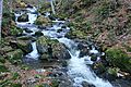
The waterfall drops over 100 metres (330 ft) along a stretch of 715 metres (2,346 ft). Most of Easach Ban is a cascade, meaning the water flows over a series of rocks. However, one special part is a horsetail waterfall. Here, the water drops 16 metres (52 ft) in several steps. About two-thirds of the way down, there is a small pool between sections of the falls.
How the Landscape Formed
The land around Easach Ban has been shaped by incredibly powerful forces over billions of years. The Earth's landmass formed here, and there was a lot of volcanic activity. Continents crashed into each other, building mountains. Huge amounts of erosion (wearing away of land) and glaciation (ice ages) also helped create this landscape.
Easach Ban sits in a deep, steep-sided river canyon. This area is where the high Cape Breton Boreal Plateau meets the lower Central Cape Breton Hills. Big rivers, like the Baddeck River (which Easach Ban is part of), start on the boreal plateau. They then rush down steep slopes, about 300 metres (980 ft) high, before emptying into the Bras d'Or Lakes. The rocks here are very old, including granite, gneiss, and schist.
The Easach Ban canyon is filled with different types of trees. You'll find deciduous trees (which lose their leaves), coniferous trees (like evergreens), and mixed forests. Common trees include sugar maple, yellow birch, beech, white spruce, and balsam fir. Some rare and unusual plants also grow in this canyon.
The Name Uisge Ban
The name Uisge Ban comes from the Gaelic language. It means "white water" (uisge bàn). It might also be linked to the Gaelic word eas, which means waterfall.
The official name for the falls can be a bit confusing. Many maps from the Nova Scotia government and tourist groups use spellings starting with a "U". Sometimes, they even use both "Uisge" and "Uisage" in the same document. However, the only official name listed in Canadian government databases is "Easach Ban". This is also the only name used on official Canadian topographical maps.

Exploring the Falls Trail
You can reach the waterfall by following a walking path called the Falls Trail. The trail is about 3.0 kilometres (1.8 miles) long in total (round trip). It usually takes about one hour to walk the whole trail.
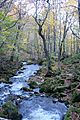
The path first goes through an open field. Then, it follows Falls Brook upstream. You'll walk through a mixed forest and then a mature hardwood forest. This forest has many maple, birch, and beech trees. As you get closer to Uisge Ban Waterfall, the deep stream valley becomes much narrower. At the falls, the gorge walls rise steeply, reaching 150 metres (500 feet) high on both sides.
The first version of the trail was built with help from the Nova Scotia Forest Technicians Association. More recently, improvements were made by Stora Enso and the Nova Scotia Department of Natural Resources.
Gallery
-
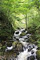
Along the Falls Trail
-
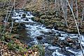
Along the Falls Trail
-
Along the Falls Trail
-
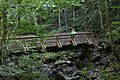
New Bridge on the Falls Trail
-
Along the Falls Trail
-
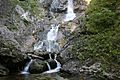
Lower Falls
-
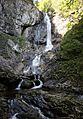
Upper falls at low water
-
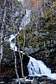
Upper falls in October 2014


