Uisge Ban Falls Provincial Park facts for kids
Quick facts for kids Uisge Ban Falls Provincial Park |
|
|---|---|

Uisge Ban Falls
|
|
| Lua error in Module:Location_map at line 420: attempt to index field 'wikibase' (a nil value). | |
| Type | Provincial Park |
| Location | New Glen, Nova Scotia, Canada |
| Nearest town | Baddeck, Nova Scotia |
| Area | 147.49 hectares (364.5 acres) |
| Operated by | Parks and Recreation Division, Nova Scotia Department of Natural Resources |
| Open | Dawn to dusk, from May 15 to October 12, no facilities in winter (parking at gate only) |
| Status | Undesignated; Operational |
| Hiking trails | Falls Trail, River Trail |
| Website | Uisage Ban Falls Provincial Park |
Uisge Ban Falls Provincial Park is a beautiful park located in Nova Scotia, Canada. You can find it on Cape Breton Island, near the town of New Glen. It's about 14.5 kilometers (9 miles) north of Baddeck.
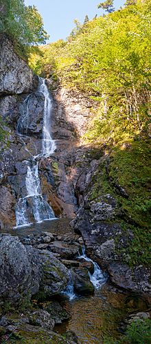
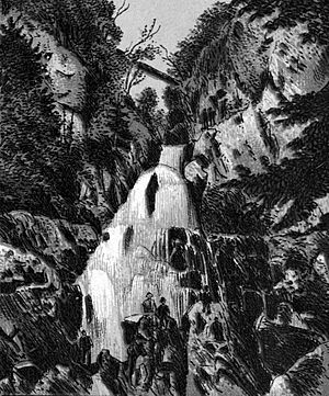
The name "Uisge Ban" comes from a Gaelic phrase that means "white water." This park is a great spot for picnics and hiking. It's managed by the Nova Scotia Department of Natural Resources. The park is home to the amazing Easach Ban Falls.
The trails here are well-kept, and you'll find signs with information and a map at the start of the trails. The park also has parking, picnic tables (some with shelters), and restrooms. The main waterfall is 16 meters (50 feet) tall and easy to reach by trail.
Contents
The Park's Natural History
This section explores the amazing natural features of Uisge Ban Falls Provincial Park. You'll learn about how the land was formed and the different plants that grow here.
How the Land Was Formed
The landscape around Uisge Ban Falls Provincial Park was shaped by incredibly powerful forces over billions of years. Imagine huge volcanoes erupting, continents crashing into each other, and giant mountains forming! Then, over time, massive erosion (when rock and soil are worn away) and glaciation (when glaciers move and carve the land) helped create the landscape you see today.
Uisge Ban Falls Provincial Park sits in a deep, narrow river canyon. This area is where the high Cape Breton Boreal Plateau meets the lower Central Cape Breton Hills. The rocks here are very old, including granite, gneiss, and schist.
Big rivers, like the Baddeck River system (which includes Falls Brook / Easach Ban), start on the high plateau. They then flow down steep slopes, dropping about 300 meters (1,000 feet), before emptying into the Bras d'Or Lakes.
Amazing Plant Life
The canyon of Falls Brook / Easach Ban is filled with different kinds of forests, including trees that lose their leaves (deciduous), trees that stay green all year (coniferous), and mixed forests. Some of the main trees you'll see are sugar maple, yellow birch, beech, white spruce, and balsam fir. You might even find some rare plants here!
Sometimes, the streams here overflow their banks. When this happens, they leave behind rich soil along the edges. Even though these soil patches aren't huge, many beautiful wildflowers love the sunlight and rich ground. Look for Nodding Trilliums, Indian Cucumber, False Solomon's Seal, Clintonia, Starflower, Bunchberry, and False Lily-of-the-Valley. You might also spot small groups of poisonous red baneberry, which add a splash of color.
Exploring the Trails
The park offers two main trails for you to explore, each with its own unique features and views.
The Falls Trail
The Falls Trail is about 3 kilometers (1.9 miles) long and takes about an hour to walk. It starts by crossing a field, then follows Falls Brook upstream. You'll walk through a mixed forest, then a mature hardwood forest with lots of maple, birch, and beech trees. As you get closer to Easach Ban Waterfall, the deep stream valley gets much narrower. At the falls, the gorge walls rise steeply, about 150 meters (500 feet) high on both sides!
The River Trail
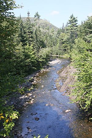
Another trail in the park is The River Trail. It branches off from the Falls Trail and heads north from Falls Brook. This trail is also about 3 kilometers (1.9 miles) long (round trip) and takes about an hour to complete. As you follow the banks of the North Branch Baddeck River, the trail winds through a forest of old sugar maple, yellow birch, and beech trees. Many of these trees are over 100 years old!
Beyond the Main Falls
If you're feeling adventurous, there's another waterfall about 10 meters (33 feet) tall, located about 1.5 kilometers (0.9 miles) upstream from Easach Ban Falls. To reach it, you'll need to hike along the side of the brook, as there isn't a marked trail.
You can also access the top of the ridge above the falls a few hundred meters back downstream. Just be very careful around the high cliffs in this area.
Geocaching Fun
If you enjoy geocaching, you're in luck! There are several geocaches hidden in Uisge Ban Falls Provincial Park. You can find them near the park entrance, along the River Trail to Uisge Ban Falls, and even close to the falls themselves. It's a fun way to explore the park and discover hidden treasures!
Park Hours and Fees
Uisge Ban Falls Provincial Park is open for day use from dawn to dusk, from May 15 to October 12. During the winter, there are no facilities available, and you can only park at the gate. The best part? There is no charge to use the park or its facilities!
 | Stephanie Wilson |
 | Charles Bolden |
 | Ronald McNair |
 | Frederick D. Gregory |


