Uncertain, Texas facts for kids
Quick facts for kids
Uncertain, Texas
|
|
|---|---|

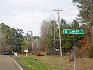
City marker of Uncertain
|
|
| Country | United States |
| State | Texas |
| County | Harrison |
| Area | |
| • Total | 0.54 sq mi (1.39 km2) |
| • Land | 0.54 sq mi (1.39 km2) |
| • Water | 0.00 sq mi (0.00 km2) |
| Elevation | 184 ft (56 m) |
| Population
(2020)
|
|
| • Total | 85 |
| • Density | 171.32/sq mi (66.17/km2) |
| Time zone | UTC-6 (Central (CST)) |
| • Summer (DST) | UTC-5 (CDT) |
| ZIP code |
75661
|
| Area code(s) | 903, 430 |
| FIPS code | 48-74240 |
| GNIS feature ID | 2412128 |
Uncertain is a small city located in Harrison County, Texas, in the United States. It is known for its unique name and sits right next to the beautiful Caddo Lake. In 2020, about 85 people lived in Uncertain.
Contents
A Look Back in Time
Uncertain became an official city in 1961. It is run by a mayor and five aldermen, who are like city council members. They help make decisions for the community.
The city's name, "Uncertain," is quite unusual! People say the name came about because when the first residents were filling out the paperwork to make it a town, they hadn't decided on a name yet. So, they just wrote "Uncertain" in the blank space. And that's how the city got its interesting name!
Where is Uncertain?
Uncertain is in the northeastern part of Harrison County, Texas. It is located at the western end of Caddo Lake. This lake is a large body of water that stretches east into Louisiana.
The city is at the end of Farm to Market Road 2198. This road goes southwest about 5 miles (8 km) to State Highway 43 near Karnack. Uncertain is also about 21 miles (34 km) northeast of Marshall, which is the main city in Harrison County.
The United States Census Bureau says that Uncertain covers a total area of about 0.54 square miles (1.39 square kilometers). Almost all of this area is land.
How Many People Live Here?
| Historical population | |||
|---|---|---|---|
| Census | Pop. | %± | |
| 1970 | 202 | — | |
| 1980 | 176 | −12.9% | |
| 1990 | 194 | 10.2% | |
| 2000 | 150 | −22.7% | |
| 2010 | 94 | −37.3% | |
| 2020 | 85 | −9.6% | |
| U.S. Decennial Census | |||
In the year 2000, there were 150 people living in Uncertain. They lived in 77 households, and 49 of those were families. The population density was about 294 people per square mile.
By 2010, the population had gone down to 94 people. In the most recent count in 2020, there were 85 people living in Uncertain. Most of the people living in the city are white.
Learning in Uncertain
The city of Uncertain is part of the Karnack Independent School District. This district provides education for students in the area.
For students who want to continue their education after high school, Panola College is the assigned community college. This means that most students from Harrison County, including Uncertain, can attend Panola College.
See also
 In Spanish: Uncertain (Texas) para niños
 | William Lucy |
 | Charles Hayes |
 | Cleveland Robinson |


