Unionville, Orange County, New York facts for kids
Quick facts for kids
Unionville
|
|
|---|---|
| Village of Unionville | |

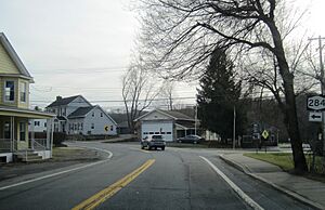
Center of Unionville along NY 284
|
|

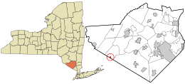
Location in Orange County and the state of New York.
|
|
| Country | United States |
| State | New York |
| County | Orange |
| Incorporated | 1871 |
| Area | |
| • Total | 0.31 sq mi (0.79 km2) |
| • Land | 0.31 sq mi (0.79 km2) |
| • Water | 0.00 sq mi (0.00 km2) |
| Population
(2020)
|
|
| • Total | 592 |
| • Density | 1,934.64/sq mi (747.58/km2) |
| Time zone | UTC-5 (Eastern (EST)) |
| • Summer (DST) | UTC-4 (EDT) |
| Area code(s) | 845 |
| FIPS code | 36-76210 |
| GNIS feature ID | 2391176 |
Unionville is a small village in Orange County, New York, United States. It is the smallest village in Orange County. In 2020, its population was 592 people.
The village is located within the town of Minisink. It is southeast of Port Jervis. Unionville is part of a larger area that includes cities like Poughkeepsie and Newburgh. It is also close to the bigger New York City area.
History of Unionville
The area where Unionville is located was first settled in the early 1700s. Around 1820, the settlement became known as Unionville. People say the name "Unionville" was chosen after a disagreement about land was settled peacefully.
Unionville officially became a village in 1871. It used to be an important place for business in the area. This changed as new ways of transportation developed. The Middletown and Unionville Railroad used to carry farm products, especially milk. It also took high school students to school in the first half of the 1900s.
By World War II, roads had improved. A new high school was built far from the train tracks. This led to the end of train services for passengers and goods. Passenger train service stopped completely in 1968.
Geography of Unionville
Unionville is located at 41°18′1″N 74°33′42″W / 41.30028°N 74.56167°W.
According to the United States Census Bureau, the village covers a total area of about 0.2 square miles (0.6 square kilometers). All of this area is land.
The village is situated on NY Route 284. The famous Appalachian Trail runs just south of the village. This trail follows the border between New York and New Jersey. Unionville is also right next to the Town of Wantage in New Jersey.
Population Facts
| Historical population | |||
|---|---|---|---|
| Census | Pop. | %± | |
| 1880 | 316 | — | |
| 1890 | 316 | 0.0% | |
| 1900 | 454 | 43.7% | |
| 1910 | 351 | −22.7% | |
| 1920 | 402 | 14.5% | |
| 1930 | 438 | 9.0% | |
| 1940 | 387 | −11.6% | |
| 1950 | 454 | 17.3% | |
| 1960 | 511 | 12.6% | |
| 1970 | 576 | 12.7% | |
| 1980 | 574 | −0.3% | |
| 1990 | 548 | −4.5% | |
| 2000 | 536 | −2.2% | |
| 2010 | 612 | 14.2% | |
| 2020 | 592 | −3.3% | |
| U.S. Decennial Census | |||
In 2000, there were 536 people living in Unionville. There were 197 households and 140 families. The population density was about 2,140 people per square mile.
About 36.5% of households had children under 18 living with them. Many households (52.8%) were married couples living together. About 22.3% of all households were made up of individuals living alone.
The people in Unionville were spread out by age. About 26.3% were under 18 years old. About 10.3% were 65 years or older. The average age was 38 years.
The average income for a household in the village was $37,222. For families, the average income was $41,000. About 8.4% of the population lived below the poverty line. This included 6.3% of those under 18.
See also
 In Spanish: Unionville (condado de Orange, Nueva York) para niños
 | Precious Adams |
 | Lauren Anderson |
 | Janet Collins |


