Unionville, Iowa facts for kids
Quick facts for kids
Unionville, Iowa
|
|
|---|---|

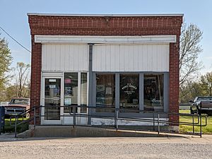
The post office building in Unionville, Iowa
|
|

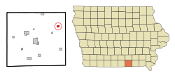
Location of Unionville, Iowa
|
|
| Country | |
| State | |
| County | Appanoose |
| Area | |
| • Total | 0.75 sq mi (1.95 km2) |
| • Land | 0.75 sq mi (1.95 km2) |
| • Water | 0.00 sq mi (0.00 km2) |
| Elevation | 948 ft (289 m) |
| Population
(2020)
|
|
| • Total | 75 |
| • Density | 99.73/sq mi (38.53/km2) |
| Time zone | UTC-6 (Central (CST)) |
| • Summer (DST) | UTC-5 (CDT) |
| ZIP code |
52594
|
| Area code(s) | 641 |
| FIPS code | 19-79680 |
| GNIS feature ID | 2397089 |
Unionville is a small city located in Appanoose County, Iowa, in the United States. According to the 2020 census, 75 people lived there. It is a quiet place with a long history in Iowa.
Contents
History of Unionville
Unionville is believed to be the oldest settlement in Appanoose County. The first people arrived and settled here in 1843. A few years later, in 1846, the first school was built.
A person named J. F. Stratton officially mapped out Unionville in 1848. He did this on land that was close to an old trail used by soldiers and the famous Mormon trail.
The city of Unionville was officially founded in 1849. Its name probably comes from the idea of the "federal union" of the United States. Unionville became an official city in 1922.
Geography of Unionville
Unionville is located in Iowa. The United States Census Bureau says that the city covers a total area of about 0.75 square miles (1.95 square kilometers). All of this area is land, meaning there are no large lakes or rivers within the city limits.
Population and People
| Historical Populations | ||
|---|---|---|
| Year | Pop. | ±% |
| 1860 | 178 | — |
| 1870 | 183 | +2.8% |
| 1880 | 196 | +7.1% |
| 1930 | 221 | +12.8% |
| 1940 | 253 | +14.5% |
| 1950 | 204 | −19.4% |
| 1960 | 185 | −9.3% |
| 1970 | 161 | −13.0% |
| 1980 | 150 | −6.8% |
| 1990 | 133 | −11.3% |
| 2000 | 127 | −4.5% |
| 2010 | 102 | −19.7% |
| 2020 | 75 | −26.5% |
| Source: and Iowa Data Center Source: |
||
Unionville in 2020
In 2020, the census showed that 75 people lived in Unionville. These people lived in 37 different homes, and 23 of these were families.
Most of the people living in Unionville were White (96.0%). A very small number were from other backgrounds. About 1.3% of the population identified as Hispanic or Latino.
The average age of people in Unionville was 49.8 years old. About 18.7% of the residents were under 20 years old. A larger group, 32.0%, were 65 years old or older. Slightly more than half of the residents were female (54.7%), and 45.3% were male.
Unionville in 2010
Back in 2010, the census counted 102 people living in Unionville. There were 49 households, and 29 of them were families. The population density was about 136 people per square mile.
At that time, 100% of the city's population was White. About 3.9% of the people were Hispanic or Latino.
The average age in 2010 was 51.8 years. About 17.6% of the residents were under 18 years old. The city had slightly more females (51.0%) than males (49.0%).
See also
 In Spanish: Unionville (Iowa) para niños
 | John T. Biggers |
 | Thomas Blackshear |
 | Mark Bradford |
 | Beverly Buchanan |


