
Upper Montclair, New Jersey facts for kids
Quick facts for kids
Upper Montclair, New Jersey
|
|
|---|---|
.jpg)
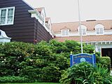
Upper Montclair business district
|
|
 |
|

Upper Montclair, New Jersey
Location in Essex County, New Jersey

Upper Montclair, New Jersey
Location in New Jersey

Upper Montclair, New Jersey
Location in the United States
|
|
| Country | |
| State | |
| County | Essex |
| Township | Montclair |
| Area | |
| • Total | 2.38 sq mi (6.17 km2) |
| • Land | 2.38 sq mi (6.16 km2) |
| • Water | 0.00 sq mi (0.00 km2) 0.04% |
| Elevation | 322 ft (98 m) |
| Population
(2020)
|
|
| • Total | 13,146 |
| • Density | 5,523.53/sq mi (2,132.43/km2) |
| Time zone | UTC−05:00 (Eastern (EST)) |
| • Summer (DST) | UTC−04:00 (EDT) |
| ZIP Codes |
07043
|
| Area code(s) | 862/973 |
| FIPS code | 34-75020 |
| GNIS feature ID | 2584034 |
Upper Montclair is a special area, like a neighborhood, located within the larger town of Montclair in Essex County, New Jersey. Even though it has its own ZIP Code (07043), it's not a separate town. In 2010, about 11,565 people lived here.
Contents
Discovering Upper Montclair's Past
Upper Montclair started as a small farming community in the early 1700s. It was first known as Speertown, named after an early Dutch settler, John Speer. For many years, it remained a quiet, rural area.
The modern town of Montclair, which includes Upper Montclair, officially became a township in 1868. This happened when it separated from Bloomfield Township.
Upper Montclair's Location and Size
Upper Montclair is located in the northern part of Montclair. It covers about 40% of the entire Montclair township. The area is about 2.5 square miles (6.5 square kilometers) in total. Most of this area is land, with only a tiny bit of water.
Who Lives in Upper Montclair?
| Historical population | |||
|---|---|---|---|
| Census | Pop. | %± | |
| 2020 | 13,146 | — | |
| U.S. Decennial Census | |||
In 2010, about 11,565 people lived in Upper Montclair. The population density was about 4,561 people per square mile. Most residents were White (83.99%), with smaller percentages of Black or African American (6.46%), Asian (4.18%), and people of two or more races (3.97%). About 5.61% of the population was Hispanic or Latino.
Many families live in Upper Montclair. About 44% of households had children under 18 years old. The average household had about 2.76 people. The average age of residents was 42.1 years.
Learning in Upper Montclair
.jpg)
Upper Montclair is part of the Montclair Public Schools system. A good number of the district's schools are found right here. These include Bradford Elementary and Northeast Elementary, which are two of Montclair's seven elementary schools.
Mt. Hebron Middle School is also in Upper Montclair. In 2016, it was renamed Buzz Aldrin Middle School. This was done to honor the famous astronaut, Buzz Aldrin, who grew up in Montclair. Part of Montclair State University's campus is also located in Upper Montclair.
There are also private schools in the area. These include Lacordaire Academy and St. Cassian School.
Getting Around Upper Montclair
Upper Montclair has good ways to get around, connecting it to the rest of New Jersey and New York City. You can use public transportation like buses and trains, both run by New Jersey Transit.
Train Stations

The New Jersey Transit Montclair-Boonton Line train runs through Upper Montclair. There are three train stations in Upper Montclair: Upper Montclair, Mountain Avenue, and Montclair Heights. These stations are quite close to each other.
Bus Routes

The area is also served by NJ Transit's bus route 28. This bus travels along Valley Road through Montclair, Glen Ridge, and Bloomfield, all the way to Downtown Newark.
Roads and Highways
Upper Montclair has good road connections to nearby towns like Cedar Grove, Little Falls, Clifton, and Bloomfield. Just north of the neighborhood, you can find major highways like U.S. Route 46 and New Jersey Route 3.
Shopping and Local Businesses
The main shopping area in Upper Montclair is called the Upper Montclair Business District. Here, you'll find many restaurants and shops. Unlike some other shopping areas in Montclair, this district has several well-known chain stores alongside local businesses.
A unique spot is the Montclair Station Restaurant & Bar, which opened in the historic Upper Montclair train station building. The area also has Anderson Park and a post office.
Parks and Green Spaces
Upper Montclair is home to many beautiful parks and nature areas. You can visit Anderson Park, Yantacaw Brook Park, and the Bonsal Nature Reserve. There's also Mountainside Park and the famous Presby Memorial Iris Gardens. Parts of Mills Reservation and Brookdale Park are also nearby.
For swimming, Upper Montclair has the Mountainside Public Pool. This is the largest of the three public pools in Montclair.
Famous People from Upper Montclair
Many interesting people have lived in or are connected to Upper Montclair:


- Buzz Aldrin (born 1930): A famous astronaut who was the second person to walk on the Moon.
- Yael Averbuch (born 1986): A professional soccer player.
- Margaret Colin (born 1958): An actress.
- Justin Deas (born 1948): An actor.
- Joe Walsh (born 1947): A well-known singer, songwriter, and musician.
Images for kids
- Upper Montclair Gallery
-
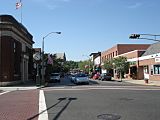
Business district in Upper Montclair, which is around the intersection of Valley Road and Bellevue Avenue
-
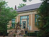
Upper Montclair's library, which is called the Bellevue Branch
-
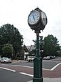
A landmark in Upper Montclair, a clock owned by Chase bank that is situated in the center of town and was installed around 1910. About 2004, the clock was sent away for needed refurbishment.
-
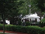
A movie being filmed in Upper Montclair
-
the Montclair Women's Club

.jpg)


.jpg)

.jpg)
See also
 In Spanish: Upper Montclair (Nueva Jersey) para niños
