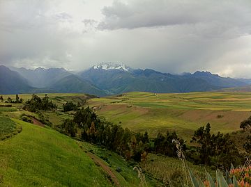
Urubamba mountain range facts for kids
Quick facts for kids Urubamba mountain range |
|
|---|---|

Chicón (center) as seen from the south west
|
|
| Highest point | |
| Peak | Veronica, Sahuasiray |
| Elevation | 5,818 m (19,088 ft) |
| Dimensions | |
| Length | 30 km (19 mi) N-S |
| Geography | |
| Country | Peru |
| State/Province | Cusco Region |
| Parent range | Andes |
The Urubamba mountain range is a beautiful chain of mountains in the Cusco Region of Peru. Its name might come from the Quechua language, where uru means spider and pampa means a flat plain. This mountain range stretches for about 30 kilometers in a northwest direction. It is part of the larger Andes mountain system.
Understanding Mountain Names
Many names in the Urubamba mountain range come from ancient languages like Quechua and Aymara. For a long time, these names were spelled using Spanish rules. However, these spellings didn't always match how the words are truly said in Quechua or Aymara.
Peru now has a law (Law 29735) that helps protect and promote its original languages. Because of this, the way mountain names are spelled is slowly changing. The goal is to make sure the names on official maps are spelled correctly in the native languages. This helps keep these important languages alive.
You might notice some older spellings have "hua" or "hui" instead of "wa" or "wi". Also, letters like "e", "o", "ca", "cu", "qu", and certain diphthongs (two vowel sounds together) might be spelled differently in the new, correct way.
Tall Peaks of Urubamba
The Urubamba mountain range is home to many impressive peaks. The two highest mountains are Veronica, which stands at about 5,893 meters (19,334 feet) tall, and Sahuasiray, reaching about 5,818 meters (19,088 feet).
Here is a list of other notable mountains in the range:
- Chicón, 5,530 metres (18,143 ft)
- Sirihuani, 5,399 metres (17,713 ft)
- Halancoma, 5,367 metres (17,608 ft)
- Huajayhuillca, 5,361 metres (17,589 ft)
- Marconi, 5,340 metres (17,520 ft)
- Pumahuanca, 5,318 metres (17,448 ft)
- Ancasmarca, 5,198 metres (17,054 ft)
- Condorhuachana, 5,073 metres (16,644 ft)
- Huamanchoque, 5,156 metres (16,916 ft)
- Ccerayoc, 5,092 metres (16,706 ft)
- Capacsaya, 5,044 metres (16,549 ft)
- Huacratanca, 5,024 metres (16,483 ft)
- Ajosune, 5,000 metres (16,404 ft)
- Huarmaripayoc, 5,000 metres (16,404 ft)
- Pitusiray, 4,991 metres (16,375 ft)
- Canchacanchajasa, 4,987 metres (16,362 ft)
- Azulorjo, 4,958 metres (16,266 ft)
- Chaquicocha, 4,895 metres (16,060 ft)
- Parorjo, 4,891 metres (16,047 ft)
- Apurinru, 4,880 metres (16,010 ft)
- Pucajasa, 4,800 metres (15,748 ft)
- Pumacallanca, 4,800 metres (15,748 ft)
- Yana Orjo, 4,800 metres (15,748 ft)
- Yanaorcco (Lares), 4,800 metres (15,748 ft)
- Pucaorjo, 4,776 metres (15,669 ft)
- Sutoc, 4,735 metres (15,535 ft)
- Patacancha, 4,666 metres (15,308 ft)
- Coscojahuarina, 4,623 metres (15,167 ft)
- Jatun Huiscana, 4,600 metres (15,092 ft)
- Llamayojcasa, 4,600 metres (15,092 ft)
- Coscojahuarina (Calca), 4,600 metres (15,092 ft)
- Quellorjo, 4,600 metres (15,092 ft)
- Puquiopata, 4,400 metres (14,436 ft)
- Yurac Orjo, 4,400 metres (14,436 ft)
- Maquimaquiyoc, 4,200 metres (13,780 ft)
See also
 In Spanish: Cordillera Urubamba para niños
 | Valerie Thomas |
 | Frederick McKinley Jones |
 | George Edward Alcorn Jr. |
 | Thomas Mensah |

