Utica, Indiana facts for kids
Quick facts for kids
Utica, Indiana
|
|
|---|---|
| Town of Utica | |

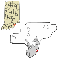
Location of Utica in Clark County, Indiana.
|
|
| Country | United States |
| State | Indiana |
| County | Clark |
| Township | Utica |
| Area | |
| • Total | 1.44 sq mi (3.73 km2) |
| • Land | 1.19 sq mi (3.08 km2) |
| • Water | 0.25 sq mi (0.65 km2) |
| Elevation | 522 ft (159 m) |
| Population
(2020)
|
|
| • Total | 860 |
| • Density | 723.30/sq mi (279.25/km2) |
| Time zone | UTC-5 (Eastern (EST)) |
| • Summer (DST) | UTC-4 (EDT) |
| ZIP code |
47130
|
| Area code(s) | 812 |
| FIPS code | 18-78110 |
| GNIS feature ID | 2397708 |
| Website | https://uticaindiana.org/ |
Utica is a small town located in Clark County, Indiana, United States. It is part of Utica Township. In 2020, about 860 people lived there.
Contents
History of Utica
Early Days as a Ferry Crossing
From 1794 to 1825, Utica was a very important place for crossing the Ohio River. People used ferries to get from one side to the other. It was safer to cross here than at Jeffersonville. This was because ferry operators in Jeffersonville were not as experienced.
James Noble Wood founded Utica. He was also the first person to run a ferry in this area. He even served as a judge in the "Indian Territory" during that time. This was when Indiana was still a territory, not yet a state.
Growth and Development After a Flood
In 1997, a big flood hit Utica. After the flood, the town had to make its building rules stronger. This was necessary to get money from the Federal Emergency Management Agency (FEMA). FEMA helps communities recover from disasters. The Indiana Department of Natural Resources (DNR) also provided funds.
Because of these new rules, Utica started to grow. However, the town is now surrounded by other big projects. These include the Port of Indiana – Jeffersonville. There is also a new bridge over the Ohio River, which opened in 2016. The River Ridge Commerce Center is another large development nearby. These projects mean Utica might not grow much more in the future.
Geography of Utica
Utica covers a total area of about 1.45 square miles (3.73 square kilometers). Most of this area is land, about 1.19 square miles (3.08 square kilometers). The rest is water, which is about 0.25 square miles (0.65 square kilometers).
Population in Utica
| Historical population | |||
|---|---|---|---|
| Census | Pop. | %± | |
| 1880 | 525 | — | |
| 1970 | 644 | — | |
| 1980 | 501 | −22.2% | |
| 1990 | 411 | −18.0% | |
| 2000 | 591 | 43.8% | |
| 2010 | 776 | 31.3% | |
| 2020 | 860 | 10.8% | |
| U.S. Decennial Census | |||
Population Changes Over Time
The population of Utica has changed quite a bit over the years. In 1880, there were 525 people living there. By 1990, the population had dropped to 411. However, it started to grow again after that.
Utica's Population in 2010
According to the census from 2010, 776 people lived in Utica. There were 328 households, which are groups of people living together. About 212 of these were families.
Most of the people in Utica were White, making up almost 90% of the population. There were also people who identified as African American, Native American, and Asian. Some people were from other races or from two or more races. About 3.4% of the population was Hispanic or Latino.
The average age of people in Utica in 2010 was 43.3 years old. About 19% of residents were under 18 years old. Around 14% were 65 years old or older. The town had slightly more females than males.
See also
In Spanish: Utica (Indiana) para niños
 | Charles R. Drew |
 | Benjamin Banneker |
 | Jane C. Wright |
 | Roger Arliner Young |

