Van Rensselaer Island facts for kids
| Geography | |
|---|---|
| Location | Hudson River |
| Coordinates | 42°38′46″N 73°44′35″W / 42.64611°N 73.74306°W |
| Highest elevation | 25 ft (7.6 m) |
| Administration | |
| City | Rensselaer, New York |
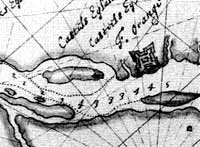
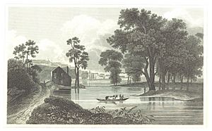
Van Rensselaer Island was once an island in the Hudson River in New York. It was located across from the city of Albany. Over time, this island was known by several names. Some of these names included de Laet's Island, Kalebacker's Island, and Boston Island. The names Boston Island and B&A Island came from the Boston and Albany Railroad.
The island stretched from a small stream called Mill Creek north to the Livingston Avenue Bridge. Today, Van Rensselaer Island is no longer an island. It is now connected to the city of Rensselaer.
Van Rensselaer Island was also a name sometimes used for Westerlo Island in Albany. This area is now part of the Port of Albany–Rensselaer.
Island History
The island's name changed many times over 400 years. Henry Hudson first saw it when he explored the area where Albany is now. One old name was Kalebacker's Island. This name might come from a Dutch term meaning "mean fellow." The Dutch used this term for Native Americans who had guns and were seen as troublesome.
Early Settlements
A group of Native Americans moved to the island. They settled there after the Dutch built Fort Orange across the Hudson River. They likely moved to trade with the Dutch. They had a fort, a village, and fields for growing crops. This site is important for archaeologists.
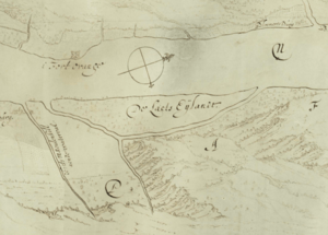
The name De Laets Eylandt (de Laet's Island) was given in the 1630s. It honored Joannes de Laet. This name was given by Kiliaen van Rensselaer. He was the first Patroon of the Rensselaerswyck. This was a large estate that covered what are now Albany and Rensselaer counties.
In 1658, Jan Baptist van Rensselaer leased land on the island. He leased the tilled land to Arent Adriessen. The island was called "the island opposite the center of the village of Beverwyck". The lease was for four years.
Railroad Era

In the 1800s, the island became very important for the Boston and Albany Railroad (B&A). It had a passenger station, repair shops, and freight buildings. It also had a roundhouse and a coach yard. The island was a place where passengers and goods switched between the B&A and the New York Central Railroad. This is why it became known as Boston Island.
A ferry used to take people between the island and downtown Albany. The railroad changed the island's shape. They built docks for coal and grain. They also dug a channel that split the island in half. In 1871, the Maiden Lane Bridge was built. This bridge replaced the ferry.
When the New York Central and B&A railroads merged in 1900, the island became less active. Many buildings were torn down. In 1903, the channel that separated the island from the mainland was filled in. Sand from the Hudson River was used for this. Also in 1903, the New York Central Railroad bought the island from the van Rensselaer family.
Modern Development
The Maiden Lane Bridge and all the old railroad buildings were removed in 1969. This was to make way for the Rensselaer City School District's campus. Two years earlier, ramps for the Dunn Memorial Bridge were built on the southern part of the island.
The school campus area is now planned for a new project. It will be a mixed-use waterfront community. The developers built a new school campus in a different part of the city. The new project on the island is called de Laet's Landing. This name honors Johan de Laet and the island's original name.
De Laet's Landing is a very large project. It will include offices, shops, restaurants, and apartments. There will also be a walkway along the Hudson River and a marina. It is designed to be like Baltimore's Inner Harbor. The project faced a challenge when the New York State Department of Environmental Conservation said the marina design needed changes. This was to protect "water celery" along the shoreline. Water celery is important for clean water and fish habitat. Despite this, the project has received grants and plans to move forward. As of 2014, construction had not yet started, but there were talks about building a casino there.
Island Geology
Today, Van Rensselaer Island is no longer a true island. The channel on its east side has been filled in. The land is made of old bedrock called Normanskill shale. The soil is mostly sandy dirt that was dredged from the Hudson River.
In the 1600s, the island was probably only about 10 feet (3 meters) above the river. Today, it is about 25 feet (7.6 meters) high. Mill Creek flows into the Hudson River at the southern end of the area. In the past, Quackenderry Creek also flowed into the channel between the island and the mainland. Today, this creek still flows through the area.


