
Vanderbilt, Michigan facts for kids
Quick facts for kids
Vanderbilt, Michigan
|
|
|---|---|
|
Village
|
|
| Village of Vanderbilt | |
.jpg)
Looking west along Main Street
|
|
| Nickname(s):
Gateway to the Pigeon River Country Forest
|
|
,_MI_location.png)
Location within Otsego County
|
|

Vanderbilt, Michigan
Location in Michigan

Vanderbilt, Michigan
Location in the United States
|
|
| Country | United States |
| State | Michigan |
| County | Otsego |
| Township | Corwith |
| Settled | 1875 |
| Incorporated | 1901 |
| Government | |
| • Type | Village council |
| Area | |
| • Total | 1.09 sq mi (2.82 km2) |
| • Land | 1.09 sq mi (2.82 km2) |
| • Water | 0.00 sq mi (0.00 km2) |
| Elevation | 1,096 ft (334 m) |
| Population
(2020)
|
|
| • Total | 498 |
| • Density | 456.46/sq mi (176.29/km2) |
| Time zone | UTC-5 (Eastern (EST)) |
| • Summer (DST) | UTC-4 (EDT) |
| ZIP code(s) |
49795
|
| Area code(s) | 989 |
| FIPS code | 26-81700 |
| GNIS feature ID | 1615504 |
Vanderbilt is a small village located in Otsego County in the U.S. state of Michigan. In 2020, about 498 people lived there. The village is part of Corwith Township.
Vanderbilt holds a special record for being the coldest place in Michigan. On February 9, 1934, the temperature dropped to an amazing −51 °F (−46 °C)!
Contents
History of Vanderbilt
The area where Vanderbilt now stands was first settled around 1875. This happened because the Michigan Central Railroad planned to build a railway line north from Gaylord.
The settlement was named after Cornelius Vanderbilt. He was a famous businessman who owned land in Corwith Township. The railway line reached Vanderbilt by 1881. The village officially became a village in 1901.
Geography and Location
According to the U.S. Census Bureau, the village covers a total area of about 1.09 square miles (2.82 km2). All of this area is land.
Main Roads in Vanderbilt
- I-75 is a major highway that runs north and south along the western edge of the village. You can get onto I-75 from exit 290 (Mill Street).
Vanderbilt's Climate
Vanderbilt has a climate with big changes in temperature between seasons. Summers are warm to hot, and often humid. Winters are cold, and sometimes very cold. This type of weather is called a humid continental climate.
As mentioned, Vanderbilt set the record for Michigan's coldest temperature on February 9, 1934, when it reached −51 °F (−46 °C). The highest temperature ever recorded in Michigan was 112 °F (44 °C) in Mio on July 13, 1936.
| Climate data for Vanderbilt 11 ENE, Michigan (1991–2020 normals, extremes 1913–present) | |||||||||||||
|---|---|---|---|---|---|---|---|---|---|---|---|---|---|
| Month | Jan | Feb | Mar | Apr | May | Jun | Jul | Aug | Sep | Oct | Nov | Dec | Year |
| Record high °F (°C) | 57 (14) |
60 (16) |
86 (30) |
90 (32) |
96 (36) |
105 (41) |
108 (42) |
102 (39) |
98 (37) |
89 (32) |
76 (24) |
63 (17) |
108 (42) |
| Mean daily maximum °F (°C) | 25.8 (−3.4) |
28.4 (−2.0) |
38.8 (3.8) |
52.0 (11.1) |
66.9 (19.4) |
76.5 (24.7) |
79.9 (26.6) |
78.4 (25.8) |
69.9 (21.1) |
55.6 (13.1) |
42.3 (5.7) |
31.4 (−0.3) |
53.8 (12.1) |
| Daily mean °F (°C) | 16.8 (−8.4) |
17.0 (−8.3) |
25.9 (−3.4) |
38.8 (3.8) |
52.4 (11.3) |
61.8 (16.6) |
65.6 (18.7) |
64.0 (17.8) |
56.1 (13.4) |
44.5 (6.9) |
34.1 (1.2) |
24.0 (−4.4) |
41.8 (5.4) |
| Mean daily minimum °F (°C) | 7.8 (−13.4) |
5.7 (−14.6) |
13.1 (−10.5) |
25.5 (−3.6) |
37.8 (3.2) |
47.0 (8.3) |
51.3 (10.7) |
49.7 (9.8) |
42.2 (5.7) |
33.4 (0.8) |
25.8 (−3.4) |
16.5 (−8.6) |
29.6 (−1.3) |
| Record low °F (°C) | −40 (−40) |
−51 (−46) |
−39 (−39) |
−13 (−25) |
10 (−12) |
20 (−7) |
27 (−3) |
24 (−4) |
18 (−8) |
6 (−14) |
−17 (−27) |
−37 (−38) |
−51 (−46) |
| Average precipitation inches (mm) | 2.18 (55) |
1.49 (38) |
1.78 (45) |
3.06 (78) |
2.92 (74) |
3.03 (77) |
2.95 (75) |
3.51 (89) |
3.37 (86) |
3.52 (89) |
2.42 (61) |
2.15 (55) |
32.38 (822) |
| Average snowfall inches (cm) | 25.9 (66) |
15.3 (39) |
11.4 (29) |
5.7 (14) |
0.2 (0.51) |
0.0 (0.0) |
0.0 (0.0) |
0.0 (0.0) |
0.0 (0.0) |
0.8 (2.0) |
7.1 (18) |
17.5 (44) |
83.9 (213) |
| Average precipitation days (≥ 0.01 in) | 16.7 | 11.8 | 11.1 | 11.0 | 11.2 | 9.8 | 10.1 | 9.9 | 10.9 | 14.6 | 13.2 | 15.1 | 145.4 |
| Average snowy days (≥ 0.1 in) | 15.9 | 12.8 | 8.0 | 3.4 | 0.1 | 0.0 | 0.0 | 0.0 | 0.0 | 0.7 | 5.9 | 15.8 | 59.6 |
| Source: NOAA | |||||||||||||
Education in Vanderbilt
Vanderbilt has its own school district called Vanderbilt Area Schools. This district serves not only the village but also a larger area around it. This includes all of Corwith Township and parts of other nearby townships.
Population and People
| Historical population | |||
|---|---|---|---|
| Census | Pop. | %± | |
| 1890 | 370 | — | |
| 1910 | 523 | — | |
| 1920 | 394 | −24.7% | |
| 1930 | 456 | 15.7% | |
| 1940 | 405 | −11.2% | |
| 1950 | 410 | 1.2% | |
| 1960 | 509 | 24.1% | |
| 1970 | 522 | 2.6% | |
| 1980 | 525 | 0.6% | |
| 1990 | 605 | 15.2% | |
| 2000 | 587 | −3.0% | |
| 2010 | 562 | −4.3% | |
| 2020 | 498 | −11.4% | |
| U.S. Decennial Census | |||
Vanderbilt's Population in 2020
In 2020, the village had 498 people living in 207 households. The population density was about 456 people per square mile. Most of the people (94.8%) were White. About 1.9% were African American, and 0.22% were Native American. About 2.58% of the people were from two or more races. A small number (0.64%) were Hispanic or Latino.
About 21.4% of households had children under 18. Many households (52.1%) were married couples living together. The average household had 2.44 people, and the average family had 2.90 people.
The average age in the village was 45 years old. About 21.4% of residents were under 18. About 17.1% were 65 years or older. The village had slightly more males (59.1%) than females (40.9%).
Vanderbilt's Population in 2010
In 2010, there were 562 people living in Vanderbilt. There were 237 households and 145 families. The population density was about 497 people per square mile. Most residents (95.6%) were White. About 0.7% were African American, and 0.9% were Native American. About 2.8% of people were from two or more races. About 0.9% of the population was Hispanic or Latino.
About 26.6% of households had children under 18. Many households (45.6%) were married couples. The average household size was 2.37 people. The average family size was 3.01 people.
The average age in the village was 44 years. About 21.7% of residents were under 18. About 18.1% were 65 years or older. The village had slightly more females (51.2%) than males (48.8%).
Images for kids
-
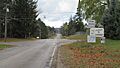
Entrance sign along Main Street
-
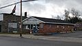
U.S. Post Office in Vanderbilt
-
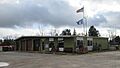
Vanderbilt village office
-
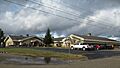
Vanderbilt Area Schools


.jpg)
See also
 In Spanish: Vanderbilt (Míchigan) para niños
