Vessels of the Lakes Route facts for kids
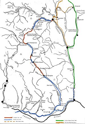
The Lakes Route was an important travel path in British Columbia, Canada. It was also called the Douglas Road. This route was one of the first official ways to get into the interior of BC from the Lower Mainland area. It followed the Fraser River.
People also knew it as the Douglas-Lillooet Trail. The route used a mix of wagon roads and lake travel. Different boats were used on the lakes. These included steamboats, rafts, and later, boats with diesel engines. People used the lakes for trade, travel, and moving heavy goods. This continued until after World War II.
The route started at Port Douglas on Harrison Lake. Harrison Lake connects to the Fraser River. This meant boats could come from the Strait of Georgia and Victoria. The Lakes Route had four main lakes. These were Little Lillooet Lake, Lillooet Lake, Anderson Lake, and Seton Lake.
The end of Seton Lake was close to the Fraser River. Today, this is the town of Lillooet. From there, the Old Cariboo Road continued north. This road was built by Gustavus Blin Wright. It went to Alexandria. This helped people get to the goldfields in the Cariboo.
The Douglas Road and Wright's road were the main ways north. They carried many goods and travelers. However, traffic on the Lakes Route slowed down after 1864. This was when the Cariboo Road from Yale opened. This new road bypassed the Lakes Route entirely.
Even so, communities like Pemberton still used the Lakes Route. They depended on Lillooet for many services. So, passenger and freight services continued on a smaller scale. This was especially true on Seton and Anderson Lakes.
Later, gold mining in the Bridge River area grew. Heavy equipment needed to be moved. Barges were used on the lakes for this. The Pacific Great Eastern Railway was also built. It ran along the north shores of these lakes. Its construction also used small boats. After World War II, the Bridge River Power Project began. This hydro project also used lake transport.
The Royal Engineers made some changes to the route. They raised Little Lillooet Lake slightly. This connected it to Lillooet Lake. It removed the need for a short portage (carrying boats over land). The main port on Lillooet Lake moved south. It went to what was once the end of Little Lillooet Lake.
Boats on Little Lillooet and Lillooet Lakes
- SS Prince of Wales
- SS Prince Lee Boo
Boats on Anderson Lake
- Lady of the Lake Steamer built for Chapman & Company in 1860.
Boats on Seton Lake
- MV Champion
- Minne-ha-ha
- Bluebird
- Marshall's Ferry
 | Janet Taylor Pickett |
 | Synthia Saint James |
 | Howardena Pindell |
 | Faith Ringgold |


