Victoria, Minnesota facts for kids
Quick facts for kids
Victoria
|
|
|---|---|

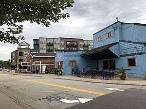
Downtown Victoria
|
|

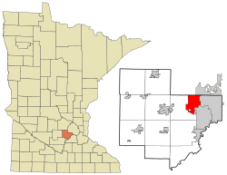
Location of the city of Victoria
within Carver County, Minnesota |
|
| Country | United States |
| State | Minnesota |
| County | Carver |
| Area | |
| • Total | 10.69 sq mi (27.70 km2) |
| • Land | 8.71 sq mi (22.57 km2) |
| • Water | 1.98 sq mi (5.13 km2) |
| Elevation | 958 ft (292 m) |
| Population
(2020)
|
|
| • Total | 10,546 |
| • Estimate
(2021)
|
11,042 |
| • Density | 1,210.38/sq mi (467.34/km2) |
| Time zone | UTC-6 (CST) |
| • Summer (DST) | UTC-5 (CDT) |
| ZIP code |
55386
|
| Area code(s) | 952 |
| FIPS code | 27-67036 |
| GNIS feature ID | 2397135 |
Victoria is a city in Carver County, Minnesota, United States. In 2020, about 10,546 people lived there.
Contents
Exploring Victoria's Geography
Victoria covers about 9.79 square miles (25.36 square kilometers). Most of this area is land, with some lakes and water bodies.
Two main roads, Highway 5 and Highway 7, pass through Victoria.
Victoria is often called "The City of Lakes and Parks." This is because it has over 200 acres (0.81 square kilometers) of protected land. It also has 13 parks and nine lakes within its city limits.
The city is also home to the large 1,800-acre (7.3 square kilometers) Carver Park Reserve. This is a great place for outdoor activities.
In the 1850s, many farmers from Germany, Switzerland, and the Netherlands moved to Victoria. They were attracted by the rich soil, which was perfect for farming.
Victoria's Early History
The first settler in Victoria is thought to be Michael Diethelm. He built a shelter for his family in 1851. This was near where the St. Victoria Church stands today.
The city gets its name from this church. The church was built in 1857 on 30 acres (0.12 square kilometers) of land. It is located just north of Lake Bavaria.
A year later, steamboats started bringing supplies to the early settlers from St. Paul. The community grew as more farmers arrived.
Also in 1858, the Laketown Moravian Brethren's Church was built. This church is now a historic site. Over time, steamboats and the railroad helped Victoria become a busy and successful community.
Population Changes Over Time
| Historical population | |||
|---|---|---|---|
| Census | Pop. | %± | |
| 1920 | 206 | — | |
| 1930 | 240 | 16.5% | |
| 1940 | 276 | 15.0% | |
| 1950 | 302 | 9.4% | |
| 1960 | 425 | 40.7% | |
| 1970 | 850 | 100.0% | |
| 1980 | 1,425 | 67.6% | |
| 1990 | 2,354 | 65.2% | |
| 2000 | 4,025 | 71.0% | |
| 2010 | 7,345 | 82.5% | |
| 2020 | 10,546 | 43.6% | |
| 2021 (est.) | 11,042 | 50.3% | |
| U.S. Decennial Census 2020 Census |
|||
Victoria's Population in 2010
In 2010, the city of Victoria had 7,345 people. There were 2,435 households, and 2,055 families lived there. The city had about 917 people per square mile (354 people per square kilometer).
Most of the people living in Victoria were White (95.6%). There were also smaller groups of African American, Native American, and Asian residents. About 2.0% of the population identified as Hispanic or Latino.
Many households (49.4%) had children under 18 living with them. Most households (76.7%) were married couples. The average household had about 3 people.
The average age in Victoria was 38.9 years old. About 32.9% of residents were under 18. About 8.5% were 65 years or older. The population was almost evenly split between males (49.7%) and females (50.3%).
Schools in Victoria
Victoria has several schools for students.
- Elementary School: Victoria Elementary is part of District 112 schools.
- High Schools:
- Most students in Victoria attend Chanhassen High School.
- Other parts of Victoria are served by Waconia Public Schools, including Waconia High School.
- Private High School: The city is also home to Holy Family Catholic High School. This is a private school that helps students prepare for college.
See also
 In Spanish: Victoria (Minnesota) para niños
 | Frances Mary Albrier |
 | Whitney Young |
 | Muhammad Ali |


