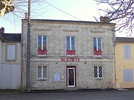
Villandraut facts for kids
Quick facts for kids
Villandraut
|
||
|---|---|---|
 |
||
|
||
| Country | France | |
| Region | Nouvelle-Aquitaine | |
| Department | Gironde | |
| Arrondissement | Langon | |
| Canton | Le Sud-Gironde | |
| Intercommunality | Canton de Villandraut | |
| Area
1
|
12.58 km2 (4.86 sq mi) | |
| Population
(Jan. 2019)
|
1,120 | |
| • Density | 89.0/km2 (230.6/sq mi) | |
| Time zone | UTC+01:00 (CET) | |
| • Summer (DST) | UTC+02:00 (CEST) | |
| INSEE/Postal code |
33547 /33730
|
|
| Elevation | 20–54 m (66–177 ft) (avg. 31 m or 102 ft) |
|
| 1 French Land Register data, which excludes lakes, ponds, glaciers > 1 km2 (0.386 sq mi or 247 acres) and river estuaries. | ||
Villandraut is a small town, also known as a commune, located in the southwest of France. It is part of the Aquitaine region and can be found in the Gironde department.
Contents
Discover Villandraut
Villandraut is a charming commune in France. A commune is like a local government area, similar to a town or a small city. It has its own mayor and local council who help run things for the people living there.
Where is Villandraut?
Villandraut is located in the Gironde department. A department is a bit like a county or a state in other countries. The Gironde department is part of the larger Aquitaine region, which is known for its beautiful landscapes and history. Villandraut is specifically in the Langon arrondissement and the Le Sud-Gironde canton. These are smaller administrative areas that help organize the region.
How Many People Live There?
As of January 2019, about 1,120 people lived in Villandraut. This makes it a small but lively community. The number of people living in a place is called its population.
Who Leads Villandraut?
The leader of Villandraut is called the mayor. From 2008 to 2014, the mayor was Dominique Payrois. The mayor is in charge of making decisions for the commune and helping its residents.
What is the Size of Villandraut?
Villandraut covers an area of about 12.58 square kilometers. To give you an idea, that's roughly the size of 1,258 football fields! The town sits at an elevation of about 31 meters above sea level, with its lowest point at 20 meters and its highest at 54 meters.
See also
 In Spanish: Villandraut para niños
 | Leon Lynch |
 | Milton P. Webster |
 | Ferdinand Smith |


