Virgilina, Virginia facts for kids
Quick facts for kids
Virgilina, Virginia
|
|
|---|---|

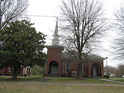
Union Christian Church
|
|

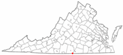
Location of Virgilina, Virginia
|
|
| Country | United States |
| State | Virginia |
| County | Halifax |
| Area | |
| • Total | 0.62 sq mi (1.60 km2) |
| • Land | 0.61 sq mi (1.59 km2) |
| • Water | 0.00 sq mi (0.01 km2) |
| Elevation | 551 ft (168 m) |
| Population
(2010)
|
|
| • Total | 275 |
| • Estimate
(2019)
|
252 |
| • Density | 223.13/sq mi (86.15/km2) |
| Time zone | UTC−5 (Eastern (EST)) |
| • Summer (DST) | UTC−4 (EDT) |
| ZIP code |
24598
|
| Area code(s) | 434 |
| FIPS code | 51-81312 |
| GNIS feature ID | 1493858 |
Virgilina is a small town located in Halifax County, Virginia, in the United States. In 2010, about 275 people lived there. This town used to be a busy place for copper mining. It was also an important stop on the Atlantic and Danville Railway until the 1950s. The town's name, "Virgilina," comes from its special location right on the border between Virginia and North Carolina.
Contents
Where is Virgilina Located?
Virgilina is found in the southeastern part of Halifax County. Its southern edge touches the border between Virginia and North Carolina. The town is located at coordinates 36.545244 degrees North and -78.773720 degrees West.
Roads and Travel
Two main roads, Virginia State Route 96 and Virginia State Route 49, meet in the center of Virgilina. VA-96 goes west for about 7 miles (11 km) to U.S. Route 501. VA-49 heads northeast for about 14 miles (23 km) to Clarksville.
Both of these highways continue into North Carolina. NC 96 goes southeast for about 20 miles (32 km) to Oxford, North Carolina. NC 49 travels southwest for about 17 miles (27 km) to Roxboro, North Carolina.
Land and Water
According to the United States Census Bureau, Virgilina covers a total area of 0.62 square miles (1.6 square kilometers). All of this area is land. The town center is on a small hill. Water from both sides of this hill flows into streams that lead to Aarons Creek. Aarons Creek then flows into the Dan River, which is part of the larger Roanoke River system.
Virgilina's Population Over Time
| Historical population | |||
|---|---|---|---|
| Census | Pop. | %± | |
| 1900 | 200 | — | |
| 1910 | 270 | 35.0% | |
| 1920 | 350 | 29.6% | |
| 1930 | 338 | −3.4% | |
| 1940 | 358 | 5.9% | |
| 1950 | 323 | −9.8% | |
| 1960 | 286 | −11.5% | |
| 1970 | 249 | −12.9% | |
| 1980 | 212 | −14.9% | |
| 1990 | 161 | −24.1% | |
| 2000 | 159 | −1.2% | |
| 2010 | 154 | −3.1% | |
| 2020 | 124 | −19.5% | |
| U.S. Decennial Census | |||
The population of Virgilina has changed over the years. In 1900, there were 200 people. The population grew to 350 by 1920, but it has slowly decreased since then. By 2020, about 124 people lived in the town.
Who Lives in Virgilina?
Based on the 2000 census, there were 159 people living in Virgilina. These people lived in 76 households, and 43 of these were families. Most of the people living in the town were White (93.08%). A small number were African American (1.66%) or Native American (1.26%).
About 15.8% of the households had children under 18 years old. Many households (42.1%) were married couples living together. About 23.7% of households had someone living alone who was 65 years old or older. The average household had about 2 people.
Age Groups in Town
The people in Virgilina are spread across different age groups. In 2000, 18.9% of the population was under 18 years old. About 26.4% of the people were 65 years old or older. The average age in the town was 46 years.
See also
 In Spanish: Virgilina (Virginia) para niños

