
Vulture Mountains facts for kids
Quick facts for kids Vulture Mountains |
|
|---|---|

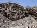
Vulture Mountain and caves in the Vulture Mine area.
|
|
| Highest point | |
| Peak | Vulture Peak (Arizona) |
| Elevation | 3,658 ft (1,115 m) |
| Dimensions | |
| Length | 29 mi (47 km) E-W |
| Geography | |

Location in Arizona
|
|
| Country | United States |
| Communities | Wickenburg, Aguila and Morristown |
| Range coordinates | 33°52′44″N 112°47′42″W / 33.87889°N 112.79500°W |
The Vulture Mountains are a dry, low-lying mountain range in Maricopa County, Arizona, United States. They stretch for about 29 miles (47 km) and are located at the northern edge of the Sonoran Desert. North and northeast of the Vulture Mountains are other mountain ranges. These areas are part of Arizona's "transition zone," where the desert meets higher lands.
Near Wickenburg, Arizona, about 14 miles (23 km) north, is Yarnell Hill. This hill leads up to the Weaver Mountains and the town of Yarnell. It marks a big change in how high the land is, from the desert to the mountains. From Yarnell Hill, you can see great views of the desert areas, including the Vulture Mountains.
Contents
What Are the Vulture Mountains Like?
The Vulture Mountains are about 29 miles (47 km) long. Near their center, they are about 13 miles (21 km) wide. The range has a curved shape, like a crescent moon. It mostly runs from east to west, getting narrower as it goes west.
Where Are the Vulture Mountains Located?
The Hassayampa River flows along the northeast side of the Vulture Mountains. This river turns south near Morristown, which is on US 60. This makes the eastern end of the mountains about 7 mi wide, right where the river's flat area is. The Hassayampa River flows into the northern part of the Hassayampa Plain. Because of this, there's a small river canyon in the northeast of the Vulture Mountains. The Wickenburg Mountains are to the northeast, and the Hieroglyphic Mountains are to the east.
What Are the Highest Points?
The highest point in the Vulture Mountains is called Vulture Peak. It stands at 3,658 feet (1,115 m) tall. You can find it in the central-eastern part of the mountain range. Another important peak is Black Butte, located in the western part of the range. Black Butte is 3,612 feet (1,101 m) high.
How to Visit the Vulture Mountains
You can reach the northern and eastern parts of the Vulture Mountains by using U.S. Route 60. This road goes through Aguila in the northwest and Wickenburg in the northeast. A part of the route also runs parallel to the Hassayampa River on the northeast side of the mountains.
Roads and Trails
A paved road cuts through the mountains from Wickenburg, heading southwest. Wickenburg is right at the base of the mountains. Many unpaved roads branch off this main road. These smaller roads lead into the mountain areas or to the southern side of the range, which is the northern part of the Hassayampa Plain.
Some unpaved roads on the eastern side of the mountains are restricted. This area is a floodplain and watershed for the Hassayampa River. The riverbed here can be as wide as 1.5 mi in some places. One important unpaved road crosses the Hassayampa River west of Morristown.
History of the Vulture Mine and Vulture City
In 1863, a man named Henry Wickenburg found the Vulture Mine. After this discovery, a small mining town called Vulture City grew up in the area. At one point, about 5,000 people lived there. However, after the mine closed, the town became empty and turned into a ghost town.
Some of the old buildings from Vulture City are still standing in the Vulture Mountains today. These structures offer a glimpse into what life was like during the mining boom.
Images for kids
-
Vulture Mountain and caves in the Vulture Mine area.
