
Wängi facts for kids
Quick facts for kids
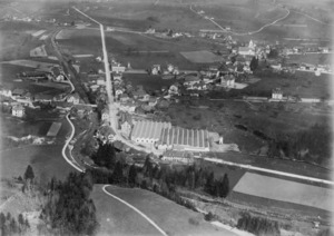
Wängi
|
||
|---|---|---|
 |
||
|
||

Wängi
Location in Switzerland

Wängi
Location in Canton of Thurgau
|
||
| Country | Switzerland | |
| Canton | Thurgau | |
| District | Münchwilen | |
| Area | ||
| • Total | 16.43 km2 (6.34 sq mi) | |
| Elevation | 470 m (1,540 ft) | |
| Population
(Dec 2020 )
|
||
| • Total | 4,766 | |
| • Density | 290.08/km2 (751.30/sq mi) | |
| Postal code |
9545
|
|
| Surrounded by | Aadorf, Bettwiesen, Bichelsee-Balterswil, Eschlikon, Lommis, Matzingen, Münchwilen, Stettfurt | |

Wängi is a town, also known as a municipality, located in the Thurgau region of Switzerland. It is part of the Münchwilen district.

Contents
Exploring Wängi's Geography
Wängi covers an area of about 16.43 square kilometers (about 6.3 square miles). A large part of this land, about 71%, is used for farming. Forests cover about 16% of the area. The rest of the land, about 12%, has buildings and roads. A very small part is rivers or lakes.
In 1969, two smaller areas called Krillberg and Tuttwil joined with Wängi. This made the municipality bigger.
Wängi's Population and People
Wängi has a population of about 4,781 people (as of 2022). Over the past ten years, the number of people living here has grown a little. Most people in Wängi speak German, which is about 90% of the population. Other languages spoken include Albanian and Italian.
In 2008, there were slightly more men than women living in Wängi. About 12.7% of the people living in Wängi are from other countries.
Historical Population Growth
The number of people living in Wängi has changed over the years. Here is a quick look at how the population has grown:
| year | population |
|---|---|
| 1950 | 2,381 |
| 1960 | 2,588 |
| 1980 | 2,909 |
| 1990 | 3,387 |
| 2000 | 3,969 |
Political Choices in Wängi
In the 2007 national election, the most popular political party in Wängi was the SVP. They received almost half of all the votes. Other popular parties included the CVP and the Green Party.
Wängi's Economy and Jobs
Wängi has a low unemployment rate, meaning most people who want to work can find jobs. In 2005, many people worked in different types of jobs:
- Primary sector: About 197 people worked in farming and related businesses.
- Secondary sector: About 689 people worked in manufacturing and industry.
- Tertiary sector: About 597 people worked in services, like shops, offices, and healthcare.
Many people who live in Wängi travel to other towns for work. However, many people also come into Wängi to work. Most people use private cars to get to their jobs, while some use public transportation.
Religion in Wängi
According to a census in 2000, the two largest religious groups in Wängi were Roman Catholics and members of the Swiss Reformed Church. Each group made up about 40% of the population. A smaller number of people belonged to other Christian churches or were Islamic. Some people did not belong to any church.
Learning and Education in Wängi
Many adults in Wängi have completed higher education, like university or special colleges. This shows that education is important in the area.
Wängi has its own school district for primary and secondary education. In the 2008-2009 school year, there were 426 students in total.
- There were 99 children in kindergarten.
- There were 149 children in lower primary school.
- There were 178 children in upper primary school.
Students usually start primary school around age 5 or 6 and continue for six years. Secondary school begins around age 12 and typically lasts for three years.
Getting Around Wängi: Transportation
Wängi is well-connected by train. The municipality has four train stations: Wängi, Jakobstal, Rosental, and Wiesengrund. All these stations are on the Frauenfeld–Wil line. This line is part of the S15 service of the St. Gallen S-Bahn, making it easy for people to travel to nearby towns.
See also
 In Spanish: Wängi para niños
