
Thurgau facts for kids
Quick facts for kids
Thurgau
|
||
|---|---|---|
|
||
 |
||
| Capital | Frauenfeld | |
| Subdivisions | 80 municipalities, 8 districts | |
| Area | ||
| • Total | 991 km2 (383 sq mi) | |
| Area rank | 12th | |
| Population
(2003)
|
||
| • Total | 228,200 | |
| • Density | 230.27/km2 (596.4/sq mi) | |
| Highest point | 991 m (3,251 ft) - Hohgrat | |
| Joined | 1803 | |
| Abbreviation | TG | |
| Languages | German | |
| Website | TG.ch | |
|
Map of Thurgau
|
||


Thurgau is a canton in the northeast part of Switzerland. It's like a state or a region within the country. About 228,200 people lived here in 2003. The main city and capital of Thurgau is Frauenfeld.
Contents
Exploring Thurgau's Geography
Thurgau has interesting borders. To the north, it touches Lake Constance. Across the lake, you can find Germany and Austria. The Rhine river forms the border in the northwest. To the south, Thurgau is next to the Canton of St. Gallen. To the west, it shares borders with the cantons of Zürich and Schaffhausen.
The canton covers an area of 991 square kilometers. It's mostly made up of three hilly areas. One area runs along Lake Constance in the north. Another is further inland, between the Thur and Murg rivers. The third hilly area forms the southern border of the canton. It connects with the Hörnli mountain, which is part of the pre-Alps.
A Look at Thurgau's History
Thurgau has a long history! Long, long ago, in prehistoric times, people from the Pfyn culture lived near the lake. Later, during the time of the Romans, this area was part of a Roman province called Raetia. Around the year 450, a group of people called the Alamanni settled here.
Thurgau as a Political Area
It wasn't until the 8th century that Thurgau started to look like a political area, similar to what we know today. It was a "Gau" (a type of region) within the Frankish Empire. Back then, its exact borders changed often. Thurgau used to be much larger. But during the Middle Ages, it became smaller. Powerful families like the dukes of Zähringen and the counts of Kyburg took over a lot of the land.
The city of Zürich was once part of Thurgau. But in 1218, Zürich became independent. When the Kyburg family ended in 1264, the Habsburgs took control of their lands.
Becoming Part of Switzerland
In 1460, the Swiss confederation teamed up with ten free areas. They took the lands of Thurgau from the Habsburgs. After this, Thurgau became a territory controlled by Zürich.
In 1798, Thurgau became a canton for the first time. This happened when it was part of the Helvetic Republic. Then, in 1803, the canton of Thurgau officially joined the Swiss confederation. The rules for how the canton is run today, called its constitution, were last updated in 1987.
Thurgau's Economy and What It Produces
The canton of Thurgau is well-known for its farms. They grow lots of apples, pears, and other fruits and vegetables. Many orchards in the canton are used to make cider, a popular drink. Wine is also produced in the Thur valley.
Besides farming, Thurgau also has industries. The main types of businesses include printing, clothing, and arts and crafts. Small and medium-sized businesses are very important for the canton's economy. Many of these companies are located near the capital city, Frauenfeld.
People and Languages in Thurgau
Most people in Thurgau speak German. When it comes to religion, most of the population are Protestants. The rest are Roman Catholics.
Thurgau's Districts
The Canton of Thurgau is divided into eight main areas called districts. Each district is named after its main town or capital.
- Steckborn with its capital Steckborn
- Frauenfeld with its capital Frauenfeld
- Kreuzlingen with its capital Kreuzlingen
- Weinfelden with its capital Weinfelden
- Bischofszell with its capital Bischofszell
- Diessenhofen with its capital Diessenhofen
- Münchwilen with its capital Münchwilen
- Arbon with its capital Arbon
Images for kids
-
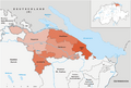
The five districts, since 2011
-
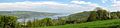
View of Untersee (Lake Constance) near Eschenz with the German shore beyond. Lake Constance and the river Rhine mark the northern border of the canton.
-
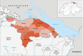
The eight former districts, prior to 2011


See also
 In Spanish: Cantón de Turgovia para niños
