
Diessenhofen facts for kids
Quick facts for kids
Diessenhofen
|
||
|---|---|---|
 |
||
|
||

Diessenhofen
Location in Switzerland

Diessenhofen
Location in Canton of Thurgau
|
||
| Country | Switzerland | |
| Canton | Thurgau | |
| District | Frauenfeld | |
| Area | ||
| • Total | 10.08 km2 (3.89 sq mi) | |
| Elevation | 398 m (1,306 ft) | |
| Population
(Dec 2020 )
|
||
| • Total | 4,085 | |
| • Density | 405.26/km2 (1,049.6/sq mi) | |
| Postal code |
8253
|
|
| Localities | Willisdorf | |
| Surrounded by | Schlatt (TG), Basadingen-Schlattingen | |

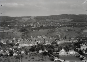
Diessenhofen is a village and a town in the Frauenfeld District of the Canton of Thurgau in Switzerland. It sits on the south bank of the High Rhine river, right across from the German town of Gailingen am Hochrhein.
Contents
History
Diessenhofen was first mentioned way back in the year 757. In 2000, the nearby village of Willisdorf became part of Diessenhofen.
Scientists have found signs of people living here since the Stone Age and Bronze Age. They found old tools and objects near the Rhine river. Coins from the Roman times (around 251–270 AD) and parts of Roman towers also show that Romans lived in this area.
In 757, a document from the Abbey of St. Gall mentioned an Alamanni village, which was likely on a hill south of the church. In 1178, Count Hartmann III of Kyburg made the village a town. He probably put a special family, called Ministerialis (knights who served a lord), in charge. By 1245, Diessenhofen was an important center with a castle. It was a small market town compared to bigger places like Schaffhausen.
Hartmann gave the town some freedom to govern itself. He used the castle and the bridge over the Rhine to protect his lands. After the Kyburg family ended and the Habsburgs took over in 1264, Diessenhofen became an important town in the region.
Over time, the citizens gained more power. By 1320, they could choose a Town Council. In the 15th century, this grew into a larger Grand Town Council.
In 1460, the Swiss Confederation took over Thurgau, including Diessenhofen. The town was under attack for ten days before it was captured. But Diessenhofen kept some special rights, like managing its own courts, customs, and taxes. It also kept control of its castle.
The church of St. Dionysius was important in Diessenhofen. In 1524, the Protestant Reformation arrived, and many people in the town became Protestant. The traditional Mass was stopped in 1529. Diessenhofen supported Zurich in a war in 1531, but the Protestants lost. After this, the Catholic cantons brought the Mass back in 1532. The church was then shared by both Protestants and Catholics until a new Catholic church was built in 1966–67.
Since the Early Middle Ages, the area around Diessenhofen was known for its farms and growing grain. People also grew grapes for wine here as early as the 9th century. For a long time, the town produced most of its own food. It also collected food from farms to send to nearby cities like Schaffhausen and Zurich.
Diessenhofen had weekly markets starting in the 12th century. By the 19th century, there were eight yearly markets! The town's businesses mostly made simple things for local needs. Diessenhofen was never a big center for international trade. However, its location on the Rhine river was good for fishing and trading salt. The town earned most of its money from bridge tolls and transit fees until these were stopped in 1848.
Geography

Diessenhofen covers an area of about 10.12 square kilometers (3.91 sq mi).
- About 41.9% of this land is used for farms.
- About 36.3% is covered by forests.
- About 16.0% has buildings or roads.
- About 5.0% is rivers or lakes.
Most of the built-up area is for industrial buildings (5.3%). Homes and other buildings make up 1.8%, and roads make up another 1.8%. Parks and sports fields cover 5.8% of the land.
The municipality shares borders with Germany and the canton of Schaffhausen to the north. To the east is the Steckborn District. To the west is the town of Schlatt, and to the south is Basadingen-Schlattingen.
| Germany | Canton of Schaffhausen | Germany |
| Schlatt TG |  |
Steckborn District |
| Schlatt | Basadingen-Schlattingen | Basadingen-Schlattingen |
Demographics

Diessenhofen has a population of about 3,300 people (as of 2008). Around 30% of the people living here are from other countries.
Most people in Diessenhofen speak German (about 81.8%). The next most common languages are Italian (5.2%) and Albanian (3.9%).
In 2008, the population was almost evenly split between males (50.7%) and females (49.3%).
The population is growing. In 2008, more babies were born than people died. Also, more people moved into Diessenhofen than moved out.
Here's a look at the age groups in 2009:
- Children (0-9 years old): 9.0%
- Teenagers (10-19 years old): 11.6%
- Young adults (20-29 years old): 13.0%
- Adults (30-59 years old): 43.7%
- Seniors (60 years and older): 22.8%
In 2000, there were about 1,325 homes in Diessenhofen, with an average of 2.4 people living in each. Most homes were single-family houses (67.1%).
The average rent for an apartment in Diessenhofen in 2000 was about 900 Swiss francs per month.
In the 2007 federal election, the most popular political party was the SVP, which got about 44% of the votes.
Here's how the population of Diessenhofen has changed over time:
| year | population |
|---|---|
| 1527 | ca 1,000 |
| 1850 | 1,616 |
| 1900 | 1,876 |
| 1950 | 2,608 |
| 1990 | 3,292 |
| 2000 | 3,227 |
Heritage sites of national significance
Several places in Diessenhofen are very important and are listed as heritage sites of national significance. These include:
- Unterhof Castle
- The City Archives in the Rathaus (Town Hall)
- The former Dominican Monastery of St. Katharinental and its granary
- The zum Goldenen Löwen House and the Goldener Leuen Collection
- The Rheinbrücke (Rhine Bridge)
- The city walls with Siegelturm (Seal's Tower)
Both the town of Diessenhofen and St. Katharinental Monastery are also part of the Inventory of Swiss Heritage Sites.
-
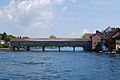
Rhine Bridge
-
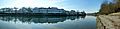
St. Katharinental Monastery
-
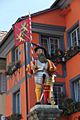
The colorful fountain's statue
-
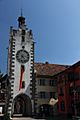
Seal's Tower (Siegelturm)


Architecture
The old part of Diessenhofen, called the Altstadt, is centered around the Siegelturm. This tower was used to keep important seals and official documents safe. The old covered bridge over the Rhine was rebuilt in 1814. It connects Diessenhofen to Gailingen am Hochrhein in Germany.

Economy
One of the three main data centers for SWIFT is located in Diessenhofen. SWIFT is a global network that banks use to send messages to each other. It's like a secure email system for banks!
In 2007, Diessenhofen had a low unemployment rate of 1.59%.
The town's economy is divided into three main parts:
- Primary sector: This includes farming and other activities that get raw materials from nature. About 74 people work in this sector.
- Secondary sector: This involves manufacturing and making things. About 668 people work in this sector.
- Tertiary sector: This is the service sector, like shops, offices, and tourism. About 901 people work in this sector.
Many people who live in Diessenhofen work outside the town (about 43.4%). But also, many people come into Diessenhofen to work. About 12.7% of workers use public transportation, and 44.7% use a private car to get to work.
Religion
Based on the 2000 census:
- About 29.6% of people were Roman Catholic.
- About 41.4% belonged to the Swiss Reformed Church (Protestant).
- Smaller numbers of people belonged to other Christian churches, the Orthodox Church, or were Islamic.
- About 8.34% of the population said they didn't belong to any church or were agnostic or atheist.
Transport
Diessenhofen is on the Lake Line railway, which connects Schaffhausen and Rorschach. The town has two train stations: Diessenhofen (near the town center) and St. Katharinental (near the old monastery).
Education
Most adults in Switzerland are well educated. In Diessenhofen, about 66.5% of people aged 25 to 64 have completed higher education, like university or a special college.
Diessenhofen has its own school district for primary and secondary schools. In the 2008/2009 school year, there were 691 students.
- Kindergarten: There were 131 children.
- Primary school: This level lasts for 6 years. There were 200 children in the lower primary and 236 in the upper primary.
- Secondary school: This level usually lasts 3 years. Students are grouped based on how well they do in school.
Notable people

Here are some famous people who were born in Diessenhofen or lived there:
- Gabriel Bucelin (1599–1681): A very smart Benedictine monk, writer, and mapmaker.
- Johann Conrad Brunner (1653–1727): A Swiss doctor known for his work on the pancreas.
- Johann Georg Rauch (1789–1851): A Swiss businessman and politician.
- Georg Fein (1803–1869): A German journalist and politician who lived in Diessenhofen.
- Conrad Brunner (1859–1927): A Swiss doctor and surgeon who studied how to clean and heal wounds.
- Richard Dobson (1942–2017): An American singer-songwriter and author who moved to Diessenhofen.
See also
 In Spanish: Diessenhofen para niños
