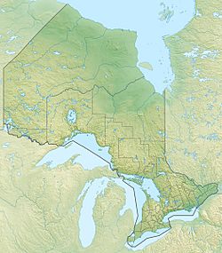
Wabatongushi Lake facts for kids
Quick facts for kids Wabatongushi Lake |
|
|---|---|
| Location | Ontario |
| Coordinates | 48°26′30″N 84°12′30″W / 48.44167°N 84.20833°W |
| Primary outflows | Lochalsh River |
| Basin countries | Canada |
| Max. length | 35 km (22 mi) |
| Max. depth | 175 ft (53 m) |
Wabatongushi Lake is a beautiful lake located in Northern Ontario, Canada. It is completely inside the Chapleau Crown Game Preserve, which is a protected area for wildlife. The lake has a very interesting shape and different types of land around it.
The northern part of Wabatongushi Lake is quite shallow and has many swampy areas. This makes it a perfect home for fish like northern pike and large animals such as moose. In contrast, the southern part of the lake is much deeper. It reaches a maximum depth of 175 feet (about 53 meters) near Loch Island Lodge. This deeper area is ideal for big game fish like walleye and northern pike. The shoreline in the south is also much higher, with ancient rocks called Pre-Cambrian shield dropping straight into the lake's tea-colored water. Many small bait fish gather near these shorelines, which then attract the larger game fish. Wabatongushi Lake is the first in a long chain of lakes that stretches almost 100 miles (160 km) and eventually flows into Lake Superior. It sits at the top of the northern watershed, meaning water flows away from it in different directions. For a long time, Wabatongushi Lake was an important travel route for both First Nations people and Voyageurs (French-Canadian fur traders) traveling between Hudson Bay and Lake Superior. In the Ojibwa language, "Wabatongushi" roughly means "White Sand Lake."
Contents
Discover Wabatongushi Lake: A Northern Ontario Gem
Wabatongushi Lake is a special place known for its natural beauty and history. It offers a unique experience for those who visit, from its diverse waters to its past as a vital transportation route.
Exploring Wabatongushi Lake's Unique Waters
The lake's different depths create homes for various animals.
- Shallow North: The northern end of the lake is shallow and marshy. This environment is perfect for northern pike, which like to hide in the weeds. It's also a great spot for moose to find food and water.
- Deep South: The southern part of the lake is much deeper. This area is excellent for catching walleye and larger northern pike. The shores here are rocky, with ancient Pre-Cambrian shield formations. These rocks drop sharply into the water, creating good spots for fish to gather.
Travel and History: Reaching Wabatongushi Lake
For many years, trains were a key way to reach Wabatongushi Lake and its wilderness.
The Algoma Central Railway's Past Role
The Algoma Central Railway (ACR) used to have a stop at the northwest end of Wabatongushi Lake. Before 2015, when passenger service stopped, the ACR train was a popular way for people to visit the lake. It brought visitors for fishing, wildlife viewing, and other outdoor activities like canoeing and kayaking. The ACR passenger train once ran from Sault Ste. Marie, with a stop at Hawk Junction, and went all the way north to Hearst. Today, this line is only used for freight trains. Wabatongushi Lake is about two-thirds of the way north on this route, at milepost 206 from Sault Ste. Marie. It is about 42 miles (68 km) north of Hawk Junction and 90 miles (145 km) south of Hearst. A lodge called Errington's Wilderness Island, which has been open since the mid-1950s, is located on an island about 1.5 miles (2.4 km) from where the ACR train used to stop.
Current Passenger Train Service
Today, the only passenger train service to Wabatongushi Lake is provided by VIA Rail. The Canadian Pacific rail siding of Lochalsh is located at the south end of the lake. From here, you can take the VIA Rail Sudbury to White River train, which is often called the "Budd Car" by local people. This train allows visitors to still access this beautiful and remote lake.
 | Selma Burke |
 | Pauline Powell Burns |
 | Frederick J. Brown |
 | Robert Blackburn |


