Waconichi River facts for kids
Quick facts for kids Waconichi |
|
|---|---|

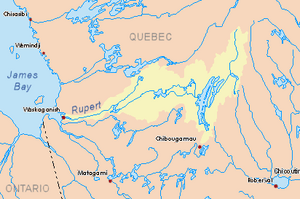
Watershed of Rupert River
|
|
| Country | Canada |
| Province | Quebec |
| Region | Nord-du-Québec |
| Physical characteristics | |
| Main source | Waconichi Lake Eeyou Istchee Baie-James, Nord-du-Québec, Quebec 386 m (1,266 ft) 50°03′17″N 74°13′53″W / 50.05472°N 74.23139°W |
| River mouth | Mistassini Lake Eeyou Istchee Baie-James, Nord-du-Québec, Quebec 375 m (1,230 ft) 50°14′44″N 73°48′57″W / 50.24556°N 73.81583°W |
| Length | 6.2 km (3.9 mi) |
The Waconichi River is a small river in Quebec, Canada. It flows into Lake Mistassini, which is a very large lake. The river is located in the Nord-du-Québec region, specifically in the area known as Eeyou Istchee Baie-James.
The entire river flows through O'Sullivan Township and the Albanel, Mistassini and Waconichi Lakes Wildlife Sanctuary. This means it's in a protected natural area. A road called Route 167 runs along the right side of Waconichi Lake and the river.
The Waconichi River usually freezes over from early November until mid-May. However, it's generally safe to travel on the ice from mid-November to mid-April.
Where is the Waconichi River?
The Waconichi River is part of a bigger water system. It's surrounded by several important lakes and rivers. To the north, you'll find Lake Mistassini and the Rupert River. To the east are File Ax Lake, Chief's River, and Ouasiemsca River. South of the Waconichi River are Waconichi Lake, Chibougamau River, and Chibougamau Lake. To the west, you'll again find Lake Mistassini and parts of the Chibougamau River.
River's Beginning and End
The Waconichi River starts at the end of Waconichi Lake. This lake is about 32.9 kilometers (20.4 miles) long and sits at an elevation of 386 meters (1,266 feet) above sea level. The river's starting point is about 5.3 kilometers (3.3 miles) southeast of where it flows into Lake Mistassini.
The river flows north for about 6.2 kilometers (3.9 miles). Along its path, it widens in three places, forming small lakes.
The Waconichi River eventually flows into a part of Lake Mistassini called Poste Bay. From there, the water continues through Lake Mistassini, heading north and then west. It passes by the village of Mistissini (Cree village municipality). The water then travels through a narrow section to reach Abatagouche Bay. After going around a long piece of land called the Abagouche Peninsula, the current crosses the rest of Lake Mistassini to its western side. Finally, it goes through a group of islands before reaching the end of the lake.
From the end of Lake Mistassini, the water flows generally west through the Rupert River all the way to James Bay.
The mouth, or end, of the Waconichi River is located about:
- 36 kilometers (22 miles) north of a bay in Chibougamau Lake.
- 94.5 kilometers (58.7 miles) south of the end of Lake Mistassini.
- 89.4 kilometers (55.6 miles) northeast of the town of Chapais, Quebec.
- 53.9 kilometers (33.5 miles) north of the city of Chibougamau.
What Does "Waconichi" Mean?
The name "Waconichi River" comes from the Cree language, which is spoken by the Indigenous people of this region. In Cree, the name means "the river of the mountain of the tripe of rock." This refers to a type of fern called "polypode of Virginia" that grows on rocks.
The name "Waconichi River" was officially recognized on July 10, 1969, by the Commission de toponymie du Québec, which is the organization in Quebec responsible for naming places.
 | William L. Dawson |
 | W. E. B. Du Bois |
 | Harry Belafonte |

