Wahgoshig First Nation facts for kids
 |
|
| Total population | |
|---|---|
| 250 (c. 2009) | |
| Regions with significant populations | |
|
Apitipi Anicinapek Nation
|
|
|---|---|
| Apitipi Anicinapek Nation | |
 |
|
| Country | |
| Province | |
| District | Cochrane |
| First Nation | AAN |
| Area | |
| • Land | 78.74 km2 (30.40 sq mi) |
| Population
(2016)
|
|
| • Total | 144 |
| • Density | 1.8/km2 (5/sq mi) |
The Apitipi Anicinapek Nation, also known as Wahgoshig First Nation, is a community of the Algonquin Anicinape people. They live in northeastern Ontario, Canada, near the town of Matheson in Cochrane District. In January 2008, about 270 people were registered with the nation. Of these, 121 lived on their reserve land.
Contents
History of the Apitipi Anicinapek Nation
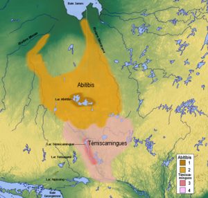
The first time these native people near Lake Abitibi were mentioned was in 1640. They were a group of nomadic hunter-gatherers. This means they moved around a lot to hunt animals and gather plants for food. Their traditional territory covered a large part of what is now northeastern Ontario and northwestern Quebec.
Their hunting and trapping lands stretched east and northeast from Long Sault to Pierre, Harris, and Montreuil Lakes in Ontario. They also went into Quebec as far east as Amos. The southernmost part of their territory was just south of Kirkland Lake in Ontario and Rouyn in Quebec. Cochrane, Ontario was roughly their western border.
Creation of the Reserve and Treaty 9
The Abitibi Indian Reserve No. 70 was created when the James Bay Treaty was signed. This happened at a Hudson's Bay Company post on Lake Abitibi in Quebec on June 7, 1906. The reserve covers about 19,239 acres, which is about 30 square miles.
However, the people who signed the treaty were only allowed to make agreements with the Anishinaabe people whose hunting grounds were in Ontario. The Abitibi people who lived in Quebec were part of the same group. They were told that a reserve for them would be discussed later. But the Quebec government delayed this process for a long time.
Sharing Resources and Name Changes
Two years after the James Bay Treaty was signed, the Canadian federal government still could not get Quebec to create a reserve for the Quebec First Nations. So, they arranged for the Quebec Abitibi people to be included under Treaty 9. This meant they would receive yearly payments and share in the money from Abitibi 70. Money from this reserve is still divided based on the number of people.
This situation has caused some economic challenges for the Wahgoshig First Nation today. Because of how the money is shared, the Wahgoshig people receive only a small part of any income from natural resources on their own reserve. This has made it less appealing to develop these resources.
Until 1972, the Department of Indian Affairs in Quebec managed the affairs of both the Abitibi-Dominion Band (in Quebec) and the Abitibi-Ontario Band. From 1972 onwards, the Indian Affairs office in Sudbury, Ontario, took over the affairs of the Abitibi-Ontario band. In 1979, the Abitibi-Dominion Band changed its name to Abitibiwinni First Nation. The Abitibi-Ontario Band became the Wahgoshig First Nation. Later, it was renamed Apitipi Anicinapek Nation.
How the Nation is Governed
The Apitipi Anicinapek Nation uses a special system called a Custom Electoral system to choose its leaders. The elected officials serve for four years. The current Chief is Joel "Bear" Babin. There are also six Councillors: Dave Morris, Chris Sackaney, Dannah Ellison, Shawna Malette, Joseph Matthews, and Paul McKenzie. The Chief started his term in April 2016, and the council began in June 2016.
Tribal Councils and Alliances
Because the First Nation signed Treaty 9, it is a member of the Wabun Tribal Council. This council is part of the Nishnawbe Aski Nation, which represents most First Nations in Northern Ontario. However, since November 2000, the Wahgoshig First Nation has also been a political member of the Algonquin Anishinabeg Nation Tribal Council. They joined this council because they have strong historical connections with its other member nations.
The Reserve Land and Environment
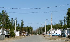
There is a village on the reserve that covers about 25 hectares (about 62 acres) of flat land. West of the village, the land becomes hilly and has many wet, swampy areas. These areas are perfect for moose. Moose, bears, grouse, and other game animals are quite common in the area.
The reserve can be reached by Highway 101. This highway connects to a 5.8 km (about 3.6 miles) long reserve road. The reserve is about 50 km (about 31 miles) east of Matheson, Ontario, and just a few miles from the western Quebec border. The northern edge of the reserve meets the south shore of Lake Abitibi, which separates the two provinces.
Community Services
The Apitipi Anicinapek Nation provides several services for the village on its reserve. These services help the community run smoothly:
- A band office, which is like the main administrative building.
- A health clinic, for medical care.
- A warehouse and fire hall, for storage and fire safety.
- A public works garage, for maintaining roads and other infrastructure.
- A community hall, for gatherings and events.
The Wahgoshig community is kept safe by the Nishnawbe-Aski Police Service. This is a police service specifically for Aboriginal communities.
 | Aaron Henry |
 | T. R. M. Howard |
 | Jesse Jackson |


